|
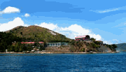
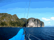
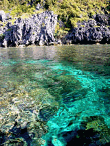
American. The town's delight included several bakeries, fresh roasted cashew nuts and a couple of Internet shops of intermediate standard. After we had our fill of town we negotiated our way through Coron harbor's serpentine channels to Coron Island, a bizarre land of stone, reef and bright lagoons. The coastline is entirely vertical. So are most of the pictures I took here! Pinnacle after pinnacle drops from a height of hundreds of feet into the sea. The indigenous Tagbanuaa people charge visitors and yachts modest sums to anchor or sightsee ashore.
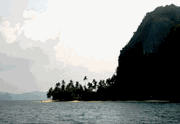
This place suited our romantic notions perfectly. Michael and I were in paradise. We took long dinghy rides along the coasts poking into every crevice, photographing and observing wild nature at its best. At one point a large lizard like creature swam past. The native people here live in only the barest of shelters on any flat bit of beach they can find. Fresh drinking water must be brought from Busuanga as the only fresh water here is inland a long way and is considered sacred, and off limits to tourists. Had we time to spare we would have like to stay much longer here, but the season advanced.
Across Coron Bay on nearby Culion is an old leper colony with high fortified walls built a long time ago to defend against Moro raids. The leper Colony dates back to 1902 when the American Administration decided to move all the stigmatized and untreated lepers in the Philippines out of their communities into this one pleasant town. Relatives came to help care for them. Their descendants have a very pleasant and interest community.
Instead of sailing well offshore in the channel we sailed inside Tambon Island. In these close quarters with scores of shallow patches and acres of oyster lines we had to take much care. Nonetheless we sailed through with our geniker flying and Harmony courageously following behind.
Dipalian Island provided us with an anchorage that night. The next morning we crossed the Linapacan Strait to Linapacan and its surrounding islands. The strong wind was mostly on the nose. Michael was thrown into temporary confusion when several islands that Michael could see did not appear on Japanese chart 757 of the area. We left both Pangaldauan and Dimanglet Islands to starboard, and then wove our way between islands and rocks awash to a cove on the NW side of Linapacan.
An explosion awakened us next morning. Men were fishing with dynamite nearby.
Today's run took us through islands so pretty they could be stand-ins for the Virgin Islands. We cut between Malubutglubut and some unnamed offshore islands trusting ourselves to navigate by the color of the water. Although of stunning beauty, the islands possessed little water shoal enough for comfortable anchorage. Depth ran around 20 fathoms. As we rounded the last bluff a panorama of uncountable islands spread away beguilingly in Taytay Bay. A month in a boat would not be enough to explore them all.
Four hundred mile long Palawan is an intriguing piece of geography. It points like a finger NE towards Mindoro and Luzon. A string of small islands on its southern tail connect it to Malaysia. Palawan has for 20,000 years made handy stops for ancient navigators moving
|
|