|
aware of its presence. Huge dirty gray cloudbanks piled up on the southern horizon, and from them, after dark, lightening flashed. We felt that we were racing north to escape its grip, but disturbed weather would envelop us in bands of vicious squalls. At the equator we had calms and popped open a bottle of champagne to celebrate.
When the wind came again it blew 15 to 20 knots out of the northeast so we tacked west. It became evident however, that we needed to continue pushing north. bypassing Tarawa to get clear of this turbulent zone. Satellite pictures from Honolulu showed thick bands of cloud being sucked up by cyclone "Zoe", even from north of the equator! All we could do was battle on.
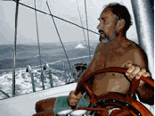
By the 11th day at sea the skies were sunny although squalls would occasionally blow through, and the strong northeast wind was strengthening. Flying fish escaping from the hungry jaws of mahi mahi skipped across the waves while porpoise frolicked under the bow. We tossed out the fishing line and hauled in bonito, yellow fin, sailfish, and mahi mahi. We ate fish for breakfast, lunch and dinner.
Christmas day passed almost without note, having no Christmas presents to exchange --- although Michael did use the day as an excuse for cutting off the beard he had encouraged since leaving New Zealand in June. We did, however, enjoy Christmas cake with our morning coffee.
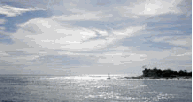
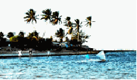
Gradually the vicious squalls abated. The northeasterly trade winds set in blowing 25 to 30 knots. It was not easy sailing but we made good speed so that by the 13th day, New Year's Eve, having sailed 1,412 miles we found ourselves at Majuro Atoll.
Majuro Atoll 31 December 2002
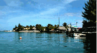
We entered through Channel Calalin, glad to watch a freighter show us the way. The pass through reef and shoals was wide and well marked. Tidal currents hardly disturbed the surface. We had barely entered the main lagoon, however, when our engine stopped. After days of pounding at sea residue in the fuel tanks had shaken loose. We continued under sail the ten miles towards the main anchorage where a group of anchored factory fishing boats with trawlers tied up beside them unloaded their catch. At 6:30 PM we rounded up through moored yachts where a launch carrying smiling Majuro men intercepted us and signaled to "Follow us".
The water off the waterfront is about 90 feet deep. A half mile away another group of yachts were anchored off a beach, but the holding, we were told there, is not wonderful. Shortly after we were secure, blue eyed Kerry arrived to tell us that tonight, New Year's Eve, local festivities would be held ashore, with barbecued foods, live bands, and dancing.
"What about customs and immigration?" we asked.
"Don't worry. They're pretty relaxed around here. The office is closed up until Thrusday. Go in then."
We took him at his word. Despite our general fatigue we jumped into the local party, soon meeting a crowd up from Kwajalein, the U.S. Military base and the largest atoll in the Pacific. It was in our plans to visit in February if we could. Later we again met Kerry who introduced us to his Australian wife Karyn, and several other locals off boats. After midnight we slumped into our dinghy to paddle home, glad after so many long days at sea to have been welcomed so warmly to Majuro.
Majuro, 1,900 miles west of Hawaii, offered a good air con
|
|