![]() The Ruins of Mexico: Virtual Tour Website
find a
site home
The Ruins of Mexico: Virtual Tour Website
find a
site home
![]()
|
|
|
Area N: Yucatán Peninsula - South
State of Campeche
By car is the only way to reach this amazingly hidden city. The sixty-kilometre road to it branches off from highway 186, linking Xpuhil and Escárcega, some one hundred and ten kilometres east of the latter town - the turning is well marked. This road is well maintained and for the first fifteen or so kilometres is straight and wide. Unfortunately, the highway then narrows, and twists and turns alarmingly through darkened forest for the remainder of the distance. The use of mosquito repellent is advisable at all times of the year. Culture: Southwest Maya
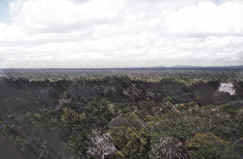
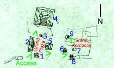
Calakmul was discovered quite late in the day in Mexican archaeology - in 1931 - and subsequent efforts have therefore been to try to fit it into the general picture of Mayan chronology. It has now been identified as the centre of the powerful Serpent's Head Kingdom, alluded to in records found at other sites. This empire held sway during the years from 250 to 500AD and there were conflicts with the other major Classic sites of the time. A final, failed attack on Tikal, the biggest empire of them all, led to the decline of Calakmul as a super-state, but the successive rulers re-aligned their ties to the Río Bec region that brought about a brief renaissance and had a big influence on architectural styles. For more about other Rio Bec Maya cities, see Cultural History. Tour (Scroll down to follow complete tour, or click on feature below and use your BACK key to return to the map) From the car park, there is a long, sweaty walk of half an hour to get to the actual ruins, so take plenty of water. The open areas themselves are shrouded by the thick forest canopy and one of the problems here is to get an overall sense of the city's proportions.
We see some quite ruined structures to our left before the path finally opens out into the Grand Plaza which is so filled with trees that the buildings that frame it are shadowy shapes through the branches. To our right we see Structure VII, one of the tallest edifices on view here. It is a bulky pyramid of the massive, imposing scale characteristic of buildings at Calakmul. It is, however, different from the others in that it once had stairways on all four sides. This, and its orientation, has led some to conclude that it was conceived as an observatory.
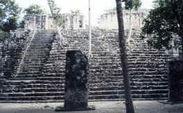
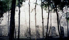
To our left, where we came into the plaza, we see Structure IV, a more complex affair. It consists of a long platform with wide steps leading up to a temple area and with two pyramidal parts at each end and one in the centre. Apparently, this building was the result of successive additions; originally it was one of the oldest constructions here. There are several stelae erected in front of it. Structure IV The Grand Plaza is bordered on the north side by Structure V, a more modestly sized platform with wide steps and surmounted by stelae that has been thought to contain Río Bec influences.
We will leave the Grand Plaza for the moment to examine the largest and most impressive building at Calakmul. It stands to the north of the plaza and has been labelled Structure II. It is a monumental, pyramidal building of several tiers with a long, sloping stairway leading up to a crowning temple, which was a later addition and has been marked Structure I. From the top, a grand view of the miles of untouched jungle can be afforded. The colosal scale of this building can only be marvelled at and we can imagine that it probably formed the heart of important ritual ceremonies.
If we return to the Grand Plaza and cross over to its western side, we encounter Structure VI. This is a simple pyramidal platform with the typical wide stairs leading to a former temple on top, thought by some to have had some astronomical alignment along with Structure VIII.
We now follow a trail that leads around the right limb of Structure VI and heads towards the Grand Acropolis, an open area (now also obscured by trees) with buildings that is actually larger than the Grand Plaza just visited. We pass the back of one temple named Structure XIV, noted for the fact that it has steps on both sides. Structure IV In front of us we see Calakmul's Ball Court, or Structure XI. It is averagely sized in terms of such features and from a nearby stela, it has been determined that this was built in 751, on the accession to power of one Bolon Kawil.
Structure XIII, to our right, is interesting because it is the only surviving building at this site with a vaulted roof. This temple has one door way and lies atop a wide, stepped platform.
The other well-restored building in the Grand Acropolis is Structure XV, on the other side of a mound separating it from Structure XIV. This was built in 672 as a funeral monument for a leader known as Jaguar's Paw and the later Río Bec influence is apparent here with its similarity to buildings at Becán, for instance. Structure XV As can be seen, there are several other constructions and mounds that line the area in lesser states of preservation. Apparently, the total area has been mapped completely, and so we only await further restoration work to make these ruins even more fascinating to visit. Home Find Another Site Back to Yucatán Peninsula - South Area Map |
 Structure VIII
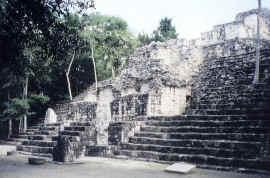
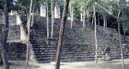 Structure V
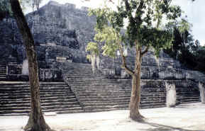 Structure II
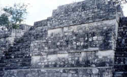
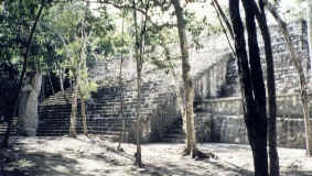 Structure VI
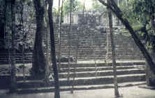
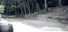 Ball Court
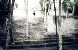 Structure XIII