![]() The Ruins of Mexico: Virtual Tour Website
find a
site home
The Ruins of Mexico: Virtual Tour Website
find a
site home
![]()
|
|
|
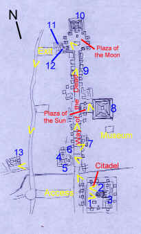
Area F: State of Mexico - East
Avoid the expensive tours that are sold in the centre of Mexico City (the guides charge a lot and rely on vivid but mostly hypothetical accounts of life in the ancient city). Go to the Terminal Norte de Autobuses (yellow metro line) and from there, frequent and inexpensive buses leave to the zone. The journey takes less than an hour. There are a multitude of services available including on-site museum and shops, but everything is over-priced, as expected, so buy your supplies before arriving. The ornament vendors inside the site can be tiresome. Take precautions against the sun at all costs; there is not a scrap of shade. A lot has been written about the ruins of Teotihuacan, and the purpose of this section is, as with the other sites mentioned, to give a description of most of the features worth visiting with images of each one. More detailed histories can be found from other worthier sources. Culture: Classic, Central Mexico
Always the focus of intense speculation, the amazing fact about the builders of the most impressive display of civil planning, design, and construction in pre-Columbian America, is that they have remained largely unknown. When the Spanish arrived, the occupants of the city were long forgotten, and even the Aztecs had also found it overgrown and abandoned and went on to believe that it had been built by a race of giants. It is only through the laborious process of archaeology that any knowledge at all about this extraordinary civilisation has slowly risen to the surface. Up to 200BC, there was moderate population of the Teotihuacan area, but this was followed by a veritable explosion in a hundred years in which one of the biggest cities of the world at that time was created. What caused this change? Some archaeologists point to a cave shaft located beneath the Pyramid of the Sun. The cave has been thought to have been considered as the point of origin of the sun, stars and people and therefore its discovery may have given birth to a cult that became the most powerful religious and political force in pre-Hispanic Mexico. In the next few centuries, Teotihuacan established a stronghold on the whole of Central Mexico and had important influences on the whole country, extending as far as modern Guatemala. From 450 to 650AD, there was an extraordinary era of political stability and relative peace, but as evidence is now beginning to bear witness to, the Teotihuacanos were no strangers to human sacrifice and probably saw more than one despotic ruler exercise power over the empire. Inevitably there was a slowing down of the city's expansion, and around 650 the decline of Teotihuacan began. No one is quite sure as to the cause of this, but there may have been many factors, such as political rivalry, bad planning, social breakdown, poor agricultural management, pressure from other rival groups; but one thing is certain and that is that in 725, the city was razed and burned. Again, it is not clear whether this was the result of a fatal civil conflict or invasion from barbarians, but this event effectively ended Teotihuacan's position as an empire, although a skeleton population lived on in the ruined city for centuries to come. Now the power base of Central Mexico would shift, in time, to Tula and the rise of the Toltecs. For more about other Classic Cities of Central Mexico, see Cultural History. Tour (Scroll down to follow complete tour, or click on feature below and use your BACK key to return to the map) -this page is awaiting further development The archaeological zone of Teotihuacan is vast, and unless you arrive very early or have a lot of stamina, the features listed in this tour will probably not be able to be seen in one day. Prioritise, if you wish.
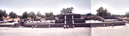
There are three official entrances on the west side of the ruins, but we will start our tour at the southwesterly one, the largest and the first that we come to. After passing through the entrance compound, we find ourselves at the south end of Teotihuacán. Before us stands a stepped platform. This gives access to the Citadel, the largest enclosed space in the city. The raised platform forms a square around the arena with stairways and stepped temple constructions at intervals. The flat plaza is huge - measuring 390 metres on each side - and capable of holding thousands of people. It is thought to have been used for ceremonies and the perimeter platform was to stop ordinary citizens from seeing inside.
In the centre we find a stepped altar and near to it a low, covered structure called the Superimposed Shrine. On its sides, we see coloured murals and designs. Superimposed Shrine At the far end of the Citadel is its main attraction, the Temple of the Feathered Serpent. This actually consists of two structures, the one in front being newer and superimposed on the older building.
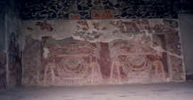
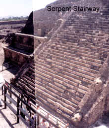
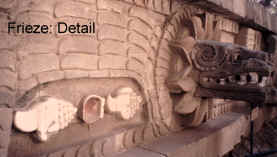
In the gap between the two buildings, we find a walkway that gives access to a viewing area constructed from one half of the newer building. Now we can see the best preserved section of the older pyramid that was erected and decorated in honour of the Feathered Serpent cult; a powerful religious movement that was spawned here, delivered to every corner of Mexico and continued, in various forms, right up to the Spanish Conquest. Numerous serpent heads protrude from the walls and repeated motifs show coloured shells and monster masks. Detailed artwork of this kind, and restored so well, is not common among ancient sites.
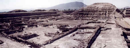
Leaving the temple, we will ascend the surrounding platform again and walk around to the temple's far (east) side, where we will encounter a vast residential complex. This consists of a multitude of rooms and patios, interconnected by access points and corridors. This is the largest example of such a complex in Mexico, and although many of the walls are ruined, we still get a very good idea of how it once looked. A number a sacrificial victims have been discovered buried in this section; it almost certainly functioned to house the elite group of the city.
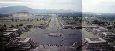
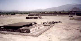
Citadel Residential Complex Retracing our steps back out of the Citadel altogether, we find that we are at the end of a wide, monumentally long ancient avenue that runs directly north towards the large structures we can tantalisingly see in the distance that include the Pyramid of the Sun and Moon. This avenue is known as the Way of the Dead; the main street of Teotihuacan that exactly dissects it and along which we will find most of the features of the rest of this tour. Its name arose from the temples lined along its sides that were thought to be funerary buildings. After crossing a stinking stream and a path that leads east to the site's museum, the Way of the Dead enters the main ceremonial area of the city and at this point proceeds in the form of five platforms or plazas, accessed by stepped platforms that cross it laterally. It is not clear whether these plazas were actually conceived of separately or part of the whole avenue.
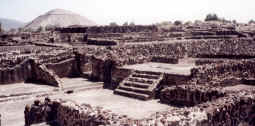
To the left (west) of the first, largest plaza with a shrine in the centre, we find an entrance to a fascinating area of rooms and patios. Being in the ceremonial heart of Teotihuacan, we can sumise that they were mostly elite residences and private ritual areas. The walkway leads first to the Complex of the Superimposed Buildings. We descend some steps into an interior characterised by stepped structures and columns arranged on top of each other, but this is of course a view of multiple additions and extensions. We see several pyramidal structures with coloured murals. Superimposed Temple Just south of this, but currently out of bounds, is the so-called North-West Group, consising of a labyrinth of interconnecting ruined rooms and patios.
To the north, we enter a zone known as the West Plaza Group. This is a similarly designed complex but is open for exploration. Of particular interest is the West plaza itself, a patio ringed by temples, one of which retains decoration and serpent head sculptures. Most structures show evidence of several stages of construction and older, half-buried buildings. West Plaza Group Returning to the Way of the Dead, we make our way to the third enclosed plaza and on the right side this time, we should see a cluster of buildings known as the Viking Group (named after an organisation that had sponsored the restoration). This is apparently a palace complex and comprises a central pyramidal building and plaza behind it, surrounded by rooms with columns that face on to the main avenue.
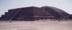
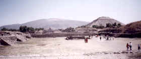
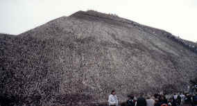
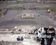
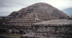
Continuing up the Way of the Dead, we will come into a open area to the left, named the Plaza of the Sun, and before us rises the enormous shape that has dominated the vista the closer we have got to it. This is the famous Pyramid of the Sun, which to the mind of this writer is the most impressive sight that Mexico has to offer in the way of archaeological features. Although actually not the largest pyramid to be found in the country, it is the most spectacular and one of the best restored.
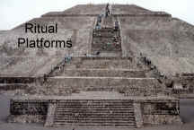
Pyramid of the Sun Numerous excavations into the Pyramid of the Sun's interior have revealed that it is completely solid, but originally built over a volcanic cave entrance that held deep religious significance to the city's founders. The entrance to this lava shaft lies at the base of the pyramid, but it is permanently gated. Also located at this west side of the pyramid are some platforms superimposed on to the pyramid's body. These were ritual buildings added at later dates in the city's history.
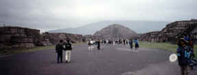
The climb up the Pyramid of the Sun's stairway is a tiring one and the narrow way can become quite packed with people. There is nothing of particular interest at the top, apart from the best view over the city, and the slightly rounded summit once supported a temple with a five-metre high statue that was destroyed by the Spanish. We can see from here the total extent of the city and also the multitude of regularly shaped humps and mounds on the fringes that show that there is still a great deal of restoration and excavation to be done here. Just to the immediate north of the pyramid is a clearly defined but ruined complex of buildings and patios (named here as the Sun Complex). We will continue walking north up the Way of the Dead which at this point becomes one wide, flat street lined on both sides with stepped pyramidal temples that have been well preserved. At the end, we spy the imposing Pyramid of the Moon.
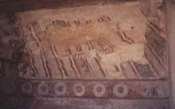
To the right, we encounter the Temple of the Jaguar Mural. The mural itself faces the avenue and is partly destroyed, although its colours and form remain.
The Way of the Dead terminates at last at the Plaza of the Moon, an impressive open space ringed by stepped pyramidal temples and by the Pyramid of the Moon itself on the north side. There are two large altar-like platforms in the centre that were used for religious ceremonies. Plaza of the Moon (looking
N) The Pyramid of the Moon stands 46 metres high and is an impressive feature in its own right, even more so if it were not for the Pyramid of the Sun; although some argue that this pyramid is more aesthetically pleasing. It can be climbed, like its larger sister, by a single stairway, although near the top, the building has not been restored very well. There is a large platform superimposed in to the front of the pyramid, again added at a date after the original construction.
The amazing level of planning and design of Teotihuacan can be appreciated from the Pyramid of the Moon's summit. The main street is like an arrow, surrounded by precisely geometrically arranged buildings.
Grand Vista: Looking S from Pyramid of the Moon
On the west side of the Plaza of the Moon is another interesting complex of buildings. A set of stairs will take you through a colunaded entrance into an enclosed patio surrounded by decorated columns and wall motifs. This is known as the Palace of the Quetzal Butterfly. A path leads around to the left of this building and down into an underground chamber centred around an elaborately decorated temple structure. Known as the Palace of the Plumed Conches, we see on it a repeated motif of green macaw-like birds and flowers. This terminates the tour of the main area of Teotihuacan. If time and energy permit (and they probably will not on the first trip here) there are some interesting apartment complexes to be seen outside the southwest section of the city. We can get there by the Plaza of the Moon main exit and walking south along the road until a dirt track can be seen branching right. A short distance down this, we see a large building to the right. This is the Palace of Tetitla; the largest of the complexes. It is a square, one-storey structure whose interior consists of a labyrinth of rooms, patios and corridors; some are highly decorated with murals and painted designs, the most superior of any yet found at Teotihuacán.
Palace of Tetitla -this page is awaiting further development |
 The Citadel
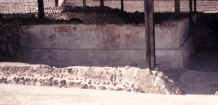
 Temple of the Feathered Serpent
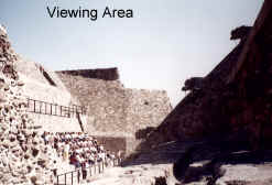
 Way of the Dead: Plaza Level
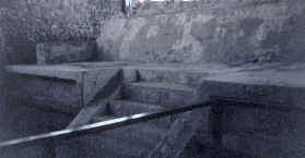
 Northwest Group
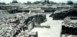
 Viking Group
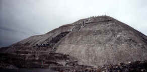
 Jaguar Mural
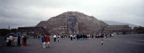
 Pyramid of the Moon