GENERAL INFORMATION
LOCATION
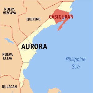
The municipality of Casiguran is located at the northern part of Aurora Province, about 121 kms, from Baler, capital town of Aurora Province. It lies between 26.01 "39" and 16.21' 53" north latitudes and between 121 52' 23" and 122 14' 14" east longitudes. It is bounded on the northern east by the municipality of Dilasag, on the southwest by Dinalungan, on the northwest by Quirino Province and southeast by the Pacific Ocean.
CLIMATE
Rainfall - high and extreme rainfall events are most likely to occur in the period from October, November and December. Wind and Tropical Cyclones.
ACCESSIBILITY
Casiguran is accessible on land by vehicles and on sea by motorized bancas. The land transportation traverses a stretch of coastal road (national road) measuring about 121 km. Long from Baler to the center of the Poblacion of Casiguran. The road is almost 90% gravel field, thus, travelers normally experienced hardship and inconveniences along the way especially during bad weather.
LAND CLASSIFICATION
Casiguran is classified into two (2) major land classifications, viz: forestland and alienable and disposable land. About 85% of the municipality's land area are classified and 15% A and D lands.
INDUSTRY AND INVESTMENT PRIORITIES
A. Consumer Durables / Giftware & Holiday Decor (GHD) / Wearable
1. Poroycraft
2. Abaca craft
3. Sabutancraft
B. Food and Food Preparations
1. Processing of Coconut (One Town One Product Industry or OTOP)
2. Processed Root crops (ube, cassava, sweet potato, gabi)
3. Processed Peanut
C. Home Furnishing
1. Furnishing part and components
D. Others
1. Industrial Tree Plantation/Community Forest Development Project
2. Tourism
3. Inland Fishery and Aquaculture
4. Public Utilities/Infrastructure (Telecom, Power Generation, Port Facilities, Internet Cafe, etc.)
5. High-Value Crops Production
6. Industrial Estate/Ecozone Development
E. Aurora Pacific Eco Zone
Modernity with a touch of green.
In a world where distance remains a constant hurdle to the realization of possibilities, man must strive to bridge the gaps of geography. In an effort to defy distance and expand the realm of possibilities that rise on the East, the nation endeavors to present its latest innovation with a touch of green, the Aurora Pacific Economic Zone. Dubbed as the "Gateway to the Pacific", the Ecozone is depicted as the country's first economic zone located in the Pacific Coast and the only transshipment port facing the East. It is a custom designed seaport and airport driven economic center which seeks to promote tourism and rake in investments in aquamarine, agro-industrial, commercial trading, banking, outsourcing and financial industries. The Ecozone, strategically situated in the Municipality of Casiguran, is expected to operate as a major transshipment hub going to the pacific region. It aims to boost social, economic and industrial developments in Aurora and nearby provinces by generating jobs for the people, improving the quality of their living conditions, advocating an eco-friendly approach to industrialization and enhancing the potential of the community in productivity.
Experience the beauty of our vibrant green community.
The Aurora Pacific Economic Zone captures the elegance of nature and incorporates it into the distinct face of a vibrant community. The zone projects the concept of development as a picturesque imagery embellished with the luscious green life amidst rich tropical sceneries, soothing waters and diverse species of flora and fauna. It advocates the practice of manufacturing structures and implementing business processes that are environmentally responsible and resource-efficient. It is the first green economic zone in the Philippines to utilize wind power and solar cells for energy and fresh water springs for potable water.
To know more, visit www.aurorapacific.com.ph
POPULATION
In the 1960, the recorded population of Casiguran was 6,900 persons. This was almost double in the 1970 censual year where the population was recorded as 12,128, an increased of about 76% or 5.8% annual average rate of population change.
Between the 1970 and 1975, there was a mark decrease in the number of population from 12,128 to 11,670. This reduction of population can be attributed to deteriorated peace and order situation in the place, which force some of the population to move out of the municipality’s jurisdiction.
The decrease in the 1975 censual population was reverse in the 1980, which increase by 19%, or annual average growth rate increasing population continues during the succeeding censual years (1980 to 1985) but declining annual average population growth rates. The decline annual growth rates during this periods is attribute to the gradual and eventual stoppage of logging operation in the area which affected those directly engage in said activity who were not original residents of the place and decided to leave.
Between the 1995 and 1999 a significant increase on annual average growth of 4.30% was experience by the municipality. With this present growth rate, the municipality of Casiguran is expected to have an additional 25% increase in its 2009 project population level.
POPULATION DENSITY
The population density of the Poblacion in 2002 was estimated at 3,566 Persons/km2. But the population density of each (8) barangays constituting the Poblacion varies from 4,930 Persons/km2 (Brgy. 03). As expected the Poblacion portion of Casiguran has the highest population density. This is attributed on its limited land area and being the center of the economic activities in the municipality where people normally concentrate.
In other barangays, outside the Poblacion, the population densities considered significantly low expect for Brgy. Bianoan which has the population density of 3,754 Persons/km2. The rate ranges from as 6 Persons/km2. (Tabas to as high as 845 Persons/km2(Lual).
AGE STRUCTURE
Young population with age range 29 years old and below accounted for 6,479 persons or 29.9% of the municipality's population, while age range 21 to 64 years old accounted for individuals 14,585 or 65.5% and remaining 4.6% were old population 65 years old and above.
In terms of population distribution by Barangay Bianoan had the biggest number of population of 3,754 or 16% of the entire population of the municipality. The lowest population was found in Barangay 03 with 260 individuals.
HOUSEHOLD NUMBER AND SIZE
Casiguran had a total household population of 4,447. It ranges from a low of 67 in Barangay 07 to a high of 691 in Barangay Bianoan. The average household size is 5.0 Barangay 03 had the least household size of 3.6 while Barangay Cozo had the largest household size of 5.7.
EDUCATION
Elementary schools in Casiguran providing the venue of academic activities in support of the educational needs of the municipality's schooling population ar138 classrooms, of which of 39 in Casiguran Central Elementary School located in Barangay 08. The DepEd employed 194 teachers serving 138 classrooms, of which 39 are in Casiguran Central Elementary School located in Barangay 08. The DepEd employed 194 teachers serving 4,007 pupils. Teachers to pupils' ratio 1:39. The aggregate area occupied by these schools is 25.56 has.
For the secondary level, three (3) public schools exist in the municipality namely: the Casiguran National High School (Brgy. Estevez) Lual public High School (Brgy. Lual) and the extension of Lual Public High School at Dibacong public High School. These schools have combined classroom of 32, teaching force of 48 teachers and total enrollees of 1,542. The teacher to student ratio is 1:35.
In addition to public elementary and high school, Casiguran has private schools both located in the Poblacion. These are the Mount Carmel High School (MCHS) and the seventh Adventist Elementary School (SDA). The MCHS has 17 classrooms, 22 teachers and 561 pupils. On the other hand, the SDA has 3 classroom, 3 teachers and 60 pupils.
HOUSE AND BUILDING
The existing housing and building of the municipality is dominated by residential houses such as single and duplex types with total number of 4,852 units. While commercial and industrial buildings each have 120 units and institutional buildings accounted for 31 units.
HEALTH AND SERVICES
Health service facilities in Casiguran include a District Hospital, a municipal Health Center and Barangay Health Station.
INDIGENOUS CULTURAL COMMUNITIES
According to the commission on indigenous Peoples (NCIP) there are at present 721 indigenous people inhabiting within the municipality of Casiguran. Of this total, 591 and are Dumagats and Igorots with household numbers of 134 and 48, respectively Barangay Calabgan and Culat are the non-Christian reservation areas for Agtas in Casiguran. The reservation areas in Calabgan and Culat cover 152.6 and 69 hectares, respectively. Relocation survey of Culat has not yet been done.
HISTORY
According to a folk legend, the name Casiguran was obtained from the word "Kasiguruhan" which simply "safety" or "assurance". Safety means defense/fortress or sanctuary for sailing ships during stormy weather. On the other hand, assurance means that if an unmarried stranger comes to place, he unavoidably falls in love with someone and eventually gets married.
Casiguran was founded the Spanish Missionaries on 13 June 1609. But prior to their arrival, the early settlers of the place were the Dumagats/Aetas followed by migrants from other places of the country. These migrants spoke different dialects such as Ilocano, Visayan, Bicolano, Pampango, Gadang, Itawes and Ibahag. Thus, a "Kasiguranin" language evolved out of these dialects.
When the Philippines become independent on 04 July 1946, Aurora was still part of Tayabas Province (now Aurora Province) and Casiguran was a lone northern town. It political jurisdiction is bounded on the north by the province of Isabela, on the west by Quirino Province, and on the south west by barangay Dinadiawan which was then the boundary between Baler and Casiguran.
In 1959 and 1966, the barrios of Dilasag and Dinalungan which were part of Casiguran and situated on its northern and southwest portions, respectively were created municipalities.
LOCATION
The municipality of Casiguran is located at the northern part of Aurora Province, about 121 kms, from Baler, capital town of Aurora Province. It lies between 26.01 "39" and 16.21' 53" north latitudes and between 121 52' 23" and 122 14' 14" east longitudes. It is bounded on the northern east by the municipality of Dilasag, on the southwest by Dinalungan, on the northwest by Quirino Province and southeast by the Pacific Ocean.
CLIMATE
Rainfall - high and extreme rainfall events are most likely to occur in the period from October, November and December. Wind and Tropical Cyclones.
ACCESSIBILITY
Casiguran is accessible on land by vehicles and on sea by motorized bancas. The land transportation traverses a stretch of coastal road (national road) measuring about 121 km. Long from Baler to the center of the Poblacion of Casiguran. The road is almost 90% gravel field, thus, travelers normally experienced hardship and inconveniences along the way especially during bad weather.
LAND CLASSIFICATION
Casiguran is classified into two (2) major land classifications, viz: forestland and alienable and disposable land. About 85% of the municipality's land area are classified and 15% A and D lands.
INDUSTRY AND INVESTMENT PRIORITIES
A. Consumer Durables / Giftware & Holiday Decor (GHD) / Wearable 1. Poroycraft
2. Abaca craft
3. Sabutancraft
B. Food and Food Preparations
1. Processing of Coconut (One Town One Product Industry or OTOP)
2. Processed Root crops (ube, cassava, sweet potato, gabi)
3. Processed Peanut
C. Home Furnishing
1. Furnishing part and components
D. Others
1. Industrial Tree Plantation/Community Forest Development Project
2. Tourism
3. Inland Fishery and Aquaculture
4. Public Utilities/Infrastructure (Telecom, Power Generation, Port Facilities, Internet Cafe, etc.)
5. High-Value Crops Production
6. Industrial Estate/Ecozone Development
E. Aurora Pacific Eco Zone
Modernity with a touch of green.
In a world where distance remains a constant hurdle to the realization of possibilities, man must strive to bridge the gaps of geography. In an effort to defy distance and expand the realm of possibilities that rise on the East, the nation endeavors to present its latest innovation with a touch of green, the Aurora Pacific Economic Zone. Dubbed as the "Gateway to the Pacific", the Ecozone is depicted as the country's first economic zone located in the Pacific Coast and the only transshipment port facing the East. It is a custom designed seaport and airport driven economic center which seeks to promote tourism and rake in investments in aquamarine, agro-industrial, commercial trading, banking, outsourcing and financial industries. The Ecozone, strategically situated in the Municipality of Casiguran, is expected to operate as a major transshipment hub going to the pacific region. It aims to boost social, economic and industrial developments in Aurora and nearby provinces by generating jobs for the people, improving the quality of their living conditions, advocating an eco-friendly approach to industrialization and enhancing the potential of the community in productivity. Experience the beauty of our vibrant green community. The Aurora Pacific Economic Zone captures the elegance of nature and incorporates it into the distinct face of a vibrant community. The zone projects the concept of development as a picturesque imagery embellished with the luscious green life amidst rich tropical sceneries, soothing waters and diverse species of flora and fauna. It advocates the practice of manufacturing structures and implementing business processes that are environmentally responsible and resource-efficient. It is the first green economic zone in the Philippines to utilize wind power and solar cells for energy and fresh water springs for potable water. To know more, visit www.aurorapacific.com.ph
POPULATION
In the 1960, the recorded population of Casiguran was 6,900 persons. This was almost double in the 1970 censual year where the population was recorded as 12,128, an increased of about 76% or 5.8% annual average rate of population change. Between the 1970 and 1975, there was a mark decrease in the number of population from 12,128 to 11,670. This reduction of population can be attributed to deteriorated peace and order situation in the place, which force some of the population to move out of the municipality’s jurisdiction. The decrease in the 1975 censual population was reverse in the 1980, which increase by 19%, or annual average growth rate increasing population continues during the succeeding censual years (1980 to 1985) but declining annual average population growth rates. The decline annual growth rates during this periods is attribute to the gradual and eventual stoppage of logging operation in the area which affected those directly engage in said activity who were not original residents of the place and decided to leave. Between the 1995 and 1999 a significant increase on annual average growth of 4.30% was experience by the municipality. With this present growth rate, the municipality of Casiguran is expected to have an additional 25% increase in its 2009 project population level.
POPULATION DENSITY
The population density of the Poblacion in 2002 was estimated at 3,566 Persons/km2. But the population density of each (8) barangays constituting the Poblacion varies from 4,930 Persons/km2 (Brgy. 03). As expected the Poblacion portion of Casiguran has the highest population density. This is attributed on its limited land area and being the center of the economic activities in the municipality where people normally concentrate. In other barangays, outside the Poblacion, the population densities considered significantly low expect for Brgy. Bianoan which has the population density of 3,754 Persons/km2. The rate ranges from as 6 Persons/km2. (Tabas to as high as 845 Persons/km2(Lual).
AGE STRUCTURE
Young population with age range 29 years old and below accounted for 6,479 persons or 29.9% of the municipality's population, while age range 21 to 64 years old accounted for individuals 14,585 or 65.5% and remaining 4.6% were old population 65 years old and above. In terms of population distribution by Barangay Bianoan had the biggest number of population of 3,754 or 16% of the entire population of the municipality. The lowest population was found in Barangay 03 with 260 individuals.
HOUSEHOLD NUMBER AND SIZE
Casiguran had a total household population of 4,447. It ranges from a low of 67 in Barangay 07 to a high of 691 in Barangay Bianoan. The average household size is 5.0 Barangay 03 had the least household size of 3.6 while Barangay Cozo had the largest household size of 5.7.
EDUCATION
Elementary schools in Casiguran providing the venue of academic activities in support of the educational needs of the municipality's schooling population ar138 classrooms, of which of 39 in Casiguran Central Elementary School located in Barangay 08. The DepEd employed 194 teachers serving 138 classrooms, of which 39 are in Casiguran Central Elementary School located in Barangay 08. The DepEd employed 194 teachers serving 4,007 pupils. Teachers to pupils' ratio 1:39. The aggregate area occupied by these schools is 25.56 has. For the secondary level, three (3) public schools exist in the municipality namely: the Casiguran National High School (Brgy. Estevez) Lual public High School (Brgy. Lual) and the extension of Lual Public High School at Dibacong public High School. These schools have combined classroom of 32, teaching force of 48 teachers and total enrollees of 1,542. The teacher to student ratio is 1:35. In addition to public elementary and high school, Casiguran has private schools both located in the Poblacion. These are the Mount Carmel High School (MCHS) and the seventh Adventist Elementary School (SDA). The MCHS has 17 classrooms, 22 teachers and 561 pupils. On the other hand, the SDA has 3 classroom, 3 teachers and 60 pupils.
HOUSE AND BUILDING
The existing housing and building of the municipality is dominated by residential houses such as single and duplex types with total number of 4,852 units. While commercial and industrial buildings each have 120 units and institutional buildings accounted for 31 units.
HEALTH AND SERVICES
Health service facilities in Casiguran include a District Hospital, a municipal Health Center and Barangay Health Station.
INDIGENOUS CULTURAL COMMUNITIES
According to the commission on indigenous Peoples (NCIP) there are at present 721 indigenous people inhabiting within the municipality of Casiguran. Of this total, 591 and are Dumagats and Igorots with household numbers of 134 and 48, respectively Barangay Calabgan and Culat are the non-Christian reservation areas for Agtas in Casiguran. The reservation areas in Calabgan and Culat cover 152.6 and 69 hectares, respectively. Relocation survey of Culat has not yet been done.
HISTORY
According to a folk legend, the name Casiguran was obtained from the word "Kasiguruhan" which simply "safety" or "assurance". Safety means defense/fortress or sanctuary for sailing ships during stormy weather. On the other hand, assurance means that if an unmarried stranger comes to place, he unavoidably falls in love with someone and eventually gets married. Casiguran was founded the Spanish Missionaries on 13 June 1609. But prior to their arrival, the early settlers of the place were the Dumagats/Aetas followed by migrants from other places of the country. These migrants spoke different dialects such as Ilocano, Visayan, Bicolano, Pampango, Gadang, Itawes and Ibahag. Thus, a "Kasiguranin" language evolved out of these dialects. When the Philippines become independent on 04 July 1946, Aurora was still part of Tayabas Province (now Aurora Province) and Casiguran was a lone northern town. It political jurisdiction is bounded on the north by the province of Isabela, on the west by Quirino Province, and on the south west by barangay Dinadiawan which was then the boundary between Baler and Casiguran. In 1959 and 1966, the barrios of Dilasag and Dinalungan which were part of Casiguran and situated on its northern and southwest portions, respectively were created municipalities.