 | ||||||
| Articles | Projects | Resume | Cartoons | Windsurfing | Paintings | Album |
Analysis of Soils at Royal Roads University
by Waterose et. al.

Section 4. Soil Classification:
4.1 Introduction:
4.2 Soil Classification:
4.3 Discussion and Conclusion:
4.1 Introduction:
The classification of soil samples is based on the taxonomic Canadian system of soil classification. The broadest level of classification is the Order which is based on the properties of the soil pedon that reflect the nature of the soil environment and the effects of the dominant soil-forming process. The next level of soil classification is the Great Group which is based on the properties of the soil that reflects the less dominant soil soil-forming process. The third level of soil classification is the Subgroup which is based on the finer differentiation between the soil horizons.4.2 Soil Classification:
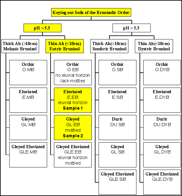
The characteristics of the soil samples are summarised in Table 8 below. The methods to key out or distinguish between the great group level and the subgroup level are illustrated in Figure ?. The soil samples are classified in the Brunisol order. Both soils had a pH greater than 5.5 and thus are classified at the great group level as either Melanic Brunisols or Eutric Brunisol; however, both soils had Ah horizons that were less than 10 cm and consequently they are classified as Eutric Brunisols. Sample 1 had evidence of an eluvial oxidation layer in the B horizon and is classified as Eluviated Eutric Brunisol soil at the subgroup level. Sample 2 had coarse mottles within the 50-100 cm depth and is classified as Gleyed Eutric Brunisol soil at the subgroup level.
4.2.1 The Characteristics of the Soil Samples:
The major characteristics of the soil samples are summarised in Table 9 below.Table 9. Characteristics of Soil Samples 1 and 2.
| Characteristic | Sample 1 | Sample 2 |
|---|---|---|
| pH | 6.5 | 6.2 |
| A Horizon | 5 to 6 cm Grey/Brown 10YR 4/2 Sand/Gravel |
10 cm Brown 7.5YR 5/4 Loamy |
| B Horizon | Fluvial Oxidation |
Mottled |
| Gravel | 27 percent | 6 percent |
| Coarse Sand | 34 percent | 50 percent |
| Fine Sand | 34 percent | 19 percent |
| Silt | Silt/Clay combined is 4 percent | 18 percent |
| Clay | Silt/Clay comined is 4 percent | 6 percent |
4.2.2 Keying out Soils of the Brunisolic Order:
This illustration in Figure 8 below facilitates keying out the classification of the soils. The classification criteria is derived from the Canadian System of Soil Classification. The key criteria to note are the pH levels and the thickness of the Ah horizon to determine the great group level. The processes identified in the soil horizons provide the additional information with which to determine the classification at the subgroup level.
4.3 Discussion and Conclusion:
The proposed soil classifications are based on the field observations and laboratory analysis. It is worthwhile to compare this analysis to other soil surveys completed and published regarding this study area.The Madrone report identifies the dominant soils in this area as podzols (Madrone, 1995). It is important to recognise that the Madrone Report was primarily an analysis of the ecological communities of the study area rather than a comprehensive soil analysis. The key item to note is that there are significant similarities between the podzolic soils and the brunisolic soils. Brunisols are distinguished from podzols in that podzols have a podzolic B horizon and brunisols do not (Agriculture, 1987). Both soils have similar colour properties and chemical properties; however, the horizons of the brunisols are less defined.
The primary reference document for the classification of soils in the study area is the MOE Technical Report 17 which maps the soils of southern Vancouver Island by soil association and identifies the most common soil classifications (Jungen, 1985). The soil associations mapped for this area are the Quamichan or the Saanichton. The most common soil types are Orthic Dystric Brunisols or Orthic Sombric Brunisols respectively. The Orthic Brunisols are acidic with a pH less than 5.5; hence, our proposed soils classifications are excluded from the Orthic Brunisol subgroup. It is important to recognise that this is based exclusively on our analysis of the pH of the soil solution which was very close to the determinant level of pH 5.5.
The properties of soils can vary between samples obtained within a small area. The differentiation between the subgroup Melanic Brunisol and Eutric Brunisol is based on the thickness of the Ah horizon. The Ah horizon of sample 2 was approximately 10 cm so it could possibly be classified as either Melanic or Eutric. In addition, it would be very possible to have differences of 2 cm in the Ah horizon between two sampling locations that would differentiate between subgroup classifications.
In conclusion, both samples are brunisols. Sample 1 is classified as an Eluviated Eutric Brunisol and Sample 2 is classified as a Gleyed Eutric Brunisol.
To Section 5. References:
Index:
- Introduction:
- Field Sampling:
- Laboratory Analysis:
- Soil Classification:
- References:
- Postscript:
- Tables and Figures
 email Waterose
Please Sign My Guestbook
Please View My Guestbook

| Articles | Projects | Resume | Cartoons | Windsurfing | Paintings | Album |
 | ||||||