Where To Look!
Where do you look to find places with deep mud/quicksand? Of course, the most obvious place is around bodies and sources of water. Here are few pointers:
Check out any body of water. In particular, check out where streams enter a lake or pond, especially if the entrance is marshy. Mud gets deposited there, which becomes exposed if the water level is low enough. Check out marshes, and in particular, marshes with streams running through them or originating from them, or marshes containing a pond or lake. The lakes on a map that are shown as intermittent or slough, are shallow lakes with a good chance of mud exposed in the summer when water levels are lower. Seasonally inundated land could also be checked out, as well as any flats, dry riverbeds with channels (if sandy, then good place to search for quicksand). Areas containing springs are potential sinking sites, since upwelling water can loosen the soil, turning it into a quagmire.
Streams may have a series of ponds, mostly beaver ponds, that don't show up on a map, making them worthy of investigation, especially in areas where the slope they are running down isn't too steep.
Peat bogs can have some peaty mud hidden underneath the mat of vegetation, as well as some that might be exposed and visible. You can tear a hole in the mat to get into the mud below, but if you are too close to a pond, there might be only water underneath the mat of vegetation.
Another place to check out is along river/stream banks, where other
rivers/streams join, or where there is water coming out of the ground.
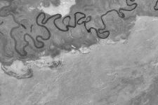
Meandering streams and rivers, like this one in northern Nevada, deposit sediments on the inside edge of the curves. When a loop in the stream/river gets cut off, oxbow lakes result. Places like that are worthy of exploration, since the sediments filling in and cutting off the old channel could contain quicksand and soft mud. Also, when no longer part of the river/stream bed, oxbow lake water levels could drop and/or slowly fill in, exposing mud on the bottom.
In coastal areas, there are mudflats that are exposed during low tide. The mud can be claylike, silty, or sandy. It can be shallow, or deep. However, it can also be deadly in areas, due to incoming tides drowning someone who becomes stuck in the mud. The Alaskan mudflats are a perfect example, where people even drown just be being stuck up to their knees! So, be cautious in coastal mud flats, and perhaps make sure someone else is with you.
Yet other spots to check out are places with clay/silt cliffs where there is ground water seeping out, or streams flowing down. In those areas, part of those cliffs tend to collapse into land/mud slides, with the debris field containing some nice sinking areas. However, you have to be cautious in places where the ground has moved, and probably will move again. You have to inspect the areas, making sure that you aren't at risk of being hit by a falling tree, or of being buried alive.
Well, I hope that you, armed with all this information, will quickly become expert at finding great places! :)
Also, check out some of the descriptions on where to find sinking spots from the
following website:
www.wamsat.com/jthicket/faq.html