The Lorrain Batholith Project - Available for Option to Purchase
The Lorrain Batholith Project - Primary Objective: Diamond
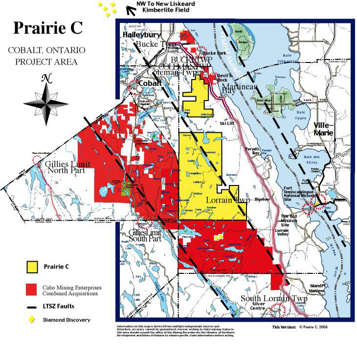
This claim group consists of 232 contiguous claim units
situated
within a 15 sq. mile area from it's southern limit in the 4th
concession of Lorrain Twp in south Temiskaming District, Ontario to
it's northern boundary inclusive of the
8th concession. The claims are boundered in the west by
Gillies Limit - North Part and
Coleman Twps. In the south are the Cabo Mining Enterprises Ltd.,
"Diamond Discovery" and "Boundary Zone" claims which extend to
the northern boundary of the 3rd concession of Lorrain Twp.
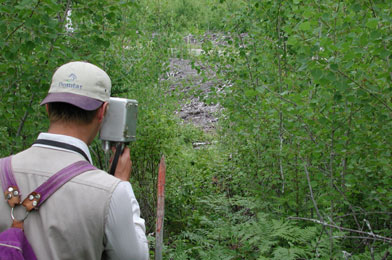
Access is
granted by secondary road to ATV Trails throughout the "Prairie
C" claim group.
These claims are currently under preliminary exploration by Prairie C
for any potential diamond bearing rocks and the project also represents
several priority targets for silver exploration owing to occurrences of
silver noted in the historical record for these claims, the Camp record
at large and more recent discoveries in the area. Staking has
encompassed the majority of
the intrusives including upper and the lower contacts of the diabase
sills which are specifically noted as priority targets for silver where
favourable mineralization is found within 150 metres of the
contact.
These claims are well situated within the Lake Temiskaming
Structural Zone(LTSZ) which is known as host for a large number
of
World Class diamond projects undertaken by a number of noteable
explorers and Public Junior Mining Companies that have significant
claim undertakings that are seeking or developing diamond
projects in South Temiskaming and throughout the region. A key
feature of a number of significant projects within the LTSZ is the
Cross
Lake Fault. Locally, this deep, regional fault transects the entire
"Prairie C"
claim group from the
southeast extent to the northwest extent and is surrounded
predominantly
by The Lorrain Batholith Project claims. The LBP claims
present
numerous conjugate, perpendicular structures relating to the Cross Lake
Fault and such structures are proven to bear diamondiferous
Kimberlite pipes in the
New Liskeard Kimberlite Field. Numerous kimberlites are found within 40
kilometers to the Northwest of
"Prairie C's" holdings and further northwest along the extent
of the Cross Lake Fault within the LTSZ and it's areas of known
and potential diamond
bearing rock which are very encouraging to the Lorrain Batholith
Project(LBP). Further northwest are discoveries near Kirkland Lake and
toward Attawapiskat in the
James Bay Lowlands. which is home to Debeers' diamond development
project
and related
play. Locally, the recent discovery of a kimberlite which was
proven to be
diamondiferous and it's character within a similar geological setting
as offered by the LBP is significant affirmation of our
contentions regarding the data used to assess the LBP claims and therefore
it's positive bearing on the claim geology. We cannot avoid making a comparison to the Lac DeGras Region and it's prolific mine production from Kimberlites found in similar granite greenstone terrain such as offerred by the Lorrain Batholith Project
Close proximity to an area of Keewatin hosted diamondiferous
rock occurrances and diatreme breccias to the immediate south and contiguous to the
project area which is located along a
conjugate structure of the Cross Lake Fault.  A widespread zone of multiphase,
xenolithic
lamprophyre consisting of numerous ultramafic dikes ranging in width
from a few inches to several metres across emerged and to which the full
extent
along strike is not currently known or reported for the 1
kilometre wide by 3 km long area of occurances. Prairie C recovered three diamond fragments
from their first heterolithic lamprophyre discovered during our 2000 season of exploration and mechanical
stripping. A portion of the sample taken "in situ" was determined to be of Minette type
chemistry. This
area has also produced
results of favourable kimberlite indicators from a series of till samplings
conducted by Cabo Mining. Nearly, 600 metres Southwest of Prairie C's Discovery Zone, Cabo recovered approximately 95
diamonds from a drill hole and more from various in situ samples taken later from
distinct locations. The Drill result by Cabo was highlighted in the 2002 Kaiser Report where it was stated; " Cabo's 9 kg Cobalt sample literally screams for a
larger sample and investigation of this rock unit's tonnage potential." Cabo
Mining Enterprises acquired an option to purchase the Prairie C claims
and exercised it's right to purchase in 2004. Cabo Mining states " It is unreasonable to imagine that the only two areas that have been
sampled are the only areas on the Property containing diamonds".
A widespread zone of multiphase,
xenolithic
lamprophyre consisting of numerous ultramafic dikes ranging in width
from a few inches to several metres across emerged and to which the full
extent
along strike is not currently known or reported for the 1
kilometre wide by 3 km long area of occurances. Prairie C recovered three diamond fragments
from their first heterolithic lamprophyre discovered during our 2000 season of exploration and mechanical
stripping. A portion of the sample taken "in situ" was determined to be of Minette type
chemistry. This
area has also produced
results of favourable kimberlite indicators from a series of till samplings
conducted by Cabo Mining. Nearly, 600 metres Southwest of Prairie C's Discovery Zone, Cabo recovered approximately 95
diamonds from a drill hole and more from various in situ samples taken later from
distinct locations. The Drill result by Cabo was highlighted in the 2002 Kaiser Report where it was stated; " Cabo's 9 kg Cobalt sample literally screams for a
larger sample and investigation of this rock unit's tonnage potential." Cabo
Mining Enterprises acquired an option to purchase the Prairie C claims
and exercised it's right to purchase in 2004. Cabo Mining states " It is unreasonable to imagine that the only two areas that have been
sampled are the only areas on the Property containing diamonds".
Faulting and Glaciation
The Lorrain Batholith Project area is transected NWesterly by
the Cross Lake Fault and
staking has encompassed the majority of property surrounding the fault
path. Within this package are contained a number of conjugate
structures already considered highly prospective for kimberlite
discovery based on present and broadly accepted historical data(Sage,
et al). Past
and very recent kimberlite and diamond discoveries on other projects
within
proximity of and structurally related to the Cross Lake Fault have
added further evidence of the importance of these features for pipe
emplacement specifically relating to the Cross Lake Fault and
it's importance as an available deep regional conduit system for
the transport of
diamondiferous material from the mantle to the surface.
Recent Ontario Geological Survey(OGS) reports and industry efforts
seeking to learn
of the presence of Kimberlite Indicator Minerals (KIM) in stream
sediment and glacial till sampling have produced results favourable to
the Lorrain Batholith Project( LBP). To the south and in a down
ice
direction within reasonable transportation distance are found a number
of positive and favourable kimberlite indicator mineral counts.
These
results in general cases are inferred to relate to an up ice source or
in some cases a more local source but if
not yet localized to specific mineral trains that can be spacially
related to a local kimerlite pipe it reasonable to infer that an
up
ice source may be located within the LBP area, at least for a degree of
contribution to those higher counts or could potentially be the source
of the more local findings as it is up ice from
several KIM occurances. This is based on the premise that the
project meets accepted structural
requirements for kimberlite emplacement as Prairie C contends.
Geophysical Summary
Publicly available OGS Geophysical Data and subsequent
correlations
were instrumental in the decision to acquire this land given an
apparent certainty
of it's high potential for diamonds and other mineral occurrances. This
information was related to
topographical and geological analysis which has derived our assertion
that the Lorrain
Batholith Project(LBP) is one of high potential for the discovery
of a well preserved kimberlite with excellent potential to
bear well preserved diamonds. Recent products released by the Ontario
Geological
Society and based on data from the Treasure Hunt Geophysical
Compilation undertaken
by Northern Development and Mines a few years previously have
identified a number of potential kimberlite targets based on the
residual
magnetic intensity data. Pattern recognition techniques(Keating 1995)
were used and the data retained and modeled was 75% and above toward
positive correlation. The results were
depicted in roughly circular anomalies and are described as clusters of
high amplitude solutions. The Lorrain Batholith Project comprises no
less than 24 of these circular features and many relate to previously
known magnetic anomalies that are inferred to relate to key structural
features
also determined apparent from geophysical, geological and terrain data
compilation. 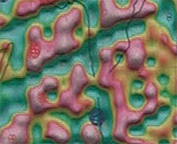
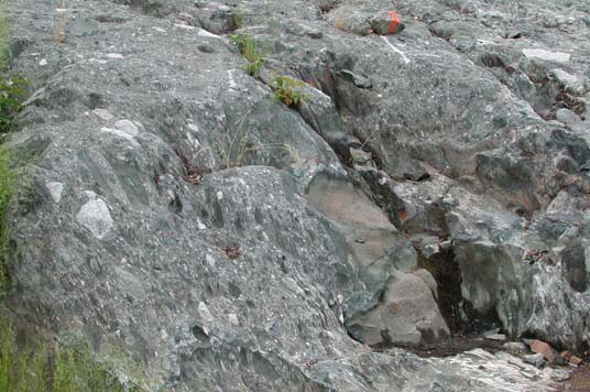
Geological Implications
The most alluring feature of The Lorrain Batholith Project is
it's
geology. The terrain is Archean territory dominated by the largest
claimed portion of the measured, 6 X 9 mile, Lorrain Granite
Batholith.
The Batholith is intruded by Nippissing diabase dikes and sills forming
distinct basins and the NE extent of the Shummann Lake Arch is present
in the northern part of the project area where it and faulting also
intersects the Cross Lake Fault. Shummann Lake to the SW
near the Montreal River Fault is host to favourable KIM results
performed by Cabo Mining. Small portions of the LBP
area are overlain by Huronian sedimentary rock and more
recent sedimentary products in places as well as
some glacial till and erosional products in some low lying areas and
on plateaus in higher regions. Significant relief and
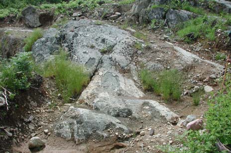
coincidental weathering and exposure exists to locate visible outcrop.
The Fissure Group Claims - Primary Objective: Silver
This property is comprised of typical terrain suited for the
likely discovery of silver and base metals. For a quick review of Silver geology it
is recommended that readers view the Santa Maria Report which
is a compilation of historical activity and contentions relating
to silver exploration during the heyday of Cobalt to more recent
activities of Prairie C. These claims have yet to be fully evaluated
but on
preliminary analysis are deemed worthy of significant attention based
on
historic reports and proximity to the highly prolific, North Cobalt
Mining Camp. Numerous mineral occurances and showings will be
evaluated this season and a preliminary report will be uploaded
as it
become available.
Contact Diamond Corporation http://www.contactdiamond.com/
Arctic Star Diamond Corp. http://www.arcticstardiamond.com/s/Home.asp
Dianor Resources Ltd. http://www.dianor.com
Adroit Resources Inc. http://www.adroitresources.ca/modules.php?op=modload&name=NS-PublicCompany&file=index&page=about.us
Other Relevant Links
Resident Geologist Program http://www.mndm.gov.on.ca/mndm/mines/resgeol/rfe_e.asp
OGS Annual Reports http://www.mndm.gov.on.ca/MNDM/MINES/ims/pub/saleoff_e.asp
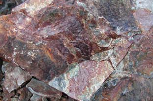
Prairie C has maintained three property groups in and around the Cobalt Camp.The first property group is the Santa Maria claims. These claims are currently vended to Cabo Mining Enterprises Corp and are in the varying exploration stages of their development. Follow the links below to view the Property Reports and Compilation Maps. The second are the Gossan Claims occupying most of the third Concession of Lorrain Twp. Initially explored for base metals they are currently touted as diamond discovery claims resulting from the discovery of 3 diamond fragments in a Heterolithic lamprophyre dike. Third are the Cabo Mining Enterprises Corp Option. This group of claims consisted of grass roots exploration properties as well as 2 former silver/cobalt producing properties. These claims are currently vended to Cabo Mining Enterprises Corp. of Vancouver.
Santa Maria Claims - Vended
The Santa Maria claims were a grass roots exploration project seeking Silver and Cobalt targets associated with typical mineralization and structures, consistant with previous discoveries in the camp. Gold and base metal exploration is also warranted by results of assays from the 2000 work season. An 80 foot wide chert zone in archean host volcanics and a number of typical silver/cobalt targets derived from ground based magnetic survey are featured. Check out the Property Report for more details including property geology and work history. Check most recent press releases for updates on activities.
Prairie C - Property Report for the Santa Maria Mining Claim Group
Project Area Claim Map
Claim Map With Geology
Geological Data Inventory MapSummer 2000 Data
Ground Mag/VLF Interpretation on Claim # L1225263
"Treasure Hunt" Airborne Magnetics of Santa Maria Claim Group
Assay Compilation - Muti Element Analysis and Whole Rock Assay
Learn more about: "Operation Treasure Hunt"The Gossan Claims - Vended
These specific claims occupy a portion of a larger contiguous group of claims in concession 3 of Lorrain Twp. These claims were initially being examined for PGE, VMS and base metal potential associated with the Archean host rocks. The unexpected discovery of a large area of surface occurances of lamprophyre dikes and a unique lamprophyrric breccia similar to those known to bear diamonds in Wawa, Ontario, has added to the significant potential of this claim area. The discovery of 4 macro diamonds and 91 micro diamonds in drill a drill hole conducted by Cabo Mining Enterprises Corp as Cabo Mining has confirmed this potential.Visible occurances appear to meet the structural requirements typical of kimberlites found in the Lake Temiskaming Structural Zone to date. Data compilation is currently underway and will be provided here, as it becomes available. View Photos in Rocks and Minerals section.
"Treasure Hunt" Airborne Magnetics for Lorrain Twp Claim Area
MNDM Claim Map G - 3438 Concessions I - III
Assay Compilation - Multi Element Analysis and Whole Rock Assay
Cabo Mining Enterprises Corp - Cobalt Project
This significant undertaking by the Vancouver junior is a grass roots exploration project looking for VMS (Volcanogenic Massive Sulphide) type deposits and base metal sulphides associated with the keewatin volcanics and the various sedimentary rocks of the area such as Keewatin and Huronian sediments. Silver and cobalt targets are being sought as well. Recent results from drillng into a volcanic breccia associated with known lamprophyres has yielded 95 diamonds from a 4.6 metre intersection. This confirms previous diamond results achieved by Prairie C in the area and also confirms this exciting new potential.
View Cabo Mining Enterprises Corp's Land Position in :
Gillies Limit - North Part and South Part, Lorrain, South Lorrain,Coleman and Bucke Townships
The project includes a large contiguous block of claims including other properties originally optioned from Prairie C and Outcrop Explorations Limited by Branchwater Resources Limited of Calgary.These claims are vended to Cabo Mining Enterprises Corp. Contiguous claims are located in Gillies Limit North and South Parts, Lorrain and South Lorrain and Coleman Townships. Additional claims are held in Bucke Township. More information about these agreements and other activities may be obtained from the
Sedar Database - Search for Public Company DocumentsCabo Mining Corp - Cobalt Area Geology Report - (Microsoft Word Doc)
Author: John A. Nicholson P. GeoSummary Work Report - 2000 Exploration Season - Cobalt Properties
Author: Seymour Sears BA, BSc
Use your back button to exit maps!
N.B. - Compilation Maps and informational graphics, exept where otherwise indicated were produced by and are the property of Prairie C. They have been provided for viewing purposes and no other use or publication may be authorized except with the express written permission of Prairie C or it's partners. Graphics were produced from data derived from multiple sources and accuracy may not be guaranteed. Information contained in these graphics should be verified prior to making any interpretations or deriving any conclusion from them. Anyone wishing printed or printable versions of these graphics may contact us directly. Anyone wishing to stake claims in the area should first check with the Ministry of Northern Development and Mines regarding the status of claims.
Home
About
Prairie C About
This Page The
Cobalt Camp Prairie
C Properties
Contact
Us Links
What's
New ! Geological
Potpourri Hey!
Rockhounds
Compilation
Mapping Project - The Cobalt Camp
Ontario
Geology Map