How to get there:
[From Ottawa] [From Kingston] [From Montréal] [Environment Canada Weather] [MapBlast!]
From Ottawa:
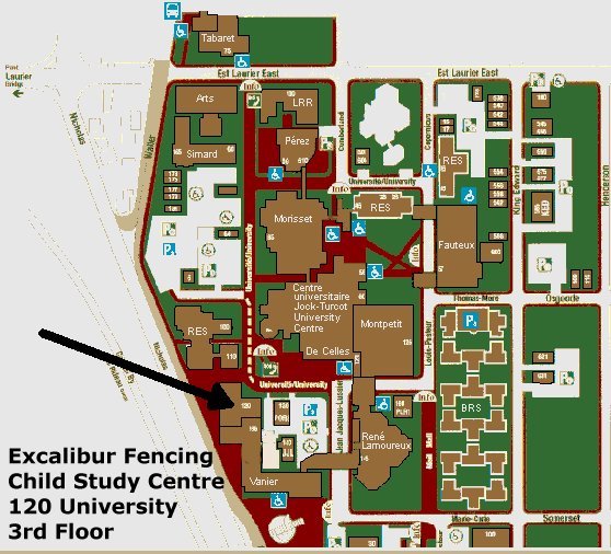
The competition will be held in the fencing salle of the Excalibur Fencing Club. The salle is located in the "Child Study Centre" Building on the campus of the University of Ottawa. The address is 120 University Street, 3rd Floor. Parking is available adjacent to the building in parking lot "X It will cost you $3 per day to park there on a weekend day.
The university campus is encircled by a number of major thoroughfares, which makes it very easy to find. These include King Edward Avenue on the west, the Rideau Canal on the east, the Queensway on the southern edge of the campus, and Laurier Avenue on the north.
From Kingston:
Zip out of Kingston east on Highway #401 and then travel northeast on Highway #15 towards Smiths Falls. Continue through on #15 past Smith Falls towards Carleton Place and get on to the Queensway (Highway #417).
Follow the Queensway into Ottawa and look for the "Lees / Mann" Exit. Take this exit and turn left on Lees. Drive past Algonquin College and over the Queensway on the overpass. This road will take you straight to the southwest corner of campus, and will link up to King Edward Avenue. Drive up the hill on King Edward Avenue and turn left into campus at the first set of lights. This would be the intersection of King Edward and Somerset East/Marie Curie. You will see a restaurant named "Coyotes" at this corner. Follow Marie Curie into the campus, turning right at the corner, and then left into parking lot "X" (see map).
From Montréal:
Drive west out of Montreal on Route 40 towards Ottawa, and connect on to Route 417. Once you get close to the National Capital, start looking for a few key exits. The one you will turn off on will be "Nicolas/Mann", which is one exit past the "Vanier Parkway/Riverside Drive" exit. Take the "Nicolas/Mann" exit and stay in the right lane, going towards Mann Ave. Keep on going straight and cross over Mann Avenue. At this point you will be on King Edward Avenue. Drive up the hill on King Edward and turn left into campus at the first set of lights. This would be the intersection of King Edward and Somerset East/Marie Curie. You will see a restaurant named "Coyotes" at this corner. Follow Marie Curie into the campus, turning right at the corner, and then left into parking lot "X" (see map).
If you get lost on the way, phone Don Lane at (613) 799-8812.
Go to the
Environment Canada web site and see how nice a day it'll be in our area. We've never
had to cancel a tournament yet!
Weather Information:
MapBlast! - a map-generation website:
You can also create your own map to the National Capital region by going to MapBlast! Once at the site, go to the Canadian Cities section, type in "Ottawa, ON", then click on the button. You can modify the map's scale by clicking on different vertical points of the ruler that is beside the map. Move the map around by clicking on a new area on the map. It is easy to generate a new map with a geographic centre based on your newly clicked upon position. Have fun, and put a bookmark on the site - it is a keeper!

Beam me back Challenge de Fer central