|
76.08 miles, 8:56. Maximum 34 mph, rating: 7
Last night we shared Pauline’s hospitality with a couple from Missouri, south of St Louis, and their two daughters. Pauline served us a big pancake breakfast, and gave us nice little souvenir pins of Soo.
We discussed her plate collection. Paid her, but forgot to thank her for doing our laundry yesterday. The B&B had some disadvantages – one bathroom for six people, two days per towel, tying the bikes in the garage – but it sure beat another look-alike motel room, and saved some money.
B&B people outside California haven’t yet sold their marketplace on the idea that they’re a cut above the motels. Consequently, they tend to charge very reasonable rates, at most competitive with motels, and frequently less.
We left Highway 17 at Echo bay to try the side roads. This was a superb idea in Minnesota, a disaster in northern Ontario. The road was bad and very hilly. Our maps blithely asserted the roads were paved – wrong!
We stopped for a snack at Leeburn. The woman said another cyclist had been through a week before, and camped there. Then we rode a long and difficult stretch of sand road past Rock lake back to 17. The rain just rounded off our discomfort. We lunched at Bruce Mines. All this builds character, I suppose.
Scenario: little kid on a little bike at Rock lake. Larger (but still little) kid running behind, pushing the bike. Neither kid was wearing a shirt. But the small one was riding with his pants down, bare-ass. I still haven’t figured that one out.
Shortly after we left Bruce Mines, it stopped raining, and we got a pretty good road and a tailwind. Nevertheless, we were ready to pack it in at Iron Bridge at 4 PM. Iron Bridge is misnamed – the bridge is really steel. Ate dried apricots on the lawn of one motel, then checked into another with a river dock. Ate out of the grocery store. Slept three hours, went out for a beer. Then we strolled down and enjoyed the night and the water and the bridge.
Road quality is mixed. Sections with no paved shoulder are pretty stressful. The one good thing about our side roads venture was that there was no traffic. This country is clearly still in the Empty Quarter. The land is mostly unused, with a few hayfields and some cattle grazing in the fields.
82.97 miles. Maximum 30 mph, rating: 8
Busses in northern Ontario are all Greyhounds. I don’t think we saw any Voyageurs until Sault Ste Marie.
It was cold (40°F!) this morning, with clear skies and fog near the rivers. We ate a first breakfast in the motel, and got started early enough to see the sun projecting its rays horizontally, silhouetting trees, casting shadows into the fog. The heavy dew on the grass looked like frost. The usual noisy crows and a loon or a duck. Lake Lauzon was gorgeous and had some pleasant resorts on it.
The day came on clear and cool, with easy terrain and good road (both the surface and the shoulder). There’s a light tailwind, and it looks like a good day. We met about eight unloaded cyclists going west. One looked like a real bikie, and was well in the lead. One (there’s always one!) wore a helmet with the straps undone. Like buying insurance and not bothering to pay the premiums!
We lunched at a picnic stop at Serpent river. It was a great scene. The river loses about 20' of elevation in three rapids, with pools, narrows, exposed rock, gravel. There’s a wide river valley with steep sides, grown with trees and ferns.
We stopped in Massey for raisins, and Dave visited the tourist information stand. They said it was hilly south of Espanola. We stopped again in Webbwood for root beers. The young French Canadian waitress asked for advice on getting into cycling, but admitted that her parents wouldn’t let her ride on the highway.
We got to Espanola nine miles and several hills later. Still had a good wind. Big threatening cloud. Checked into an expensive motel. Decided to stay here, although the original idea had been to go on to Little Current. The town is 6000 people, nothing special. There’s some smell from the EB Eddy paper mill here. Walked around the paper mill and residential areas (steep roofs), bypassed the country club because of the dress code. Stopped for groceries. We watched an Irish setter cross the highway several times, oblivious but unscathed, thanks to considerate drivers. Ate pizza and beer across from the motel.
A good, fast day.
Slept 5:30 to 7:30. Watched the Expos play the Giants on French language TV, and ate brownies.
74.39 miles. Maximum 33 mph, rating: 9 Map
Ate raspberry turnovers and grapefruit (very sour!) in the room. Left before 7.
1:45 PM, South Baymouth
Another cold morning, clear and crisp. Some early truck traffic proved atypical, and most of the day was on quiet road. A tremendous relief to be off the Trans-Canada highway, and away from the trucks.
Riding assertively
For the last few days, at Jacky’s suggestion, I have been riding a couple of feet out into the road. This prevents cars from passing at high speed without crossing the yellow line. We’ve noticed that a driver, once he gets across the yellow line, tends to give us plenty of room. You just have to get him across the line in the first place.
When there’s oncoming traffic, cars coming up behind slow down. When they’re suitably slow, we move over so they can pass in the lane. All of this presupposes a rear-view mirror, of course!
This seems to work quite well, except for the big transport trucks, which negotiate with noise and naked fear!
I was concerned that 70-75 miles of hilly terrain couldn’t be done by 5 PM to catch the 5:30 ferry. Started out very hilly – my average was 8.3 mph after 5 miles. So I started pushing it on both the downhills and uphills, and got it up to 9.7 by 10 miles.
Dave stopped at Whitefish Falls for coffee, but I kept plugging. Beat him to Birch Island by a couple of minutes, and read about FDR’s fishing trip in 1943, before the ‘historic Quebec conference.’ Beautiful quartz monument.
The terrain flattened out, and we got a tailwind. By 10 AM, we were doing fine and stopped for a hot breakfast at Little Current, the first town on Manitoulin Island.
There’s a drawbridge to get to the island – sign says it’s open for fifteen minutes on the hour, but we didn’t stop to watch it. Saw two lightly-loaded bike tourists in Little Current, and caught up with them at a scenic lookout later. They were from Toronto, on their way home. They had left their car at Tobermory (we discovered later), and had only gone as far as Little Current.
The road was good, and the wind moderate, mostly tailing. We stopped at the High Falls, which were dry. It would have been a pretty place were it only wet.
Not knowing exactly how far it was (I figured it was less than 50 km), I bet Jacky I could get to South Baymouth in less than an hour and a half. In an extended push, I covered the 24 miles in 1:14:28. Not a bad rate, loaded for touring! The country was flat, with a few rollers.
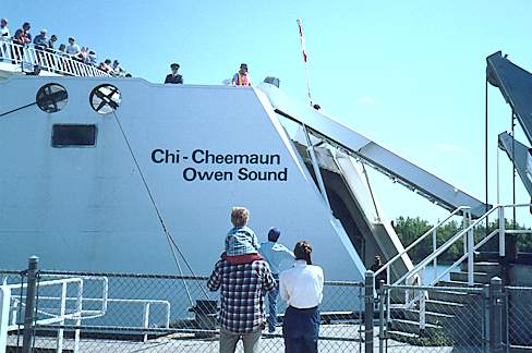
I was there in time to have caught the 1:30 ferry, and took pictures of the Chi-Cheemaun (means Big Canoe), loading and sailing away, to prove it.
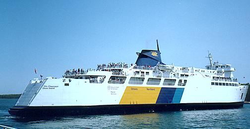
This is South Baymouth cove, just around behind the ferry terminal.
5:00 PM
Jacky and the other tourists showed up. It turned out the guy had been on an eleven-country tour of Europe, but his bike and all his gear had been stolen in Cannes. So instead of Europe, he was near home in Ontario, doing some less ambitious touring.
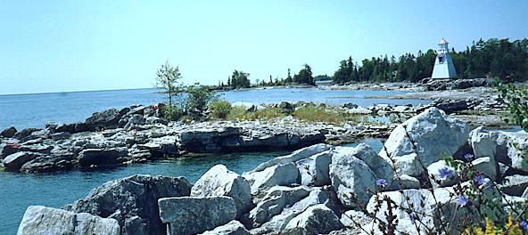
We went to the museum and one-room school in South Baymouth. The 3:40 ferry, the Nindawayma, was late. From the ferry, we had beautiful views of the shoreline and the sound. The boat had been sold into Canada from some Scandanavian prior life, and some of the stencilled messages were in a Scandanavian language. The name of the boat had been painted over. I tried, but failed, to make out its previous identity.
We eavesdropped on a conversation on the ferry. The protagonist was an 81-year old man, off on vacation by himself. The other party was a nurse, who had apparently cared for the man’s wife in years past.
We stopped for ice cream at Tobermory, to see the little waterfront area and let the ferry traffic clear out. Then we found the campground. We ate chicken and fish at an overpriced restaurant next to the campground. Full moon tonight.
71.62 miles. Maximum 34 mph, rating: 6
Full moon still there, but clear in the north. Last night, it rose in the south, as the sun set in the west. Cold! We packed up and left without eating. Stopped at another campground, hoping their restaurant was open. It wasn’t, but we saw two camels!
10:00 AM, Ferndale
[We crossed 45°N latitude once again, heading south. Didn’t notice.]
Another cold (45°F) clear start to a pleasant sunny day. We stopped for breakfast at a family-operated restaurant a few kilometers south of Tobermory. The family was all there, getting ready for the day. The proprietor was teaching his son (about ten years old) to wait tables. A pretty 4-year-old girl was all dolled up to have her picture taken at the day care center today. Nice people; we talked with them for quite a while.
There’s a headwind as we go south. The traffic is light, and it’s a relaxing ride.
12:20, Wiarton
The clot of ferry traffic passed with only minor hassle. The headwind is turning it into a difficult day. We’ve seen half a dozen cyclists so far, in ones and twos, from half-loaded tourists to unloaded sportists. The most painful sight was the pair with rear panniers and full backpacks! At least they had a tailwind.
Wiarton is a pleasant little town at the base of the escarpment. (This whole escarpment thing seems overblown – it’s only 100-200' high. If it weren’t so consistent, and so visible, it would just be another hill. You can tell I’m not a geologist!)
We stopped for OJ at Becker’s and had a picnic lunch at the Wiarton park, sited on beautiful Colpoy bay.
7:00 PM, Owen Sound
The traffic was building up to nuisance level, so we took to the side roads yet once again. Highway 1 was a poor road, with about 1 km of construction, and we had a strong headwind into Kemble. Another New England-style stone fence.
At Kemble, we had root beers to cheer us up, then headed south with a better road and a better wind. We were reminded of Foothill road near Pleasanton and some of the nice homes on large lots near Walnut Creek.
Once we reached Balmy beach, the road improved and ran right along the lakeshore into Owen Sound.
I passed two tractors pulling carts of firewood. The old man on the front tractor was oblivious, but the teen-agers running the back rig thought it was pretty neat to be passed by a bicycle!
Summer folk festival going on at the harbor. Tents practically on top of each other at the campground.
We stayed at the Company motel downtown. Not much of a place, but everything else was booked for the weekend. We had to grunt our bikes to the second floor without an elevator. Not bad going up, but difficult and dangerous coming down.
Owen Sound is a nice town, prosperous and lively. They have parking lots on the next street over from the main drag, and there are buildings and businesses between the parking lots. There are also lots of walkways from the parking lots to the main street. This results in quite a bit of diversity and complexity from a pedestrian viewpoint.
We ate at a place with a Greek name; it turned out not to have Greek food. BBQ ribs instead.