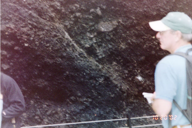
<--Fault or Scarp
Troutdale ---->
Formation
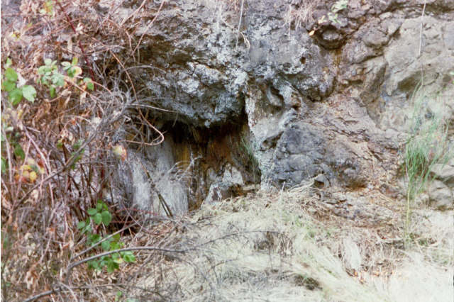
Tree Stump in Pillow Lava
Back to My School Work Page
<------Troutdale Conglomerate
Geological Field Trip Road Log Page 2 11:12 am Washington Park Mile 12.4 Robertson Tunnel (-350 ft from the surface) A core sample was taken in 1992 when construction of the Max line to Hillsboro was started. The sample has been displayed in the tunnel with the different layers of soil labeled. Elevation at surface 710�. Vantage Horizon Slide under Zoo, Forestry center and Vietnam Memorial. Surface - 25' Portland Hill Silt - 25' - 46' Boring Lava - Normal Polarity - 260,000 years ago 47' - 71' Portland Hill Silt 260,000 to 860,000 years ago 72' - 110' Boring Lava - Normal Polarity 111' - 116' Portland Hill Silt 117' - 141' Boring Lava of Cornell Mountain - Reverse Polarity - 960,000 years ago 142' - 184' Portland Hills Silt 960,000 to 3 mya 185 - 221' Wanapum Basalt Formation 12 mya - 500 cubic miles of lava in a single flow 222' - 223' Vantage Horizon 15.6 mya Weathered deposits 224' - 257' Sentinel Bluffs Flow of the Grand Rhonde Basalt Formation - 500 cubic miles lava flows - 2 of 120 separate flows, Winter Water and Sentinel Bluffs. Most extensive basalt flows on Earth. From Idaho 257' - 280' Grand Rhonde - Winter Water Flow 12:15 pm Water Reservoir The water reservoir had to be stabilized after it has moved downhill because the silt, alone, could not support the weight of the contained water. 1:55 pm Mt. Tabor Mile 21.5 Cinder cone on shield volcano. Scoria and tephra are present in the dug out area. Evidence of a fault or scarp is visible. Mt. Tabor was submerged in the Missoula Floods.
2:45 pm Carver Mile 37.2 Sandy River Mudstone deposits with Troutdale formation. Troutdale formation is a true conglomerate, Cascadian Facies of Troutdale formation deposited over 1 mya. Troutdale formation is a water laid deposit, not well sorted. Boring Lava overlays Troutdale conglomerate up to 150� of Troutdale formation. BORING LAVA TROUTDALE CONGLOMERATE SANDY RIVER MUDSTONE
3:18 pm I-205 Mile 48.6 15 million years old tree stump survived in pillow lava formation. It was probably in a swamp, when the lava hit the swamp water, cooled and encapsulated the tree stump, while burning the rest of the tree.
3:40 pm Sylvania Campus of Portland Community College Mile 62.1 End of Road trip I have discovered that Portland has a lot more geology formation and history than I ever expected. While I am sure that everywhere has their own geologic history, I am glad that I have not only learned more about Portland geology, but that I also was able to physically experience it myself. Although, the media, has taken the time to tell the public about the probability of strong earthquake in Portland, learning that the reason why parts of Portland are more vulnerable to damage has opened my eyes to view the actions that the government has to rectify the vulnerabilities in the region. The West Hills of Portland are not only vulnerable to landslides due to the deposits of Portland Hills Silt, but this also makes them very vulnerable to earthquakes, because the hills absorb water and then when they are shaken by an earthquake the water separates, therefore a landslide would be probable effect of an earthquake. The idea of pillow lava actually existing in Portland was probably the most surprising formation that I witnessed. I have always associated pillow lava with Hawaii, not with Oregon. I am not sure that I would have ever believed that it actually exists in Portland if I had not seen it for myself.