This free website is sponsored by advertisers. We do not have control over any ads that may appear while viewing this page, nor do we necessarily endorse the sponsors. |
|
|
|
|
This free website is sponsored by advertisers. We do not have control over any ads that may appear while viewing this page, nor do we necessarily endorse the sponsors. |
|
|
|
|
This page serves as both a timeline to show the known history of the effort to name Headwaters Hill - as well as an index to related articles, so you can read what others have said about Headwaters Hill.
George Sibley is on the Geography faculty at Western State College
in Gunnison, Colorado, and is in charge of the Headwaters Regional Studies Program
there. He independently "discovered" the significance of "Point 11,862" a few
years before I did. His first hike to its summit was in 1995, and it was at
that time he began referring to the mountain by our proposed name of "Headwaters
Hill". Click here to view the Headwaters
Hill page at his Western State College website.
(If the link above no longer goes to an active page, click here instead to view
a copy I downloaded to my server. Keep in mind that
any links on that page will not be functional.)
Colorado Central Magazine - published by Ed Quillen of Salida,
Colorado - deals primarily with issues relevant to residents of an area in Colorado
which happens to surround Headwaters Hill. In the December 1995 issue, this
article by Sibley was printed therein.
(If the link above no longer goes to an active page, click here instead to view
a copy I downloaded to my server. Keep in mind
that any links on that page will not be functional.)
I climbed Mt. Elbert with some family members. At 14,440 feet above sea level, it's Colorado's highest peak. I was glad to be able to say I've been there - but afterwards, as I wondered where to go for my next hike, I began to think that maybe there are other reasons to climb a mountain besides its height. So I began looking for peaks that were significant in other ways. That's how I became interested in "triple divides" - and that's how I "discovered" the geographical significance of "Point 11,862". I was astounded to find that the mountain didn't have a name, and I began investigating how an official name gets conferred upon a landform. Click here for more details on how I found this mountain.
I figured if I was going to submit a name for "Point 11,862", I ought to be able to say I've been there! So I talked my father and my backpacking buddies into going for a hike with me. Click here to "virtually" go along on that hike to Headwaters Hill: view several maps, and some photos we took on a typical beautiful fall day in Colorado.
I posted photos and maps of Headwaters Hill at this website (although at first, since I had not yet met anyone else who knew about "Point 11,862", I advocated the name "Three River Point" for this mountain). You've probably already viewed the main page for "Naming Headwaters Hill".
This column
by Ed Quillen appeared in the Denver Post on May 4, 1999. While it doesn't
specifically mention "Headwaters Hill", it does refer to the Closed Basin, into
which Headwaters Hill drains. I don't even subscribe to the Post, but my alert
father happened to read it, and thought it might interest me. He was right -
I had never even heard of the Closed Basin before then. I e-mailed Quillen to
ask him some questions about it. As it turned out, of course, he was already
well aware of Headwaters Hill, and he put me in touch with George Sibley. If
I had never read this article - and, as a result, met these two men - I suspect
that my efforts to name Headwaters Hill would've never made it this far.
(If the link above no longer goes to an active page, click here instead to view
a copy I downloaded to my server. Keep
in mind that any links on that page will not be functional.)
After Ed Quillen and I became acquainted, he printed this
article in the June 1999 issue of his magazine.
(If the link above no longer goes to an active page, click here instead to view
a copy I downloaded to my server. Keep in
mind that any links on that page will not be functional.)
Ever since George Sibley "discovered" Headwaters Hill, he has
led his students on a hike to its summit each fall. In October 1999, Quillen
printed in Colorado Central magazine this
article by Sibley about the upcoming hike - and about naming the mountain.
(If the link above no longer goes to an active page, click here instead to view
a copy I downloaded to my server. Keep in mind
that any links on that page will not be functional.)
Ed Quillen devoted his November 21, 1999, column
in the Denver Post to the naming of Headwaters Hill.
(If the link above no longer goes to an active page, click here instead to view
a copy I downloaded to my server.
Keep in mind that any links on that page will not be functional.)
In this
article, Quillen informed his Colorado Central readers about the latest
developments in the quest to name Headwaters Hill.
(If the link above no longer goes to an active page, click here instead to view
a copy I downloaded to my server. Keep in
mind that any links on that page will not be functional.)
Grace Nugent (one of Sibley's students) adopted our effort, and incorporated it into her studies. She sent our proposal to the Saguache County commissioners, and to the supervisors of the three National Forests whose boundaries meet at the summit of Headwaters Hill. Sibley and Quillen also circulated a "petition" among local residents, in order to ascertain the level of local support for our proposal.
I compiled all of the research, maps, photos, and documentation done by everyone involved, and mailed it in - along with an official application - to the U.S. Board on Geographic Names.
At their meeting on this date, the U.S. Board on Geographic Names voted favorably on our proposal... and the little mountain now is officially named "Headwaters Hill"! Shortly thereafter, an entry for "Headwaters Hill" was added to GNIS (the online geographic names database administered by USBGN). That's a great accomplishment, and a very important milestone.
However, it remains to be seen how long it will take before Headwaters Hill begins showing on up actual maps. Apparently USGS is no longer updating its paper topographic maps, so there may never be a reprinting of the "Chester" quadrangle that includes a label for Headwaters Hill. This is unfortunate, because professional cartographers often use USGS topos as a source for their maps. Without that, it's hard to say whether mapmakers will become aware of the existence of Headwaters Hill.
While at the annual NACIS map conference, I met a cartographer who works on National Geographic/Trails Illustrated maps. I had seen their "La Garita - Cochetopa Hills" map, and I knew Headwaters Hill was not labeled on it. So I gave him the details on where the mountain is located.
This was a good year for Headwaters Hill. In August I purchased a brand-new, first-edition copy of Benchmark's atlas of Colorado, and was very pleased to find Headwaters Hill labeled on the map!
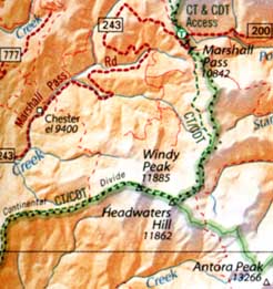 from Benchmark's "Colorado Road and Recreation Atlas"
I asked them how they knew about Headwaters Hill, and I learned that they extracted their geographic name labels from the GNIS database. Then, in October, my colleague who works for National Geographic showed me the latest edition of their Trails Illustrated "La Garita - Cochetopa Hills" map, which now includes a label for Headwaters Hill:
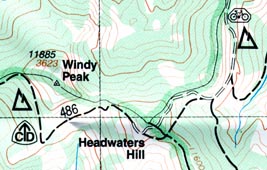 from National Geographic/Trails Illustrated's "La Garita - Cochetopa Hills"
map
from National Geographic/Trails Illustrated's "La Garita - Cochetopa Hills"
map
To the best of my knowledge, these were the first commercially-printed maps to show Headwaters Hill - congratulations to Benchmark and National Geographic. This represents a big step towards the increase of public awareness about this special mountain... and that's what it's all about for me, ever since I learned about this triple-divide peak back in 1997.
2008
Because many online map providers use the GNIS to automatically locate and label landforms, Headwaters Hill can now be viewed on a growing number of online maps. At the time of this writing, I personally believe Google Maps is the most robust and well-implemented:
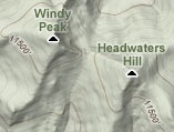 2008 screen shot from Google Maps, "Terrain" view
|
|
|
| To feedback form... | |
Questions? Comments? Broken links? E-mail us at [email protected]
|
|
Page last updated 13 May 2008. |
|