Overview
Capital: Basco
Land Area: 230 square kilometers
No.of Towns: 6
Location: 20' 30� North Latitude, 121' 50� East Longitude
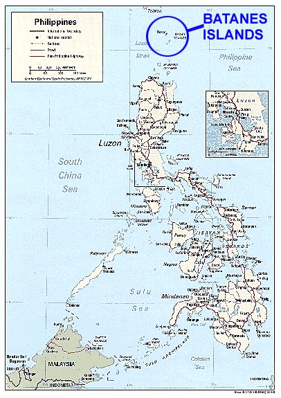
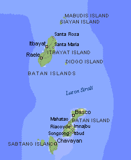
Batanes, the smallest province in the Philippines in terms of population and land area consists of ten tiny islands and islets located about 162 kms. north of the Luzon mainland. Of this island group, the largest and most economically important are Itbayat, Batan and Sabtang. Five islets, namely, Siayan, Mavudis, Diogo, North Island and Y'ami form the northernmost frontier of the Philippine archipelago, Farther north, only 46 miles away from Y'ami is the southernmost tip of Taiwan. Two islets, Ivuhos and Dequey are situated south west of Sabtang.
Almost one-half of Batanes are hills and mountains. Batan island, with a land area of 35sq. kms., is generally mountainous on the north and southeast. It has a basin in the interior. Itbayat Island, which has a total area of 95 sq. kms., slopes gradually to the west, being mountainous and hilly along its northern, eastern coast. As for Sabtang, mountains cover the central part of its 41 sq. km. area, making the island slope outward to the coast.
The islands are situated between the vast expanse of the waters of Bashi Channel and Balintang Channel, where the Pacific Ocean, merges with the China Sea. The area is a sealane between the Philippines and Japan, China, Hongkong and Taiwan. It is rich with marine resources, including the rarest sea corals in the world.
Toward the end of the Spanish regime, Batanes was made a part of Cagayan. In 1909, however , the American authorities organized it into an independent province. Because of its strategic location, the Batanes island group was one of the first points occupied by the invading Japanese imperial forces at the outbreak of the Pacific War.
The Batanes Islands are a special place. Isolated from the rest of the country by miles of rough ocean, they have evolved into a truly unique destination - unlike any other island in the Philippine archipelago. The land is different - windswept hills and boulder-hemmed shores that lure, challenge and haunt. The people are different - a brave and skillful race of hardy, inscrutable survivors. The weather is different. In fact, the weather is king. Everyone and everything steps aside. The houses are different - stone walls, whitened with lime and roofed in thatch. The boats, the language, the crafts, the wine - all different.
These islands have been compared to New Zealand, Ireland and the Scottish Highlands. They are not typically tropical. For some, they are a little too laid back, a little too unpredictable. The best laid travel plans have a way of going awry on these islands. So, you must make time for the Batanes. An Ivatan once said: "When you're on the Batanes, enjoy the Batanes. Don't worry about getting home". These islands grow on you, but you must wait and watch for your rewards - not a bad lesson for those of us who are sure we are the center of the universe. Once touched, you learn to enjoy the timelessness of these islands. For you, life can never be the same again. You know you'll return someday.
The total area of Batanes is estimated at 23,000 hectares (230 square kilometers), a size that is only a third of that Metro Manila. Batan, Itbayat, and Sabtang islands make up 90 percent of the province's land area. They are likewise the only inhabited ones. The rest of the province consists of the islands of Duquey, Ivuhos, Mavudis, Diogo, North Island and Y'ami. Ivuhos and Mavudis, while unpopulated, are used as communal pasture areas by residents of nearby Sabtang Island.
Municipality |
Area (Has.) |
Percent Share |
|---|---|---|
Basco |
3,550 |
15.43% |
Mahatao |
1,290 |
5.61% |
Ivana |
1,180 |
5.13% |
Uyugan |
1,550 |
6.74% |
Sabtang |
4,070 |
17.70% |
Itbayat |
9,290 |
40.39% |
Islets |
2,070 |
9.00% |
Topography

The province is hilly and mountainous, with only 1,631.50 hectares or 7.10% of its area level to undulating and 78.20% or 17,994.40 hectares varying in terms from rolling to steep and very steep. Forty two percent (42%) or 9,734.40 hectares are steep to very steep land.
Because of the terrain of the province, drainage is good and prolonged flooding is non-existent. The main island of Batan has the largest share of level and nearly level lands, followed by Itbayat and Sabtang, respectively. Itbayat has gently rolling hills and nearly level areas on semi-plateaus surrounded by continuous massive cliffs rising from 20-70 meters above sea level, with no shorelines. Sabtang on the other hand, has its small flat areas spread sporadically on its coasts, while its interior is dominated by steep mountains and deep canyons. Batan Island and Sabtang have intermittent stretches of sandy beaches and rocky shorelines.
The terrain of the province while picturesque at almost every turn, has limited the potential for expansion of agriculture in an already very small province.
Climate
The province is constantly swept by wind and rain, but the notion that it is battered by typhoons is wrong. If Batanes is always mentioned in connection with weather disturbances, it is because its capital, Basco, holds the last weather station in the north. It is a reference point for all typhoons that enter the Philippine area of responsibility. It has no pronounced wet or dry season. It is almost always raining, from the minimum of eight days to a maximum of 21 days a month. It enjoys practically four seasons, the best ones being summer (April-June) and winter (December-February), when the temperature dips as low as seven degrees centigrade.
The best time to visit is mid-March to June. An Indian summer supposedly takes place in September. Sometimes, the weather is nice as early as February and as late as July. North or east winds bring in cooler air. They also bring in weather fronts and cloud build-ups that could cause flight cancellations. An indian summer supposedly takes place around September. Cool weather - a phenomenon Ivatans like to call winter - prevails from December to February. When dealing with Batanes, always remember that, on these islands, the weather often changes suddenly. Just be ready for whatever follows your way.
Typhoons
Batanes lies in a typhoon path. It has been observed that typhoons could occur in any month, although they are most regular and frequent in June to September, with October to November sometimes experiencing extended stormy weather. In 1991, a total of 13 typhoons passed Batanes, 12 occuring from June to September and one in March. Seven of these occurred in August. These tropical storms blow in the general direction of Northwest and North Northwest from the Pacific Ocean to Taiwan and Japan and occur due to tropical cyclones that originate from the Pacific Ocean.
While typhoons can occur in any month, the data points to their clustering is August. Thus, the notion that the islands are completely inaccessible due to typhoons for six months should be corrected.
People
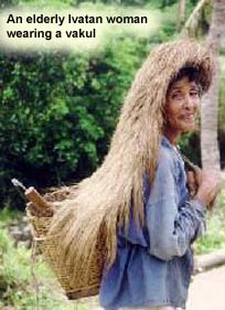
The natives of Batanes, the Ivatans, a sturdy, self-sufficient people with a very strong sense of community. These people trace their roots to prehistoric Formosan immigrants and latter-day Spanish conquistadors. Being out off from Luzon mainland, the Ivatan is of comparatively purer stock. They bear the features of their ancients; the Spaniards aquiline nose and the Formosan's almond eyes. The Ivatan lie in communities of stone houses laid out along narrow streets that follow the contour of the land. Completely impregnable, these houses can withstand the wind velocity that on bad days could beat the barometers mark. As added precaution during a typhoon, the Ivatan secure homes with a rope net. They do the same for their farm plots to protect their crops of yam and garlic. This insular character is. of course, more apparent in the Ivatan community. There are no movie houses, no markets, and no shopping centers. Newspaper is available only on flight days.
Food
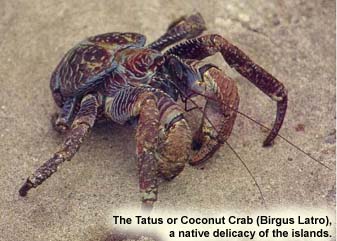
Ivatan dishes use ingredients that are rich and unusual. During the off season, however, fresh food can be scaree and hot meals can be expensive. If you plan to visit during these months, and are not part of a package tour, bring alone some basic canned goods. Cows and goats are grazed extensively on the islands. Garlic is a leading export, second the cattle. Root crops such as camote (sweet potato) gabi and a unique variety of white ube, are raised for local consumpsion - especially in the lean months. Sugar cane is cultivated to produce the heady Ivatan brew, palek. From March to May, fish and seafood are available. Dorado (arayo) and Spanish mackerel (tanigi) are favorite summer catches. They are eaten fresh or salted for consumption during the typhoon months. Flying fish (dibang) is also a local specialty. Coconut crab (tatus), spiny lobster (payi), helmet urchins (unot), that can be enjoyed when available. Salads and vegetables dishes are made from fern fronds (pak o), heart of banana or dips with your food - bring your own, Batanes food is simple food. Unless you have brought your own food are ready to help in the kitchen, don't expect to be served gourmet meals.
Language
Ivatans still use their Austronesian language, peppered with pidgin Spanish and spoken with the musicality of Chinese. Ivatan is spoken on the islands of Batan and Sabtang. Ichbayaten is spoken in Itbayat. English and Tagalog are widely spoken and understood by Ivatans, 95% of whom are literate.
Economy
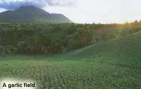
About 75% of the Ivatans are farmers and fishermen. The rest are employed in the government and services sector. Garlic and cattle are major cash crops. They also plant camote or sweet potato, cassava, gabi or tuber and a unique variety of white uvi. Sugarcane is raised to produce palek, a kind of native wine, and vinegar.
In recent years, fish cath has declined due to the absence of technical know-how to improve the fishermen's catch. Employment oppotunities are scarce. Most of the educated Ivatans have migrated to urban centers or have gone abroad.
Distance and bad weather work against its economic growth. Certain commodities like rice, soft drinks, and gasoline carry a 75% to 100% mark-up over Manila retail prices.
Education
Batanes has a literacy of 95% higher than the national average of 93%. Elementary and high school education are free. Teacher to student ratio is 1:17 for elementary and 1:13 for secondary levels.
There are 19 elementary schools, 11 of which offer complete courses from grades one to six. There are secondary schools in all six of the municipalities. The comprehensive national high school is located in Basco and formerly has a branch in Mahatao and Ivana which later became independent and separate schools.
There is a school of fisheries in Sabtang, the Batanes Polytechnic College in Basco, with a branch in Uyugan, while an agricultural high school has been put up in Itbayat.
St. Dominic College in Basco is the only tertiary school. It offers vocational courses, baccalaureate courses in arts, commerce and education, and recently, graduate course in education.
Philippine Province of Batanes
Copyright © 2001
Jerry C. Naldo
Somewhere in the Philippines