Brad's Roadtrip of June 21, 1999
On the 21st of June, 1999, I went on a small road trip covering about 150km / 90 miles from my parent's home in Casula (about 35km / 22 miles SW of Sydney) to Picton, then towards Wollongong and then north through Sutherland Shire and St. George area of Sydney. Here are the photographs from this trip, which I took in the hope of educating overseas roadfans in the salient features of Australian roads. Enjoy. :-)
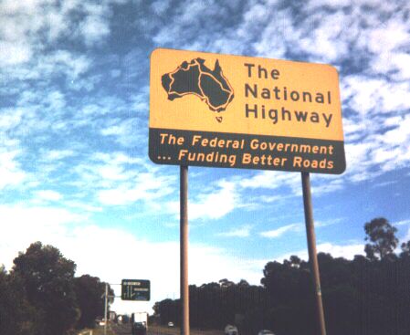
Starting off in Casula, I took a quick trip down to the local K-Mart to buy a disposable camera, then I took this picture at the southbound entrance to the M5 (South Western Motorway). This sign is placed at major junctions and at the beginning of many National Highways. Apart from being a bit of trumpet-blowing by the Federal Government telling everybody how good they are just for funding a few roads, they serve as a re-assurance that you are on a major highway connecting Australia's largest cities.
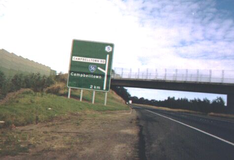
This picture shows a typical New South Wales exit sign. Most Sydney freeways use this type; Victoria tends to use the American-style overhead gantries which tell you which lane you're supposed to be in to get to a particular destination. Both styles have their advantages. The '5' in the hexagon means Metroad 5 (the route from central Sydney to the south-western suburbs), the '56' is a State Route marker, and is used in all but two states.
Route marking in New South Wales tends to be absolutely atrocious - route markers are mainly confined to directional signs at major intersections - but the few reassurance markers and trailblazers that exist are absolutely enormous compared to American markers. On high speed roads, they can be seen from hundreds of metres away, and the arrow is probably the height of an average eight-year-old kid. Metroads are quite well signed, but State Route marking usually leave a LOT to be desired.
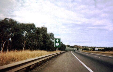
As noted elsewhere on my website, Metroads are simply markers used on the most major arterial routes in metropolitan areas designed to get people in to and out of the city centre (radial Metroads), and also to bypass the city centre (circumferential Metroads). Most of the radial Metroads meet up with National Highways or National Routes on the suburban outskirts, and this is what happens here just south of Campbelltown, about 55km / 35 miles SW of Sydney. National Highway 31 connects Sydney and Melbourne. About 80% of it is now four-lane dual carriageway with partially-controlled access.
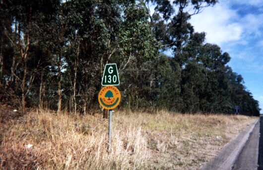
This is what Australian mileposts (or should that be kilometreposts?) look like. They're usually found on all state and national rural highways and occur every 5km (3 miles) and use the next major town (usually the control city) as their reference. This particular post shows that the distance to Goulburn is 130km. Beneath the distance plate is a marker for the Remembrance Driveway, inaugurated in 1954 by Queen Elizabeth II to commemorate the fallen soldiers in World War II. For every serviceman who gave his life, a tree was planted along the route, starting in Macquarie Place, Sydney and stretching all the way to Canberra. This route followed the original Hume Highway (now called Old Hume Highway, or State Route 89) but these signs popped up along the more recently built freeway in about May. I have no idea why the Remembrance Driveway was rerouted.
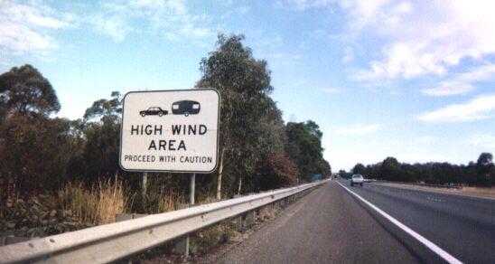
Okay, who ate those three cans of baked beans? :-) Sorry, couldn't resist... this one is about 75km / 45 miles from Sydney, and is posted before each of the numerous very high bridges in this area. At this point, you're high up on the plateau which completely encircles Sydney, and the river valleys are very deep, so bridges are high, cold and windy.
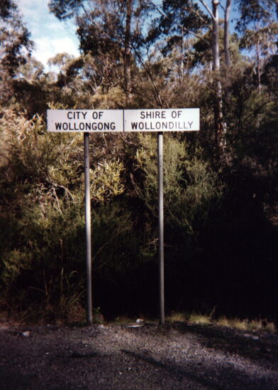
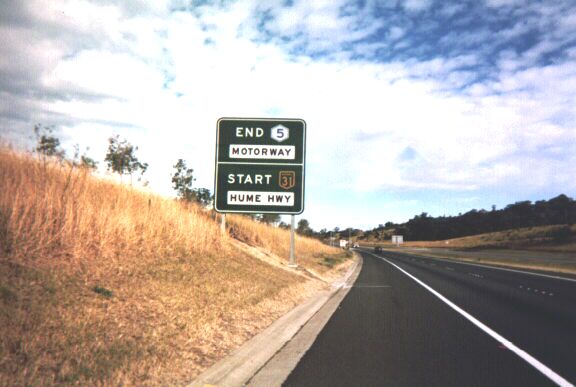
Just after that sign, I left the Hume Highway / NH-31 and joined Picton Road eastbound (SR-88). There has been discussion lately on the misc.transport.road newsgroup about how local government boundaries are marked on roads, and this is how most states in Australia do it. These signs are placed parallel to the direction of travel, which makes it often impossible to see when travelling by at 100km/h, so my guess is that these signs are mainly for the use of maintenance crews as reference points.
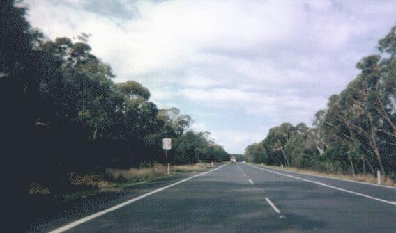
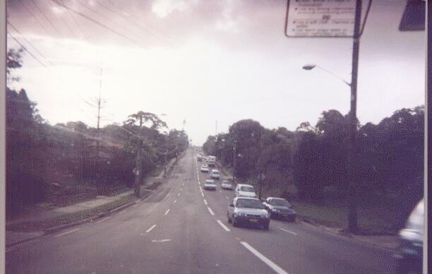
A typical stretch of Picton Road (SR-88). It's a good quality two-lane undivided road with quite a few overtaking lanes, and just as well because this road has a very large amount of truck traffic. This road serves as a vital link between the heavy industry of Wollongong - the home of the largest steelworks in Australia - and the many coal mines in the Picton region. So hooray for the overtaking lanes (anyone who has ever spent 40 minutes behind a fully laden coal truck on a mountain road with no overtaking lanes can appreciate my sentiment).
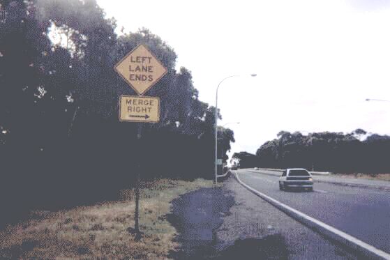
SR-88 ended at National Route 1 (better known as the Mount Ousley Road or the F6). I took a left onto this twisty and demanding four-lane expressway, and stopped at the huge interchange of SR-60, SR-69 and NR-1 to take a picture of this "Left Lane Ends - Merge Right" sign. I've always disliked this sign as it seems a trifle wordy. Surely a European-style sign showing a lane merging into the right lane would be much more sufficient, both visually over a longer distance and also for people whose grasp of English isn't that great.
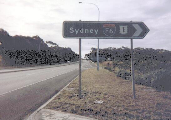
Oh I love this sign! Also at the same intersection you can see these signs on the NB onramps of SR-69. In the 1970's, when the many major freeways in New South Wales were built, the Deparment of Main Roads decided to give the freeways 'F' numbers, both for route marking and inventory use. National Highway 31, which I travelled on earlier, was known as the F5; the Sydney-Newcastle freeway was the F3 and so on. They were given these route markers which were a clear derivation of the American Interstate marker, except that the top bar had 'FREEWAY' written in them instead of 'INTERSTATE'. The top bar is also orange with black text, instead of red with white text, as is the case with US Interstate markers. Over the past few years, the F numbers have been decommissioned and just left with their National Route numbers, though F numbers have been retained for inventory purposes. But no-one ever told this sign here! Judging from the deteriorating quality and the shade of green used in this sign, I would guess that this is an original sign from the days of the freeway's opening in the mid-1970's. NOTE: As of mid-2001, this sign had been replaced by one without the F6 marker.
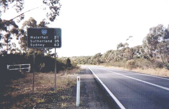
I then proceeded northbound on SR-60, or the Princes Highway. This used to be the main road from Sydney to Wollongong - the largest and ninth-largest metropolitan areas in Australia respectively. Can you believe it! I can't. This is a typical distance sign on a State Route anyway.
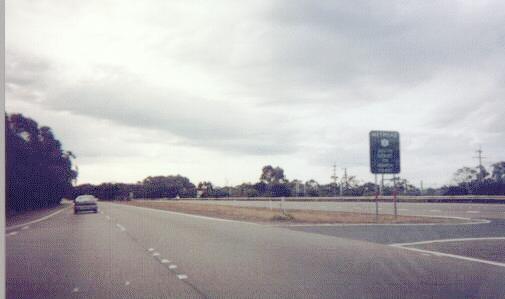
At Waterfall, SR-60 merges back with NR-1, and becomes Metroad 1. Metroad 1 is the part of the famous National Route 1 which almost completely circumnavigates Australia. Its quality varies from eight-lane urban freeways to dusty desert tracks remote from human settlement. This sign here says "Metroad 1 - South Coast to North Coast".
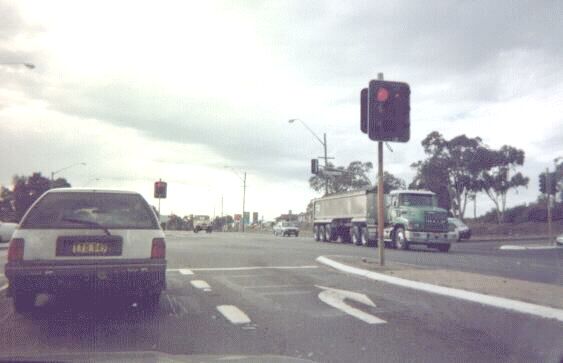
The uninterrupted run at high speeds soon ends at Heathcote, and soon enough you'll run into a traffic light. This traffic light in Engadine is what typical NSW traffic lights look like. Signal setups in Australia are, in my opinion, much better than those in America - the signals are much larger, they have dark backgrounds for better visibility, aren't so high off the ground that you have to crane your neck, and there are signals both on the near side and the far side of the intersection.
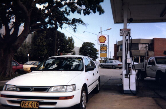
Soon enough, I stopped for petrol. I visited the Tramway Museum in Loftus, but it was closed (sorry, couldn't get close enough to take any pictures). While driving through the back streets of Sutherland trying to find my way back out onto the Princes Highway / Metroad 1, I found this Shell petrol station - unleaded was only for 64.7 cents per litre! (And no, that's not my car!) Which was just as well, because back out on the highway.....
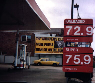
....what the hell???? 8.2 cents extra per litre? No, you have to be joking! And no, these two photos were taken on the same day in the same city in suburbs quite close to each other, separated by about five kilometres. Oh, and super (leaded) is 3 cents more expensive here... I should report the proprietor of this service station, because the Federal Government only charges a 2.2 cents a litre surcharge on super! Profiteering! Discrimination against those who are poor and can't afford a newer car which drinks unleaded!
We cross the Georges River heading northbound on the wonderfully ornate Tom Ugly's Bridge (couldn't get a picture, sorry, no shoulder and the traffic was too fast), and soon afterwards Metroad 3 splits off to the left while Metroad 1 splits off to the right. Metroad 3 is the main north-south bypass around Sydney, and often becomes wonderfully choked. The reason for this is simple, as we are about to see.
This is why it gets choked. This road is simply inadequate to handle the bypass traffic of a metropolitan area of nearly 4 million people. Okay, so it isn't four-lane undivided with houses and shops fronting it the entire length, but it's bad enough. Los Angeles has Interstate 405, London has the M25, Sydney has.... Metroad 3. Blah.
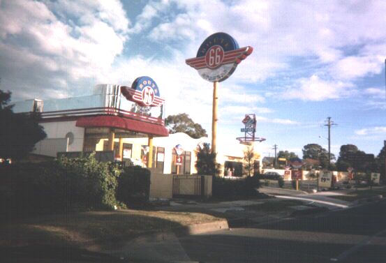
Having become so thoroughly disgusted with Metroad 3, I decided to go home and turned left onto Canterbury Road (SR-54). At Revesby I came across a Route 66 Burgers restaurant. Route 66 is a small chain of hamburger stores across the western suburbs of Sydney, and are often decorated with assorted roadfan paraphernalia, such as (fake) US route markers, and (real) American licence plates. They play suitably trashy 1950's music too over tinny loudspeakers, have checkered tiles on the floor and the girls behind the counter wear very mid-century dresses. Pity that the burgers don't cost 39 cents though like in the 1950's.
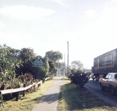
Ahhh! I cross the Georges River again, and I'm back in the City of Liverpool. This sign says "Welcome to the City of Liverpool - Proud Of Our Past, Confident In Our Future". Please, hand me the bucket. To the right of this sign, barely visible, is a standard placename sign installed there by the Roads and Traffic Authority notifying motorists that they are now in the suburb of Moorebank.
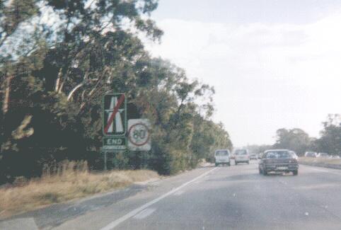
I turn left onto Heathcote Road and then get back onto the M5 motorway. Now I'm about to show you something which gets by blood boiling. A traffic light on a freeway. Grrrr, how dare they call it a freeway with a traffic light on it! Anyway, approaching it, you see a very ominous "END MOTORWAY" sign, and a partially concealed 80km/h speed limit sign. then about 200 metres down the way....
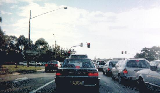
...yup! You find yourself backed up at a traffic light which seems to have an unending passion for the colour red. This traffic light is at the intersection of the M5 and Moorebank Road. Given the voluminous amount of traffic that passes through this intersection, you'd think that by now they'd have put a grade-separated interchange here, wouldn't you? But no. I am unaware of any plans to remove this disgrace from what would otherwise be the longest uninterrupted stretch of express road in the State. NOTE: A grade-separated interchange was completed at this location in December 2002, giving traffic an uninterrupted run without any traffic lights from Gore Hill on Sydney's North Shore to Holbrook NSW, a town about 500km south-west of Sydney.
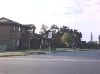
I find myself with a few exposures left on my disposable camera, so I decide to take a few snaps of my local neighbourhood, Casula. A month ago, Liverpool Council decided to implement a new 50km/h speed limit on suburban residential roads in the hope that it might save a life every now and then. As for my opinion? I'm all for it. Unlike many other councils which now have a 50km/h speed limit, Liverpool has only put the limit on strictly local roads with very low traffic volumes and where children are more likely to run onto the road. Areas which are now 50km/h are very clearly signed with "50 AREA" signs such as this one at the southern end of Tallowood Avenue, entering the street from Kurrajong Road.
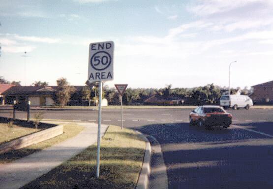
You are also told when you are quite free to do 60km/h again with this "END 50 AREA" sign. The circle is black instead of red, which is the standard colour on speed limit signs. In the background is a "Give Way" sign, which is the Australian equivalent of an American "Yield" sign. This photograph is taken from Old Kurrajong Road looking west to Kurrajong Road.
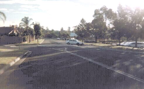
Now this is a roundabout on a local street. I actually like roundabouts, though I suspect most people don't share my opinion. They are much more democratic than Stop or Give Way signs, as all roads leading into the roundabout are treated equally. The rule in New South Wales regarding roundabouts is very simple - give way to all traffic already in the roundabout. However, unofficial conventions have arisen, especially for these very small roundabouts in residential neighbourhoods. Basically, you give way to anything coming from the right which is crossing your path. And you have the right of way over cars waiting on the road leading into the roundabout from your left. But these are just conventions, not officially recognised by the Police, so always exercise caution. This roundabout is at the intersection of Ingham Drive and Arwon Avenue looking west.
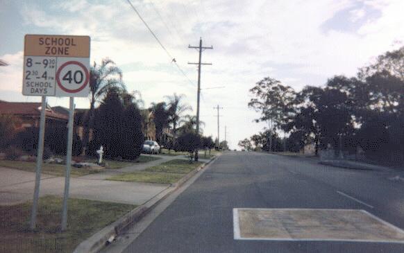
Now for the last picture - a School Zone Speed Limit sign. Nothing too special about the sign, but I like the way the speed limit is painted on the road. Normally, speed limits are painted in big white numerals. With School Zones, the speed limit is painted within a large yellow field, with '40' written out using horizontal yellow stripes. Quite effective in the sense that if you happen to miss the sign, you can't miss a huge slab of yellow paint in front of you. This is on Myall Road approaching Casula High School from the east.
Anyway, that marks the end of my road trip. I hope that I have been instructive as well as entertaining. If you have any comments or questions, simply e-mail me.