THE SEARCH AND DISCOVERY OF AZTLAN,
COLHUACAN AND CHICOMOZTOC
Thanks to the ethno-historic sources (Chimalpahin, etc.), we know that in the year 1064, eight Aztec tribes migrated from Aztlán (the land of herons), to the nearby Colhuacan (residence of the ancestors or residence of the hill bent forward) and, farther away, to Chicomoztoc (Seven Caves or Seven Canyons). One by one, they reached the Valley of Mexico... In 1325, after more than 260 years, the Azteca Mexica founded Mexico-Tenochtitlán (now Mexico City) in the Valley of Mexico. This was the very beginning of the so-called Aztec or Mexica culture.
When the Spanish Conquistadores entered the city in 1519, the Aztec had built a great and vast 'empire', extending from El Tajin to the borders of Guatemala. This 'empire' collapsed completely in 1521. A new 'culture' and a new faith were forced upon the natives and ancient knowledge was swept from the Indian minds. Many questions on the Mexican people remain. The most important of all questions is : "Where did the Aztecs come from, or where lay this mystic Aztlán, the origin of all Aztec tribes?".
Up to now, almost all Mexicanists believe that AZTLAN, the origin and homeland of the Aztecs (Mexicans), was only a mythological invention and that the town or region had never existed. Is this really correct? Why are there pictures of Aztlán and the migration of Aztec groups in the pictorial manuscripts? Are they all fake or imagination? No ! The Mexicans themselves believed in the existence of AZTLAN as we can see and read, not only in the pictorial manuscripts, but also in several ethno-historic sources.
It is a fact that Itzcóatl (4th Aztec king : 1428-1440), had destroyed all the historical manuscripts because "it was better that people do not know the truth about their past...". But, Motecuhzoma I (5th king or 'emperor': 1441-1469), after his many successful wars, felt the need to know more about his family history. He was obliged to organize an expedition with 60 magicians to search the homeland of his ancestors. They succeeded very well. They found not only Colhuacan, but also a 'hill of eternal youth'! In Chapter 27 of Durán (1967 II:215-224) we can read a remarkable account of Motecuhzoma's expedition with many details (Vollemaere 1993c). However it is most regrettable that the exact location of Aztlán, Colhuacan, and Chicomoztoc is not given in Durán's description.
We believe, like Motecuhzoma I, that Aztlán was not a mythical but a real region, a kind of province. So, we made a 'paper expedition' in the libraries. For the study of the migration from Aztlán to the Valley of Mexico, we studied the most important Mexican ethno-historic and colonial sources from the 16-18th centuries. We found the most interesting facts and information in following pictorial manuscripts:
After 3 years of study and investigations, we located in May 1991 (Vollemaere 1991d 'De mythe van Aztlán...' in Flemish) the three mythical places:
We reconstructed also the migration path from Aztlán to México-Tenochtitlán. Why and how did we come to these conclusions? We started with the first and most important problem, that was for us to locate roughly the region of Aztlán, Colhuacan and Chicomoztoc.
We read in Tezozomoc (1949:15 & 25), in Códice Ramirez (1985:17), and in Clavijero (1971:65), we know that Aztlán was situated: north or northwest of (ancient) Nuevo Mexico, east of the Colorodo River, above 35º north, and north of the Gila River. On colonial maps we find Nuevo México, a territory which in the 16th and 17th century extended to the north of Mexico higher than 35º north, in the southwestern USA. In fact, the actual State of New Mexico is only a small part of ancient Nuevo México. What is so special for this region? The desert and the canyons with the cliff dwellings !
Aztlán, or better Aztatlán, means 'between, in the middle of, or by (-tlán) the herons (aztatl)'. We can not do much with this description, because herons live seasonally along rivers all over the USA and Mexico. It is thus extremely difficult to locate mythical Aztlán right away, only by means of all the information mentionned earlier, but we can find certainly Colhuacan with complementary information. In the southwestern USA we know very well where the Colorado and Gila River run, but can we now find Aztlán? Not yet. We need to make first a detour by Colhuacan.
In 1991, we were able to make a breakthrough and solve the problem of the exact location of Colhuacan, which lead us eventually to the location of the peninsula AZTLAN.
Despite the fact that most of the sources we used are late, but very reliable, it is really strange that almost all the Mexicanists seem to have neglected the prevously mentioned ethno-historic information, and that they have never paid any attention to a possible presence of the Azteca Mexica in and around the northern and northwestern region of Nuevo México, and the land between the Colorado and Gila Rivers in the USA. We asked ourselves, what is so special about the region north of the Gila River and east of the Colorado River?
The answer is, there we find the habtitation of the Anasazi, the Pueblo cliff dwellers, who disappeared in the 11th-13th century, according to the Americanists. But a people do not disappear in the air just like that, you need to find them back elsewhere. How can we explain this enigma? Looking for an answer, we suddenly discovered the explanation by looking carefully and reading exactly the Aztec topoglyphs and ethnoglyphs. What do we know about mythical Colhuacan? Let us start with our interpretation of the topoglyph of Colhuacan. The word Colhuacan has at least two possible meanings:
- 'residence (huacan) of the ancestors (colhua)', and
-
'residence of the hill bending forward or under a bending'.
The topoglyph, representing the placename, shows in fact the wellknown classic Mexican picture of a hill, but this time with the top bending forward. We find one of the many examples in Codex Boturini 01. Every Mexicanist took the first explanation as interpretation for the topoglyph. We found that in fact both explanations are equally valuable for reading the glyph. Why? As we do when representing three-dimensional objects (a house, a car, a table), the ancient Aztec scribes applied drawning conventions. An example: to show the content of a box, the Aztec draw a cut of the box, showing the content. Examining the topoglyph Colhuacan, we came to the conclusion that the glyph represents in fact the cut of a cliff dwelling, this is a residence build under a hill bent forward. All the cliff dwellings of the States of Utah, Arizona, Colorado, and New Mexico match perfectly the description of a hill bent forward! The cliff dwellers lived in an alcove, in and under a hill bent forward, as simple as that.
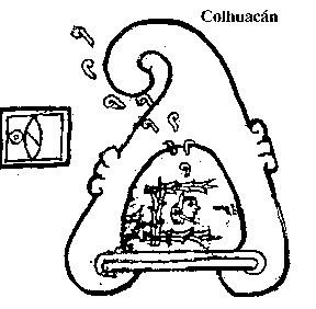
Mexicanists need to accept the fact that the topoglyph of Colhuacan represents a cliff dwelling, houses build in a great cavity of a hill bending forward. That idea gave us the possibility to find the three most important mythical places : Aztlán, Colhuacan, and Chicomoztoc. We can only find 'residences in hills bending forward', cliff dwellings, in Utah, New Mexico, Colorado and Arizona, NOT in Mexico ! Here we must look for Colhuacan... The 'cliff dwellings' are constructions build in great caves, called alcoves. Every cliff dwelling is in fact a Colhuacan. So, one of the thousands cliff dwellings must be the historic Colhuacan, but the question was which one? Without more information, it was impossible to find an answer.... In 1991 we urgently needed a clue, and luckily we found one by studying the history of the interesting 1st Aztec emperor, Motecuhzoma I.
Diego de Durán gives in his Chapter 27 (1967 II 215-224) a very interesting report of the huge expedition with 60 magicians, ordered by emperor Motecuhzoma I (1441-1469) in the 15th century. That expedition found the ancestors of the Azteca Mexica. As we understand it, they did not found Aztlán, but Colhuacán. This report gives many details, but failed to give us the right location of the site! Looking for a useful clue, we find thrice the mention that there was quicksand at the foot of the hill Colhuacan:
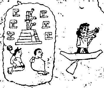
... Later they returned with their canoes, and getting all into them they eventually reached the hill of Colhuacán, of which they say that up to the middle there is very fine sand that is impossible to climb, because it is like a sponge and it is deep.....
... They presently started up the hillside after the old man. He started to climb the hill with great ease and without difficulty. They went after him, wading through the sand, with great difficulty and toil. The old man, turning his head, saw that the sand reached almost to their knees and that they were unable to climb...
... They, wanting to follow, remained on the spot and sank in the sand up to their waist...
But, how many of the thousands of cliff dwellings have quicksand? Maybe 1, 20, 100, more...? We were very lucky. We found out that there is only one cliff dwelling with quicksand: namely in Canyon de Chelly (East-Arizona), on the way to the White House cliff dwelling! This must be without hesitation the historic Colhuacán of the Azteca Mexica !!!
We have another very important second confirmation: at the foot of the cliff dwelling there are also houses, which are mentioned in the report of Motecuhzoma's expedition (the house of the old man). By the way, the report of Motecuhzoma's expedition also speaks of the existence in Colhuacan of a 'hill of youth', where people never grow old. We know the location!
Finding the location of mythical Colhuacán was for us not only a thrilling achievement, but it openened at the same time the direct possibility to find eventually the location of mythical Aztlán. Once Colhuacan was located, we searched for the possible location of Aztlán. We know that Colhuacán lay at some distance from the island, or land surrounded by water, of Aztlán, but was reachable by canoe (see Codex Boturini 01). We had to look for a waterway. In Canyon de Chelly (= Colhuacán region) we have the Chinle Wash, now a small seasonal water leading due north, right to the San Juan River. This river runs eastward to the Mesa Verde Anasazi, but westward to Lake Powell (Colorado River, Utah) and the Kayenta-Anasazi. At the confluence of both sinuous rivers, we have a large peninsula, surrounded by a waterline of about 150 km, practically like an island : Wilson Mesa-Grey Mesa.
This must be the old island of AZTLAN ! It is the only acceptable possibility in the southwest of the USA. In fact, it is a big peninsula in our eyes (150 km border !), and in the eyes of the Indians it is a land surrounded almost everywhere by water, just like an island. A trip around Wilson Mesa, as we did in 1993 in a houseboat, shall certainly convince everybody without hesitation. We have searched for, and we found there, much ethno-historic and archaeological evidence. We can explain now every obscure sentence in the maunuscripts.
From Colhuacan, the Azteca-Mexica migrated to Chicomoztoc, the Seven Caves or Seven Canyons, where they stayed for nine years. But where can we find Chicomoztoc? We found that the Gila Cliff Dwellings have Seven caves. This was certainly one of the several Chicomoztocs, visited by one or more Aztec groups on their way south. We need here to say that there were in fact many connections between the southwest of the USA and the Aztecs :
In 1991 we were also able to trace the complete migration path from Aztlán to México-Tenochtitlán !
To verify our hypothesis, we prepared a first preliminary exploration to the southwest of the United States of America in April-May 1992. The first part of the exploration consisted in a 2,200 km long exploratory flight over the Indian territories and over the famous Meteor and Sunset Craters. The latter had most certainly played a major role in forcing the Aztec tribes to migrate, since this volcano erupted violently in 1064, causing at the same time terrifying earthquakes. Around 30 cone craters were born over a period of four years during which they continuously erupted, and continued to do so for at least another 200 years. At the time, it must have been a fantastic spectacle for the Colorado and San Juan River peoples, with a skyline full of red firelight and menacing black smoke, an impressive end of the world catastrophe show. This must be one of the most important reasons why local Pre-Columbian Indians left the whole region.
While flying over, filming and photographing the peninsula along the San Juan River, we discovered ledges and large cavities (alcoves), suitable for cliff dwellings, suggesting the possibility of ancient habitation. Later research showed that in 1958, the University of Utah and the University of Northern Arizona made an inventory of 84 ruins alongside the San Juan River. The potsherds that were found indicated the site was inhabited from 900 to 1250 AD (the migration period). For all the details see Vollemaere 1993c. The peninsula of Wilson Mesa-Grey Mesa fully matches all ethno-historic data we have on Aztlán, thus confirming our hypothesis.
After landing in Silver City, we visited the seven caves of Gila Cliff Dwelling, about 100 km up north. We can almost certainly claim that this must have been one of the several historic Chicomoztocs. After our journey through the skies of the Southwest, we started on a land expedition of 3,300 km through the Indian territories of Arizona and Utah, during which we gathered lots of additional information and data. As said before, we located in 1991 the three major areas of the Azteca-Mexica migration, and Mexico has been given its 'roots' back ! We reconstructed also the complete, 262 year-long, migration path of the Azteca Mexica group. (See our publications).
The results of our 1992 Aztlán-expedition were very encouraging, because our hypothesis of the location of Aztlán (Wilson & Grey Mesa, Utah), Colhuacán (Canyon de Chelly, Arizona) and Chicomoztoc (Gila Cliff Dwellings, New Mexico) was fully confirmed. However, we had already managed to visit the latter two, but not yet the center of the province of Aztlán, i.e. Wilson Mesa and Grey Mesa, just in front of the Great Bend of the San Juan River. In 1992 we had passed over the mesas several times in our small plane, and had spotted caves and several alcoves (especially in Alcove Canyon) that could have been an ideal settlement in ancient times. We had also managed to reach Hall's Crossing (Lake Powell, Colorado River) by car, but it is still some 20 km away from Wilson and Grey Mesa, a table (mesa) mountain that can only be visited with a 4-wheel drive vehicle. Since we did not have such a car at our disposal, the only possible way to reach the site was by (house)boat, but unfortunately there was no time nor money available.
Early preparations started already in May 1992. This journey was to lead us to the junction of the San Juan River, the Colorado River, and Lake Powell (Colorado River). The main purpose of our April 1993 trip was to explore Wilson Mesa (Aztlán), to visit as many canyons as possible, and to make as many photographs and video recordings as we could. We hired a houseboat at the Wahweap Marina near Page and navigated on the Colorado River to Lake Powell, and then on the San Juan River to the Great Bend. Considering our very tight budget (our eternal problem: time and money), we are happy to say that we reached our goal with a maximum of success. We were able to visit one canyon at length and three others briefly.
We returned with many pictures and video recordings. We found some lithic material. Some sources (e.g. Kelsey) state that ruins have tumbled down, sweeping away all evidence of Pre-Columbian life, which now probably lies at the base of these alcoves and caves. Researching this rubble will be the task for archaeologists who have the time and the money to perform this kind of operation. We nourish the hope that one of the many American or Mexican Universities, with much larger financial means and archaeological research possibilities, will be interested enough to focus their research on Aztlán, in order to perform excavations in the canyons of Wilson Mesa, especially in the Grey Mesa part, the heart of what we believe to be Aztlán. We are convinced that many artifacts will be recovered, and that a new chapter of America's Pre-Columbian history will be written. In our desire to make this happen, we have decided to put all our material at the disposal of any university that would develop an archaeological program around Aztlán.
Beside that, there is good news. Thanks to our friend and sponsor, Roger De Brouwer (Belsele, Belgium), we were able, by the end of August 1997 to carry out a new exploration with a helicopter over the Lake Powell-Aztlán region. We detected east of the Nokai Dome "Anasazi" ruins, proving that the area was inhabited in ancient times, and showing that our hypothesis is solid.
Allready in 1991, we found thus, after many years of study, the locations of mythical Aztlán, Colhuacán, and Chicomoztoc. We were also able to trace the complete migration path. All our explanations and observations were published in detail, in Dutch and also in English, in our publication "Aztlán-Mexico" (Vollemaere 1991d & 1993c). The present website text and brochure (ask for information) is in fact a temporary annex for these volumes.
We decided to visit Utah by helicopter in August-September 1997 for a last check on the region of Lake Powell (Wilson & Grey Mesa = Aztlán), in order to conclude our final investigations on Aztlán. To make really a useful research in the Colorado and San Juan Rivers region, was to use a helicopter, but we knew also that the renting was very expensive. Eventually, thanks to Roger De Brouwer, a friend we known for many years, proposed to sponsor the helicopter and to rent a car.
Wednesday, August 26th, 1997, we flew with a helicopter from Ruby's Inn (near Bryce Canyon), to Lake Powell. After a wonderful passage of Rainbow Bridge, we headed for the Great Bend of the San Juan River. Our intention was to follow the San Juan River straight to Alcove Canyon in front of the Great Bend which is a so-called gooseneck. Alcove Canyon is the first important canyon of a group of seven. By a misunderstanding, the pilot made a shortcut, and he flew under the Great Bend instead of following the San Juan River, so that we came to the entrance of the smaller, eastern part of the San Juan River, far away from Alcove Canyon. So we lost certainly at least 3/4 hour. But maybe this was destiny, since we were very lucky. Indeed, passing along Mikes Mesa, and exploring the region east of Nokai Dome, I detected suddenly (very exited of course!) a relatively large ruin halfway up in the western vertical cliff of what I assume must be the canyon of Castle Creek. Orientation was a real problem in that rough region due to the fast and multiple turns of the helicopter!
The estimated dimensions of the alcove are 13 m long, 3 m high, with a depth of 8 m. In the right corner there are ruins (habitation) in very bad shape, made in a white, grayish stone (a granary?). On the left side there is a complex of several reddish rooms in relatively good shape. The ruins are probably easily accessible by a soft slope of stone debris in the canyon. We do not know if anyone else has found these ruins in the past (maybe this is the Castle of Castle Creek?), and if these ruins are already properly investigated and inventorized. Please, inform us as soon as possible and send us data for further study. Thank you in advance. Awaiting your reactions, allow us in the meantime to name the site 'Volmarstein' (Stone house of Volmar), after the residence of our ancestors in West Germany. If these ruins are really unknown by the archaeologists, they should be investigated as soon as possible. However, it does not matter if the ruins are well-known or unknown. The most important fact for us is indeed that there are ruins in an area that we consider as being Aztlán. We assume that the site belongs to the Tepaneca (People of the stone houses), one of the eight tribes who left mythical Aztlán.
We are now searching for grants for a systematic helicopter survey of the Grey Mesa and the region east of Nokai Dome. We are open for a close cooperation with a university, and all our material is available for institutions and scientists. As soon as possible, we intend to publish a larger paper on the subject.
Most of the academic Americanists are not so much interested in rock art because they consider it as a matter of (very) low interest. In contrast, as paleographer, I am interested in all the different forms of writing systems, even early and primitive writings. As will be seen at the end of this paper, the study of the thousands of petroglyphs of Utah can bring us a much better understanding of ancient life and brings us the possible reconstruction of the history of the AZTLAN region.
Before the URARA meeting in Price, we had already a very good "electronic" contact (fax, E-mail) with Alex Patterson (Greenwich, USA), a good rock art writer, in regard of the interpretation of codex Boturini (Tira de Peregrinación). This pictorial manuscript presents an interesting picture of the start and the evolution of the 262- year migration to the south, to Central Mexico, of eight Aztec tribes. The personal contact at Price with Alex and his wife Mary, not to forget their friendly dog Henry, and Tom and Terry Hoff (Colorado) was very agreeable and instructive.
At the beautiful Prehistoric Museum of Price, we also met Cecilio Orozco, professor at the California State University of Fresno (California). Years ago, he came also to the general conclusion that Aztlán must be situated somewhere in the State of Utah, but without specifying an exact region. He told me that he based his conviction on the fact that the Spanish explorer, Francisco V squez de Coronado, searched in 1541 in that direction, in order to find the ancestral lands of the Azteca Mexica. He also followed the idea of his professor and friend, Alfonso Rivas Salmon of the Universidad Autónoma de Guadalajara in Mexico, who says correctly that the land is called Nahuiatl, nahui = 4, and atl = water, the land of the four waters. One of the waters is certainly the Colorado River. Furthermore, he says that Huehuetlapallan, "old, old, colorful land", was situated somewhere in Utah, Colorado, New Mexico, and Arizona. For our part, we consider more precisely the Red House Cliffs, beside the road from Blanding to Hall's Crossing, as Huehuetlapalan, the "very old red land". For the word Nahuatl, we can give a little bit more explanation. The Simeon Nahuatl dictionary says indeed:
It is a fact that Nahuatl, the Azteca Mexica language, belongs to the large Uto-Aztecan linguistic group. It seems very clear to us that in ancient times the Nahuatlaca group was focused around the Utah-Arizona border, this is the land of the "4 Waters". This group spread out to the south and occupied later a very large part of Mexico. This was for us indeed a first indication that (mythical) Aztlán must be sought in the area Utah-Colorado-New Mexico-Arizona, and not elsewhere, certainly not in present-day Mexico. But saying that Aztlán must be somewhere in Utah is scientifically not enough. As said before, for many reasons, we found in 1991, after three years of study, the precise location of mythical Aztlán, Colhuacán, and even of one Chicomoztoc. We published then the scientific proof and the first explanation of our arguments. Now in 1997, we eventually found the location of the eight Aztec tribes participating in the migration in 1064. It was a worthwile, amazing and fascinating, once in a lifetime, experience!
Aztlán, Colhuacan Chicomoztoc found, there was still left one big problem: where lived the 8 Nahatlaca tribes in the 11th century? As far as we know, nobody has yet answered that question.
In Codex Boturini 3, we see the name glyphs (ethnonyms) of the eight tribes who left Aztlán for a long migration to the south. Is it possible to find the original location of these groups by means of their name glyph? Yes, we thought so, because those glyphs render very well a typical or particular aspect of every tribe. We want to share our findings in that regard. But, be aware that this is our first approach for the problem of the location of the eight Aztlán tribes, and that we therefore present here in fact the framework of a first work hypothesis, that must be developed and improved. Constructive critics are as usual welcome. It is useful to give the meaning of following suffixes in Nahuatl (Aztec language):
The first Aztec tribe glyph of Codex Boturini 2, suitable for an interpretation, is certainly the one which represents the Huexotzinca, the people of the willows. This people must have lived in a place where the willows grew. Where do we find willows? Not on the mesa or on top of the hills, or mountains, but in general in the canyons and creeks near the small waterways, because it is a waterloving tree. Because we find willows in the canyons, we may say that the Huexotzinca must have lived in some or most of the canyons. But, the question is, in which canyon(s)? The first group of canyons that comes to our mind is logically the Alcove Canyon group of Wilson Mesa and Grey Mesa, just in front of the Great Bend of the San Juan River. From the canyons, the Huexotzinca could easily control the navigation on the San Juan River in both directions. They could, for example, have asked toll for a passage. This is the explanation for one Aztec group, but can we explain or interpret other tribe glyphs? Yes, we can indeed.
The second tribe glyph suitable for explanation is for us the most interesting one because we see the name glyph with the eyes of a deeply interested paleographer. After our Utah helicopter exploration of August-September 1997, we wrote our general field report. We remembered our most interesting talks with Alex Patterson, a very good rock art specialist. He told us of his good friendship with the Hopi Shaman Martin. The Shaman told him that the Hopi tribe once belonged to the Aztec group, but that they separated from the other groups migrating to the south. For one reason or another, they decided to stay in the north and left the other seven tribes. As a matter of fact, we know that Codex Boturini 3 pictures the separation of one group: the Colhua (Ancestors). The chiefs are represented with tears in their eyes. Is this Colhua group in fact the ancient Hopi (Moqui) tribe? ( We believe so, for many reasons; we find Hopi-signs in Canyon de Chelly, etc.). Both tribe names (Colhua and Hopi) mean "ancestor", like so many other Indian tribe names do (Anasazi, etc.).
Alex Patterson sent us an E-mail, announcing his intention to visit Moqui Canyon next year (1998). A ranger told him that there are petroglyphs, and that he found there the pre-Columbian body of a girl who had died from starvation. We know not only that there are at least three Anasazi ruins on the north side of Moqui Canyon, but also that Moqui, or Moki, is an archaic name for Hopi. If the canyon name was given by the Indians, and not by white men, then we could say that we have here the ancient home of the Hopi tribe, or in other words, the Colhua group. But we have to check the origin of the name-giving of the canyon, before jumping to conclusions. There is however a very interesting point to study: the name glyph.
As we see, the tribe glyph (ethnonym) represents water, running first over a square surface, and then finally falling down. This clearly indicates a waterfall, a cataract, or a rapid. Therefore we must call this Aztec tribe more correctly People of the Rapids. If they are called Colhua, it should be better to designate them by the name of Acolhua, or Water (Atl)Colhua, an Aztec tribe who came later to the region of Texcoco in the Valley of Mexico.
It is a fact that there are many small waterfalls during the rainy season in
the Lake Powell area, but more impressive and famous are the many cataracts or
rapids of the Colorado River in Cataract Canyon. Cataract Canyon starts just
below the confluence of the Green and Colorado Rivers. This canyon is famous for
the 25 rapids above the high water mark (HWM) at 1128 m. The first cataract is
situated just south of Spanish Bottom, which is in the heart of Canyonsland
National Park, and the last one is located just north of Imperial Canyon. But,
before the building of the Glenn Canyon Dam, there were in fact 62 rapids in
Cataract Canyon, as we can read in Dellenbaugh's Diary (Kelsey 1989:74) for
September 29, 1871:
..... A large canyon entered from the left (Sheep Canyon),
terminating Cataract Canyon, which we credited with 41 miles (66 kms), and in
which I counted 62 rapids and cataracts...
Therefore we may suppose that the Cuillahuaca (Acolhua / Hopi), lived in the region of the rapids from the confluence of the Green and Colorado rivers in the north to Moqui Canyon (north of Hall's Crossing) in the south. In that region there are found many Anasazi ruins, potsherds, and petroglyphs. The Mesa Verde and Kayenta potsherds belong to the period 1000-1300. In this period falls the first migration (1064) of the Aztec tribes to the south.
In the 1940's, a team of archaeologists from the Carnegie Museum of Pittsburgh explored the upper parts of Palmer Canyon from the rim. They found three different Anasazi ruins with many Mesa Verde style potsherds. One of them was dated between 1026 and 1127, and another was dated between 1070 to 1164. Easter Pasture Canyon is on the west side of the Colorado River, in front of Palmer Canyon. There are four springs near the extremity of the canyon, were are also 4 small Anasazi structures in very bad condition. One was a living quarter, and the other three were for storage use. All these facts support our Aztlán hypothesis.
The Nahuatl (Aztec language) name Malinalli means "a winding plant, liana, plaited plants", and the root Malina has the signification of "to plait something like hair, or to wind up a rope, etc.". A derived word is Malli, a prisoner, someone who is tied up. In the period before the building of the Glen Canyon Dam, this plant could be found along the rivers. With the fibers they made baskets. In fact they must be the first basketmakers of the region. We may even suggest that, certainly also using tollin (reed, cane, growing along the river) for plaiting mats petlatl, they were in fact also the first TOLTECA. Therefore, we place the Malinalca, or ancient Tolteca, along the Colorado and San Juan Rivers, on the west and south side of Wilson Mesa, and also along a section of the Escalante River. The 1956 explorers of the North Arizona University found there many Indian sites. This area is thus the original region of TOLLAN, which was an important part of AZTLAN. It is a fact that the same region was seasonally visited by the herons; therefore we may call this long ribbonlike river land, in the same time, also correctly AZTLAN...
The Nahuatl name tepantli means a stone wall or a separation. In fact, the Tepaneca built not only granaries, but also many houses in stone. Almost all the other Aztec tribes, moving along the waters or over the mesas and in the woods, made temporarely shelters with poles, leather sheets, plants, and earth (adobe). Only sedentary people like the Huexotzinca and the Tepaneca constructed small hard buildings. Therefore we locate the Tepaneca in the region of the Red House Cliffs where we find stone houses. We assume also that this region must be mythical Huehuetlapallan, the ancient Red Land of the Aztec people.
The Nahuatl name for fishnet is matlatl, and -tzin is a suffix indicating a reverence. The name glyph for the Matlatzinca is a fishnet on a stick. One can fish with such a fishnet near the riverside, but open water is a better fishing ground. To locate the Matlatzinca, we feel therefore the need to look for open waters, like a lake, where it is easy to find plenty of fish as we know by experience on the San Juan River. Because the water relief has changed due to the construction of the Glen Canyon Dam, and does not correspond with pre-Columbian times, we need maps made before 1960, the year when the dam was started. In the meantime we see three possibilities:
We choose the last one, the San Juan River region, corresponding better in the Aztlán context, than the other two.
The Chichimeca are graphically represented by a bow and an arrow, because they were primitive hunters, following game in the plains and the forests. We must translate Chichimeca indeed by Lineage of the Dogs, or Suckers, because chichi means dog; as verb it means "to suck (milk, etc.), or to sew". We do not know why they were called so. Maybe because they were able to follow easily traces of animals, just like dogs do. The Chichimeca hunters shot rabbits, deer, goats, etc., and therefore they lived partly in open space, and partly in the woods. As we can see, the majority of all the petroglyphs found in Utah concern game animals, like on Newspaper Rock near Road 211. These petroglyphs were surely made by local hunters, probably by the Chichimeca. That is the reason why we locate them, for the moment, in the region between Newspaper Rock and Natural Bridges National Monument; i.e. in the region of manti-LaSal National Forest, Abajo Mountains.
The location of the last two tribes was not so easy to find and to explain at first, but we are convinced that we have now found a very good explanation. Let us start with the Chalca.
In general, we see that Chalca is translated as People of Jadeite because chalchiuitl means in general precious green stone, especially jadeite (Thouvenot). We find a lot of small statues in jadeite or nephrite in the Olmec region of La Venta, and jadeite jewels (necklaces) in huge quantities in the Maya area, but not in Utah. The Chalca came from the north, from Utah. There we do not find much jadeite. So, if the Chalca were stone workers in origin, as we may fairly assume, then they must have originally worked on other kinds of precious stone. Therefore we must search their ancient home in, or not far from, a region rich in precious material. There is always a possibility to trade raw material with a distant group by barter
What do we find in Utah, and where? In some places in Utah one can find blue azurite, green malachite, copper, and coal (meaning that there were once forests in prehistoric Utah). Along the Green River, we find not only many petroglyphs and some ruins, but also beautiful petrified wood, jasper, silicified dinosaur bone fragments, and agate (Halka Chronic) suitable for the manufacture of jewels. Petrified logs are found also in the Escalante Petrified Forest and in other places in Utah, even in the Lake Powell region. Can one of them have been the region of the ancient Chalca? Are there other indications? Yes, there are.
Making jewels is one thing, and wearing them is another thing. Where do we find people wearing jewels in Utah? The most striking fact is that only the Fremont Anasazi people, who lived in the area south and southwest of the Green River, have beautiful clay figures showing clearly people wearing large, elaborate necklaces. It is therefore obvious that the so-called Fremont Anasazi must in fact be the ancient Chalca group. This is why we do not hesitate to place them, in the 11th century, south and southwest of the Green River, in the direction of the Escalante River.
For locating the last group, the Xochimilca, we must look for an area suitable for chinampas. Therefore we need relief maps drawn before 1960. Why? Because we have now in modern times a much higher water level caused by the building of the Glen Canyon Dam. We are expecting to receive these maps in the near future, but in the meantime we can give the following explanation. In Xochimilco, in the Valley of Mexico, we find a still existing and very good example of the ancient way of making flower and vegetable fields in marshes and swamps, by draining the wetlands. So, we have to look for wet and flat lands, marshes or swamps in the pre-Columbian Aztlán region. Were can we find such an area? We see for the moment three possible locations:
We are in favor of the last possibility. Therefore we place the ancient Xochimilca in the region of pre-Columbian Piute Farms on the southside of the San Juan River.
Locating and finding mythical Aztlán, the roots of the Azteca-Mexica and of
Mexico, is in a certain way comparable to the discovery of Troye by Schliemann.
But ATTENTION : nobody is perfect. We need to verify
every angle of our new findings and hypothesis, and will correct wherever it
should be necesary. With your help we can achieve it. We repeat that our work is
only a first and new approach to locate the eight Aztec tribes who left
'mythical' Aztlán in the year 1064. Nevertheless, we have the impression that
this paper is a very reasonable working hypothesis, and at the same time maybe a
good start for the reconstruction of the ancient history of Aztlán. We know that
there is still a lot of work to do, too much for one person. That is why we need
urgently the cooperation of everyone, of you, for further investigations in the
matter of rock art, artefacts, jewels, ruins, sites, etc. (location, pictures,
information, comments, dating, etc.) in Utah, Colorado, New Mexico, and
certainly also in Arizona. We need a lot of data for the reconstruction of the
past of this very important part of Utah, for the region where we have finally
found mythical Aztlán, the land of the ancient Aztecs, the area with the roots
of Mexico. We are especially looking for the location and information about the eight figures we give
in annex. That is the reason why we make now an urgent call for your appreciated
cooperation. Where have you seen these petroglyphs or vaseglyphs?
In 1991
we were very pleased and proud by the idea to have given the Mexicans their
roots back. Now in 1997, we are very happy to succeed in finding the original location of the
eight Nahuatlaca tribes who left the province of Aztlán in the year 1064,
and migrated to the south, to the Valley of Mexico. This makes our
investigations complete.
There is an AZTLAN-book in English (1993) and
Flemish (1992), and a brochure about the new findings of 1997 in English.
, please mailto [email protected] or
write to