To next page
Ahmad ibn Majid al-Najid (1462): Kitab al-Fawa'id fi usul al-bahr wa'l-qawa'id. (the book of profitable things concerning the first principles and rules of navigation) from Julfar (Oman)
------------------------------------
From f.1r to f.88r of the paris Ms 2292
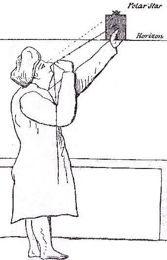
The Kamal an instrument to measure the height of the stars above the horizont. The knots in the rope give the amount of fingers (isba) above the horizon of the star. This measurement is used widely in all his books.
of the Portuguese
......for this is a science without which one cannot measure the Qibla of Islam accurately, and everything that I say and do will show just how accurate we can be. For how long a time have we sailed in ships from India and Syria, the coast of Africa (Zanj) and Persia, the Hijaz and the Yemen and other places, ...
The first man who organized such a thing and built a ship was Noah; on the advice of the Almighty through Gabriel. This ship was put together in the form of the five stars of Great Bear, and the stern of the ark is the third star of the Bear and the keel is the fourth, fifth and sixth stars, while its bow is the seventh star. Till now the people of Zanj, Komr, from Mrima (or Al-Rim)(the coast near Mombasa) and from the land of Sofala call the 5th and 6th star of the big bear al--kirab (or al-Hirab)"the keel of the ship" - these are two stars used for determining latitudes at the culmination of al-Sarfa when the Faraqid are invisible - for from these two, the form of the keel of Noah's ship was taken.
Al-Nathra. This rises at dawn after the 247th day of the year and at its culmination, the Farqad is used (when it has equal altitude) with the Pole Star and is on the east of it. The bashi there is just under one isba. Al Qaid is then used with al-Dil for latitudes and the 7th of the Plough (al-Qaid) when rising with al-Aiyuq when setting and these are used on the equator and into the southern climates and under the wind as for example in Java and that neighborhood and in Madagascar and in Zanj.
The most auspicious of the auspicious ones (Sa'd al-Su'ud). It is a southern lunar mansion and in the constellation of the Goat according to all the early authorities but the people of Zanj at the date of this book regard it as part of Aquarius.
As for the tirfa al-rahawiyat, here we have more accuracy because of experience, general management, use and calculation on such routes as those from Munaibar to al-Atwah (Arab coast), from Gujerat to al-Zanj, or from Sadjam (Sadgaon) to the end of Siam, i.e. courses using a bearing from SW by W through S to SE by E or thereabouts.
After this comes the use of the sixth star of the Plough at 8 deg. P.S. with al-Sharatan setting at 8 deg P.S. A more generally useful (measurement) cannot possibly be found in the whole of the heavens......
I have pursued it for many years in the northern climates from 12 deg P.S. until the Pole Star disappears. It is used from the coast of Java to Zanj and China, in all the seas of the world....
In Jawa on the west coast is a harbor called Shunda, which is also a cape. At the same latitude in Zanj is Mombasa, and people do not disagree over this for it is well known.....
The Plough (G.B.) is 12 isba in the land of Zanj and Madagascar and we have mentioned it all in the Hawiya and everyone agrees with it...
Al-Munji (bird often described as a sign that land is close)is found on the coasts of Zanj and Somalia. Kuraik (another bird often described as a sign that land is close) is found nearer to the coast than Al-Munji and is not an accurate sign when the Pole Star is higher than 11 deg anywhere in the world. The sea snake can not be missed by anyone who travels from Mulaibar to Somalia (the sea snake was seen as the first sign one notices when land is close) . The truth is that from the coast of Madagascar a reef stretches out under water to somewhere between al-Fal and Soqotra and it contains hawass and tannur. (small sea creatures)
that held back Yunus (upon him to be peace) and the fish swallowed him while he was blameworthy. When you have passed this place you come to Asifi, a well known place in the Maghrib. You have now really reached the Maghribi coast. When you approach it you enter into the gate of Sabta. (Straits of Gibraltar)
Know, oh seeker, that every man knows his own coast best; the Chinese China; the people of Sofala; Sofala; the Indians , India; the people of Hijaz, the Hijaz; the Syrians, Syria...
"The next island after it in size is that of *al-Qumr*. This is an island at the present time. Opinions differ as to its longitude and latitude (?length and breadth) because it only borders on the inhabited regions of the world, and the occupied climates of the world, hence there is an element of doubt about it. They say in the Great Books that it is the largest inhabited island in the world and its longitude is approximately 20 degrees. Between it and the coasts and islands of Sofala are other islands and banks, but these do not prevent travelers from traveling among them. The island is called al-Qumr after Qamiran b. Amir b. Sam b. Nuh and to its south is the sea known to the Greeks as Uqiyanus which is known to the Arabs as the 'Ocean which encircles the world'. Here is the beginning of the southern Dark regions to the south of this island." [Note; Vagueness owing to 'recent discovery' and fewer visits than to African regions.]
When your spring sojourn in Awail has ended
and the winter draws near, then evil becomes the sojourn.
Also the beginning of the Saba wind and the end of the Damani wind, is the correct season if you wish to cross from the Atwah coast or from Hormuz, but from the Yemen it is not possible at the beginning of the Saba and the end of al-Dabur. This is also the season for most ships crossing from Madagascar to Zanj and al-Rim and Hormuz and India and from Jawa to Mallaca and Sumatra and all places below in the southern climates up into the northern climates.
One should not come out from the Atwah coast to Yemen along the coastal route after the 80th day (10feb), and similarly to the land of al-Handiya (Somali tribe) from al-Atwah and from Gujerat and Mulaibar, for fear that he runs into the Kaws before he reaches his destination.
Traveling from India to al-Zanj should be done up to the 80th day of the year (10th feb), it being no good after that (this to arrive in Zanzibar before the beginning of the SW monsoon in early March) and those who travel from Aden and Yemen to Zanj should start on the 320th or the 330 th day (8th , 18th oct). (this to round Cape Guardafui on the last of the westerly winds and then catch the NE monsoon in the Arabian sea.) From Sihr he should go 20 days later and from Zafar from the beginning of the Saba wind (this is the NE monsoon) to the 70th day (31st Jan)(later then this you will run into the SW monsoon close to Zanzibar) no harm
will befall him for he is riding on the Saba winds and the same rule applies to him as applies to someone coming from Hormuz.
From the East Indies to Africa and back
Know the occurrences of all the seasons and winds. (The season for sailing) from Manaqabuh and Fansur and the ocean side of Sumarta to the African coast begins on the 60th day of the year (21th jan) and is not good at any other time.(because at this date the NE monsoon reaches its furthest southern extension and will remain there till the monsoon change off Zanzibar in March) The same applies from Sunda bari and Lasem in Java. The journey from Madagascar to the African coast has two seasons, at the beginning of the Kaws which is a weak season and at the end of the Kaws which is also weak. But the people of all the southern climates, when they which to sail at the end of the Dabur winds have to put up with rains as far as the equator and this is sufficient (on these monsoons). Similarly with people from Sofala and the estuary region (Akhwar) to the Zanj coast and from the land of Timor to Jawa and the neighboring places, from Maluku, al-Ghur and Jawa and all the Islands of the south : they only travel at the end of the Damani wind, every man in accordance with the suitability of his place and his boat. (this is from mid-November to the first of April during the NE monsoon).
Know that approaches to al-Hadd begin on the 140th day of the year (11th April), and the same at Guardafui. They begin on the 150th day, at Hafuni and at Masira on the 160th (1st May) ........
Approaching Soqotra at or before the 100th day (2nd March) is better than approaching Guardafui or Samha or Darza which should be approached around the 120th day (22nd March)........
It does no good to get too near Soqotra except when necessary in the Kaws winds when coming from Hormuz or from Zanzibar to Zafar. The best time for approaching Soqotra and Qalhat is up to the 130th day and never later........(the problem with Soqotra is that during the SW monsoon a strong easterly current flows south of Soqotra and this must be avoided.)
Seasons from the north to al-Zanj
The beginning of the travel season from Rim coast and the land of Moqadishu to Zanj and Madagascar is before the New Year by a few days until (the end of) the Tirma when one should fear the Kaws winds, for there are always breezes of the Kaws winds at the time of the Tirma on the Zanj route. How many times has a man coming from India at the end of the Indian season found the Kaws winds causing him to return and put into Aden: and he will never touch Zanj.(the NE monsoon is so weak by the time it reaches Zanzibar that ships fail to reach it). He who travels from Gujerat in the 90th day (20 feb) takes a great risk. Know these seasons and these rules.
(Every late traveler enters Shatijam
When he comes from India and the Maldives, so be silent)
The people of Madagascar come out towards Zanj and those
Who desire Hormuz from Zanj or Aden.
The resolute man would not aim for Bahrain
Except its own people, for diving has ceased at this time.
Similarly from Shatt al-Furat and its land
Some find it possible out of necessity if they have cargoes.
If a star appears at the beginning of al-Durura,
Set out from al-Ahqaf to al-Zanj with sure knowledge.
Had a man set out from Zafar later than this.
It would not matter either in al-Al'la or any place.