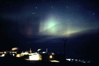
 An Aurora over
Mactown. I found this photo in Eric's computer but don't know who
took it. It may have been taken during the winter of 1997.
An Aurora over
Mactown. I found this photo in Eric's computer but don't know who
took it. It may have been taken during the winter of 1997. Scenery and Other Pictures.
An Aurora over
Mactown. I found this photo in Eric's computer but don't know who
took it. It may have been taken during the winter of 1997.
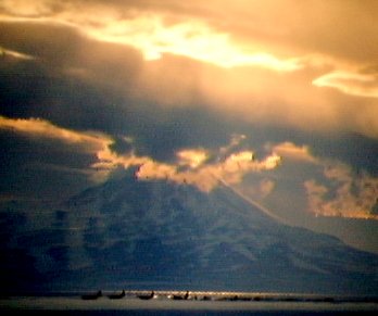
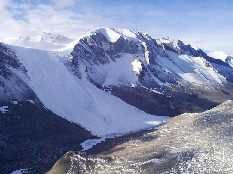
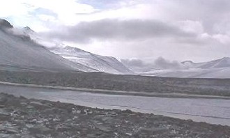
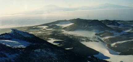
This was taken looking from Ross Island towards Mt. Discovery,
which is about 80 km away. The ice runway you see in front is
only about 5 km away. The C130 Hercs are kept busy flying from
here to the South Pole and back again. In the summer of 1998 they
were expected to make about 350 South Pole flights to allow the
continuation of the South Pole rebuilding. It is Erics Photo which he had on slide.. Using a very low tech method of projecting it onto a wall and then taking a digital picture of it I was able to get some of his excellent photos, which are sprinkled though the whole web site.
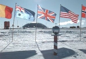 A picture
library wouldn't be complete without the South Pole Station and
the legendary South Pole marker. You can see the South Pole
standard in the front, the different nationalities' flags and,
way in the background, the South Pole protective dome.
A picture
library wouldn't be complete without the South Pole Station and
the legendary South Pole marker. You can see the South Pole
standard in the front, the different nationalities' flags and,
way in the background, the South Pole protective dome.
 On top of the
hills behind McMurdo and Scott Base is an area called Arrival
Heights. The area is designated as a radio interference-free
site. The satellite dish, which telecom NZ installed borders right on the side of a SSSI zone. The Americans were not too happy about it, but
tests have proven beyond doubt that the radio interference from
the satellite dish is so minimal as to be nonexistent. The
Americans did however, and strangely enough, install a radio
transmission and receiving site directly overlooking the same
area.
On top of the
hills behind McMurdo and Scott Base is an area called Arrival
Heights. The area is designated as a radio interference-free
site. The satellite dish, which telecom NZ installed borders right on the side of a SSSI zone. The Americans were not too happy about it, but
tests have proven beyond doubt that the radio interference from
the satellite dish is so minimal as to be nonexistent. The
Americans did however, and strangely enough, install a radio
transmission and receiving site directly overlooking the same
area.
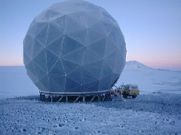
From the engineers keyboard......>>>
The 14 metre radome houses a 9 metre dish antenna tracking one of
INTELSAT's Pacific Ocean Satellites, which links it to Warkworth, north
of Auckland. The radome is made of panels of Kevlar stretched on
triangular aluminium frames bolted together to form a strong geodesic
dome. It's rated for 320 kph winds, and it has to be to survive Arrival
Heights. The panels are actually "Eggshell Green", despite their
distinctly blue appearance in the picture, which was taken looking east
towards Crater Hill - beware the 200m precipice down to McMurdo Sound
just behind you! Notice the radome is stood off the ground on piles so
the snow blows underneath instead of drifting against it, just like
Scott Base itself - a nice piece of Kiwi ingenuity. The location is
Arrival Heights because that's the nearest place to Scott Base where the
satellite is just visible over the western flank of Mt. Erebus. There's
only a degree or so of clearance, but since the satellite only moves a
fraction of a degree in the sky, there's no problem providing 24-hour
service - the first, and still the only, standard full-quality dial-up
public telephone service from Antarctica. Just pop your ordinary Telecom
phone card in the slot, and dial the world! To keep maintenance to a
minimum, most of the fancy electronics are back at Scott Base, and the
signals are fed across on a battle-field quality (i.e. Antarctic bulldozer-proof)
fibre optic cable. Power also comes from Scott Base, via an armoured and
screened cable alongside, so there are no smelly, high-maintenance
diesels up there, either.
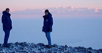 Looking west from
the Dome (beware the 200m drop into McMurdo sound), Eric and I pose in front of the Royal Society Ranges
which are on the other side of McMurdo Sound. This photo was
taken on the last day of official sunrise for 1998 summer season
and an hour before the last, brief glimpse of the big orange
thing in the sky. This particular day I decided it wasn't really
that cold at -18 deg C and only wore jeans. (My thermal gear was
still in the vehicle.) This was fine for a while until I stopped
moving. Silly me! I'm literally freezing my butt off and my
knees feel like they've rusted up. Straight after this
photo, I dived back into the vehicle and cranked the heater up to
thaw out a bit.
Looking west from
the Dome (beware the 200m drop into McMurdo sound), Eric and I pose in front of the Royal Society Ranges
which are on the other side of McMurdo Sound. This photo was
taken on the last day of official sunrise for 1998 summer season
and an hour before the last, brief glimpse of the big orange
thing in the sky. This particular day I decided it wasn't really
that cold at -18 deg C and only wore jeans. (My thermal gear was
still in the vehicle.) This was fine for a while until I stopped
moving. Silly me! I'm literally freezing my butt off and my
knees feel like they've rusted up. Straight after this
photo, I dived back into the vehicle and cranked the heater up to
thaw out a bit.
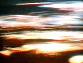
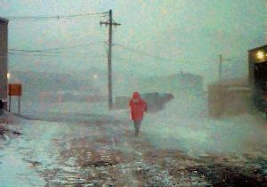 This
is a mild wind blow in Antarctica and looking down one of the
streets in Mactown. The person in this photo is wearing only
jeans, as most people around McMurdo do, because it's not far
between buildings. Most photos of storms don't come out as well
as this one. Usually you lose visibility and it tends to look
more like a bad picture than bad weather.
This
is a mild wind blow in Antarctica and looking down one of the
streets in Mactown. The person in this photo is wearing only
jeans, as most people around McMurdo do, because it's not far
between buildings. Most photos of storms don't come out as well
as this one. Usually you lose visibility and it tends to look
more like a bad picture than bad weather.
 This
picture is overlooking part of the Dry Valleys. They're called
the Dry Valleys because any snow or ice deposited around the
valleys is quickly blown away by the strong wind currents that
constantly blow through. This particular photo is taken somewhere
around the Labyrinth where deep cracks and small valleys create a
maze effect. They call it the Antarctic equivalent of the Grand
Canyon.
This
picture is overlooking part of the Dry Valleys. They're called
the Dry Valleys because any snow or ice deposited around the
valleys is quickly blown away by the strong wind currents that
constantly blow through. This particular photo is taken somewhere
around the Labyrinth where deep cracks and small valleys create a
maze effect. They call it the Antarctic equivalent of the Grand
Canyon.
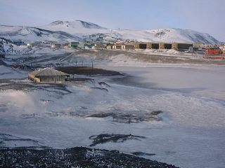 Looking down from
the cross at Hut Point, you can see the back end of Mactown and
to the center left is Discovery Hut. In front of Discovery Hut
(to the right) is The Ice Pier ( the big patch of dirt) and Back Quarters Bay.
Looking down from
the cross at Hut Point, you can see the back end of Mactown and
to the center left is Discovery Hut. In front of Discovery Hut
(to the right) is The Ice Pier ( the big patch of dirt) and Back Quarters Bay.
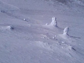 Fumerols, found
on Mount Eribus, are steaming "vents" on the side of
the mountain, which build up snow and ice around them. They often
hide huge caverns underneath, so you have to be very careful when
walking around them.
Fumerols, found
on Mount Eribus, are steaming "vents" on the side of
the mountain, which build up snow and ice around them. They often
hide huge caverns underneath, so you have to be very careful when
walking around them.
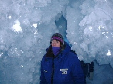 One of the fun things we do during the summer is looking
inside ice caves every now and then. They are normally
accessible cracks in the glaciers which are safe enough for us to
explore. The caves are normally full of side caverns and
passageways, there is no need for a light inside becasue of the sunlight filtering though the carvern walls like opaque blue glass . During
summer the ice, which can be thousands of years old, acts like a
big chandelier, lighting up the inside of the cave. We spent over
an hour and a half one day looking through this particular ice
cave. You may also want to look at the section about Adventures,
which will include bits about trips we got to make that year.
One of the fun things we do during the summer is looking
inside ice caves every now and then. They are normally
accessible cracks in the glaciers which are safe enough for us to
explore. The caves are normally full of side caverns and
passageways, there is no need for a light inside becasue of the sunlight filtering though the carvern walls like opaque blue glass . During
summer the ice, which can be thousands of years old, acts like a
big chandelier, lighting up the inside of the cave. We spent over
an hour and a half one day looking through this particular ice
cave. You may also want to look at the section about Adventures,
which will include bits about trips we got to make that year.
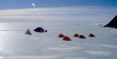
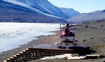 The Helicopter pad at Lake
Bonny is where the New Zealand helicopter crew got caught in a
wind that tried to slap them back onto the hello pad. Luckily
nobody was injured, but the helicopter was damaged. The crew
spent a bit of time over the next couple of weeks repairing their
machine on the spot. Fortunately they were able to and then
flew it back to the Willies Airfield. It was then transported
back home to New Zealand on a C130 for a full re-service.
The Helicopter pad at Lake
Bonny is where the New Zealand helicopter crew got caught in a
wind that tried to slap them back onto the hello pad. Luckily
nobody was injured, but the helicopter was damaged. The crew
spent a bit of time over the next couple of weeks repairing their
machine on the spot. Fortunately they were able to and then
flew it back to the Willies Airfield. It was then transported
back home to New Zealand on a C130 for a full re-service.
Antarctic rivers run cold. In some places during the summer there are actual rivers that run with snow melt but their life is short-lived. If we get too much snow melt around Scott Base, we have problems with soil erosion (believe it or not!). Many people comment on how much bare ground there is around Antarctica but summer can get warm enough to melt the snow.
 In
the Dry Valleys the winds are strong and constant. This causes
rocks to be shaped into "ventifacts", caused by the
constant abrasion of wind-blown snow and grit.
In
the Dry Valleys the winds are strong and constant. This causes
rocks to be shaped into "ventifacts", caused by the
constant abrasion of wind-blown snow and grit.
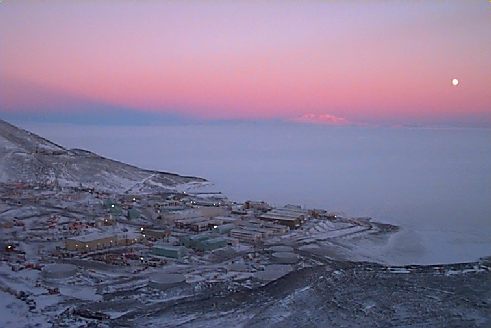
This is overlooking Mactown (looking southeast)
within days of the last sunset for the summer. Notice the shadow
created in the sky by Mt. Eribus and the 3/4 moon to the side.
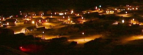
This is Mac Town by night, taken 12-June-98. I could have taken this at midday or midnight and you would not be able to tell the difference. Midwinter brings 24-hour darkness. Another week and it will be
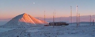 This is T Site, a radio transmission receiver site used by the
Americans. Dave and I (as well as others) often run up to this
site which is nestled half way up Crater Hill. In the background,
you can see Observation Hill with the evening sunset lighting up
its north face.
This is T Site, a radio transmission receiver site used by the
Americans. Dave and I (as well as others) often run up to this
site which is nestled half way up Crater Hill. In the background,
you can see Observation Hill with the evening sunset lighting up
its north face.
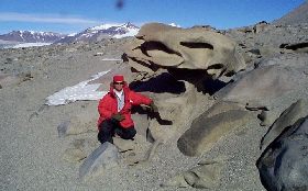
These big cliffs in the Dry Valleys are called the Diosese. Notice how the glaciers seem to spill out of the upper valleys and run down others like a thick milk shake spilled on the ground. Several of the guys on base were lucky enough to walk this valley a few years ago. Not far away is a salt water lake which takes a lot to freeze because of the salts in the ground.
 I've never been
to Vanda Station so I can't comment too much about it. Lake Vanda
has special interest for the scientists. Its normally clear, icy
surface acts like a big magnifying glass. When the sun is up, the
water below is heated to a reasonably warm temperature. It used
to be a big thing to go there and do the polar plunge but isn't
often done now.
I've never been
to Vanda Station so I can't comment too much about it. Lake Vanda
has special interest for the scientists. Its normally clear, icy
surface acts like a big magnifying glass. When the sun is up, the
water below is heated to a reasonably warm temperature. It used
to be a big thing to go there and do the polar plunge but isn't
often done now.
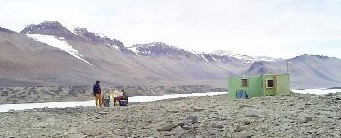
 Camping out in
Antarctica: To the right are several Skidoos covered with yellow
tarpaulins. To the left is the toilet tent and the domed
enclosure is most likely the accommodation. From the looks of the
photo they are camped next to the fuel line out by Willies Field
runway and may be doing maintenance on it.
Camping out in
Antarctica: To the right are several Skidoos covered with yellow
tarpaulins. To the left is the toilet tent and the domed
enclosure is most likely the accommodation. From the looks of the
photo they are camped next to the fuel line out by Willies Field
runway and may be doing maintenance on it.
 These are Nacreous clouds as seen from the top of Crater Hill.
Ice crystals in the upper atmosphere reflect low angle sunlight
back down and create some amazing wavy-line rainbow effects and
intensely lit spots. According to the sky scientist we had
at Scott Base, it is also when the ozone is being attacked by
ozone destroying agents such as chlorine, creating a hole in our
atmosphere.
These are Nacreous clouds as seen from the top of Crater Hill.
Ice crystals in the upper atmosphere reflect low angle sunlight
back down and create some amazing wavy-line rainbow effects and
intensely lit spots. According to the sky scientist we had
at Scott Base, it is also when the ozone is being attacked by
ozone destroying agents such as chlorine, creating a hole in our
atmosphere.
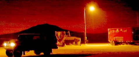 The
Pegasus runway was the first to be started this year. It's built
on top of very deep permanent ice which is then leveled out with
a big ice cutter, like you would do with a skating rink. This
photo was taken at the beginning of that process. The McMurdo
engineers have set up a generator shed, street light, smoko room
and a hitching rail for the vehicles. The light is just
starting to return to the area and Eribus is silhouetted on the
horizon.
The
Pegasus runway was the first to be started this year. It's built
on top of very deep permanent ice which is then leveled out with
a big ice cutter, like you would do with a skating rink. This
photo was taken at the beginning of that process. The McMurdo
engineers have set up a generator shed, street light, smoko room
and a hitching rail for the vehicles. The light is just
starting to return to the area and Eribus is silhouetted on the
horizon.
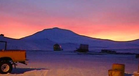 Light
is returning at a faster pace now as the sun slowly rises on this
end of the world. The light behind Eribus goes from a deep red to
a lighter yellow and pink.
Light
is returning at a faster pace now as the sun slowly rises on this
end of the world. The light behind Eribus goes from a deep red to
a lighter yellow and pink.
 When we climbed Mt. Aurora
in the summer, the digital camera froze and wouldn't operate.
However, I was able to get my normal camera to work for a while
and this is the photo I took looking back over Black Island
towards Ross Island and Scott Base.
When we climbed Mt. Aurora
in the summer, the digital camera froze and wouldn't operate.
However, I was able to get my normal camera to work for a while
and this is the photo I took looking back over Black Island
towards Ross Island and Scott Base.
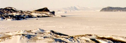
The top of Windvane Hill gives a good look back down the
West side of Ross Island. The glacier you see is the Barn Glacier
jutting out into the frozen sea. To the right is either Razor
Back Island or Little Razor Back Island.
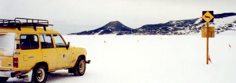
Traveling home from Pegasus Air Field you have to detour
around the sea ice and pass very close to Willies Air
Field. This is the halfway marker from Scott Base to
Willie's Air Field. Dave and I would often run out to this marker
and back from Scott Base. Running on the semi-soft snow felt more
like running on sand and took about 30 minutes each way. In
the summer, the odd runner would sometimes go all the way to
Willies and back again, but Dave nor I ever did get around to
running the full distance.
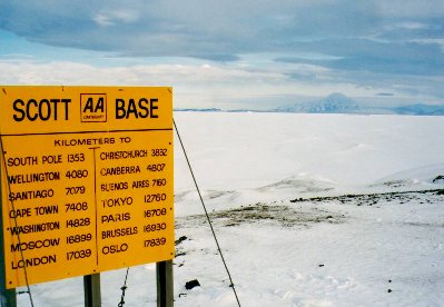 By
the Scott Base shoreline is the AA (Automobile Association)
signpost telling how far you are from various places.
By
the Scott Base shoreline is the AA (Automobile Association)
signpost telling how far you are from various places.
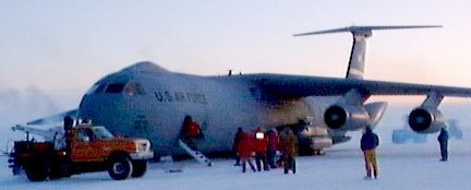 Winfly is here
and the first flights of the season bring new people and more
work for those at Scott Base and McMurdo stations.
There are only about 5 flights at Winfly and are spread over
about 10 days, if the weather allows. Flights can be
delayed during bad weather and, after each dose of bad weather or
storm, the runway has to be groomed again. These planes can
land on the ice runway with wheels but they cannot land on snow.
The grooming machines often work all day and night to leave an
optimum of a half inch of snow on the runway. The runway is about
10,000 feet long (about 2 km) and the width about three times the
wingspan of the plane.
Winfly is here
and the first flights of the season bring new people and more
work for those at Scott Base and McMurdo stations.
There are only about 5 flights at Winfly and are spread over
about 10 days, if the weather allows. Flights can be
delayed during bad weather and, after each dose of bad weather or
storm, the runway has to be groomed again. These planes can
land on the ice runway with wheels but they cannot land on snow.
The grooming machines often work all day and night to leave an
optimum of a half inch of snow on the runway. The runway is about
10,000 feet long (about 2 km) and the width about three times the
wingspan of the plane.
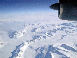 On a
flight to the Anarctic you may get a chance to look out the
window and see your new home. The plane I arrived in had few
windows and was so cramped that it just wasn't worth the hassle
to maneuver to one of the two cargo windows.
On a
flight to the Anarctic you may get a chance to look out the
window and see your new home. The plane I arrived in had few
windows and was so cramped that it just wasn't worth the hassle
to maneuver to one of the two cargo windows.
www.geocities.com/coolrunnernz/
9-3-01
Re-Edited by Shirley Baston - [email protected] - ICQ # 15167279