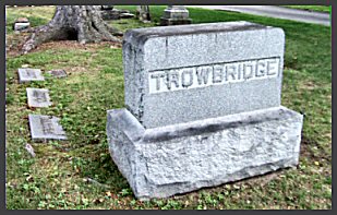
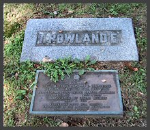
Our story begins here, at the grave site of Rowland Ebernezer Trowbridge. He is buried in the old Birmingham Cemetery (aka Greenwood Cemetery) the remains of the man to whom the Trowbridge Road Street Bridge, aka "Trodes," is dedicated. His plot is the last one in the row behind the family headstone marker.
Ghosts have homes, too. They sometimes hang out/live where they died, or where something very significant occured, something that links the apparition to the spot. The Trowbridge ghosts have an obvious link, since they jumped to their deaths at this spot. Those who saw the ghosts said they are viewed best from below, from under the bridge, and the spirits are seen walking down the tracks.
The bridge has an intriguing history of its own. The section of track we are interested in was built circa 1838 diagonally across the Trowbridge farm, owned by two of the Trowbridge brothers, chlden of S(tephen).V. Trowbridge, was one of the original settlers in Troy. The father Stephen was the very first inspector of Troy, when it became a township in 1828. Though the Trowbridge family may not have owned the property then, by at least the 1850s, the farm was owned by two Trowbridge brothers. They may have grown cherries.
A section of the original tracks from Royal Oak (Catalpa) to Charing Cross in Bloomfield Hills (then, Bloomfield Township) ran adjacent and parallel with Woodward Avenue. In 1923 state legislation passed to widen Woodward, and it was decided that the tracks would be moved roughly 3/4-mile east. The tracks ran more diagonally across the Trowbridge Farm property, roughly from the current Charing Cross to the bridge at Long Lake. Sink holes were the reason that the Trowbridge Road Street Bridge was carved so deeply by a crew of 150 men, as they needed to burrow down deeply enough to build a stable base for the tracks. A portion of the tracks south of Pontiac were destroyed by the sink holes.
Trowbridge Court ran straight across from Woodward to Kensington rather than the crescent-arch shape of the street today. The bridges involved in this project (17 bridges) were designed by an architect firm out of St. Paul, MN, A. Guthrie & Co. Most of the bridges were a copy/paste variety popular with the highway department of that time. Trowbridge Road Street Bridge was a far more complicated bridge to construct, with its false-arch design. The original intention was to eventually expand the number of tracks to four. The underside of the bridge is spacious.
Does the land have a sinister history of its own? In the 1820s when the land was first "settled," a number of different Native American tribes lived on the land (Chippewa/Ojibwa, Potawatomi, Ottawa, Miami, Saulk, Fox, and the Mascouten) and a great many Native Americans were slaughtered by the new settlers in this area's transition to a civilized society.
Not a great deal is publicly known about the people who lived on the property, or the Trowbridge family, other than a few brief sentences in books on Oakland county history. Perhaps this spot has known violence previously. Or maybe the legend starts with the youths cited in the popular stories today.
Bloomfield Hills became a village in 1927, and a city in 1932.
This is what the Michigan DOT says about Trowbridge Road Street Bridge, its historical significance and the circumstances of its construction:
"The Trowbridge Road Bridge is eligible for the National Register as a representative product of a massive engineering project that affected developmental patterns in Detroit and associated communities to the northwest. The Trowbridge Road Bridge is also noteworthy for its false-arch design."
"The Trowbridge Road Bridge was built as part of a major reconstruction of Woodward Avenue a few blocks to the west. Woodward was among the first improved roads in the state. Made into a corduroy road in 1817, it extended northwest from the nascent town of Detroit to Six Mile Road. When Pontiac was founded further to the northwest two years later, the trip from there to Detroit took two days."
"The city and county consistently improved the route, and some parts were paved with concrete for the first time in 1915. But by the late 1910s, pressure was building to significantly upgrade Woodward Avenue from downtown Detroit to Pontiac. During this period, Detroit expanded its municipal boundary from Six Mile Road to Eight Mile Road. The city made plans to widen and pave Woodward in this section, but as Wayne County Road Commissioner Edward Hines noted: "No sooner has an improvement . . . taken place than the road immediately becomes congested."
Except for Trowbridge Road Street Bridge and the Derby Bridge (in Birmingham), the tracks are mostly at or above street level. Looking north up the tracks from the bridge, one can see the tracks descending from the Long Lake bridge. And to the south, the Charing Cross bridge is built above street level. Those bridges are pictured on the photo page. You can view both of these bridges on the Images page.