Touring San Francisco
Maps of San Francisco and environs
MAPS
Cable Car Routes Districts 49-Mile Scenic Drive Golden Gate Park Neighborhoods Our Steep Streets' Grades
San Francisco MUNIcipal Railway's routes [San Francisco] Bay Area Rapid Transit's routes The Presidio Region
San Francisco BICYCLING & WALKING Guide
has color-coding (key at SouthEast corner)
indicating the steepness of our streets. It also shows what's where. It's a great map!
Best when enlarged to 200% or greater.
The useful SAN FRANCISCO MUNICIPAL RAILWAY map does not name many streets.
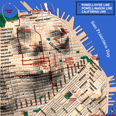
CABLE CAR ROUTES
with routes of Telegraph Hill/Coit Tower bus, Market/Wharves and Embarcadero streetcars
[San Francisco] BAY AREA RAPID TRANSIT (BART) map
NOTE: BART is useless except for Airport to/from, and out of town, getting.
SAN FRANCISCO INTERNATIONAL AIRPORT (SFO)
GOLDEN GATE PARK
The Recreation and Parks Department's map (view at 50%)
GOLDEN GATE PARK
CAVEAT: Don't look at this one unless you have some time to play with it!
Map of the THE PRESIDIO
If small, click on it.
©James Collier's inaccurate-but-nice TOPOGRAPHICAL map.
Several Districts are not identified on the above map.
[Mis-labelings include Islais Creek as “Island Creek Channel”; Masonic Avenue as “Masonic St”]
©San Francisco Convention & Visitors Bureau inaccurate-but-clear maps of San Francisco with
49-MILE SCENIC DRIVE
Unidentified Districts include Eureka Valley, Parkside, Saint Francis Wood, others;
part of Excelsior mis-labeled as “Outer Mission”; San Francisco County Line is in Crocker-Amazon.
DISTRICTS/NEIGHBORHOODS
NOTICE: The information that accompanies these wonderful maps, with absurdly drawn borders,
is an ignorable mix of fact, fiction, and fantasy with countless orthographic and grammatical errors.
Further, many neighborhoods shown are not named. Maps and “information” probably created in England.
BAYVIEW: Apparel City, Silver Terrace — CHINATOWN — CIVIC CENTER — EUREKA VALLEY: Castro
EXCELSIOR: Crocker-Amazon, Little Hollywood, Portolá, Visitación Valley
FINANCIAL DISTRICT: South o'the Slot, Union Square — FISHERMAN'S WHARF
GLEN PARK: Diamond Heights — GOLDEN GATE PARK
HAIGHT-ASHBURY: Ashbury Heights, Buena Vista, Fillmore — HUNTERS POINT
LANDS END — MARINA: Fort Mason — NOB HILL: Polk Gulch, Russian Hill — NOE VALLEY
NORTH BEACH — PACIFIC HEIGHTS: Cow Hollow — PARKSIDE
POTRERO: China Basin, South Beach — PRESIDIO — RICHMOND: Park Presidio, Seacliff, Vista del Mar
STONESTOWN: Ingleside, Merced Heights, Park Merced — SUNSET: Sunset Heights
TELEGRAPH HILL — TWIN PEAKS: Forest Knolls, Parnussus Heights
WESTERN ADDITION: Anza Vista, Cathedral Hill, Francisco Heights, Hayes Valley, Japantown
Laurel Heights, Laurel Hill, Lone Mountain, Presidio Heights
REGIONAL MAPS
Two maps of San Francisco, Eight nearby Counties, and a Regional Map
with the bays San Francisco, Bodega, Drake's, Grizzly, Half Moon, Monterey, Richardson, and San Pablo.
If not displayed, please click OUR FLAG.
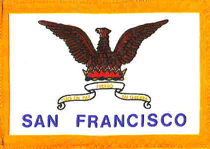
Motto in Scroll: Oro en Paz, Fierro en Guerra — Gold in Peace, Fire in War
Maps of San Francisco and environs
| Page of Contents |
Our Flag! |
San Francisco's Don't-miss sights |
Cable Car Routes Districts 49-Mile Scenic Drive Golden Gate Park Neighborhoods Our Steep Streets' Grades
San Francisco MUNIcipal Railway's routes [San Francisco] Bay Area Rapid Transit's routes The Presidio Region
San Francisco BICYCLING & WALKING Guide
has color-coding (key at SouthEast corner)
indicating the steepness of our streets. It also shows what's where. It's a great map!
Best when enlarged to 200% or greater.
The useful SAN FRANCISCO MUNICIPAL RAILWAY map does not name many streets.
CABLE CAR ROUTES
with routes of Telegraph Hill/Coit Tower bus, Market/Wharves and Embarcadero streetcars
[San Francisco] BAY AREA RAPID TRANSIT (BART) map
NOTE: BART is useless except for Airport to/from, and out of town, getting.
SAN FRANCISCO INTERNATIONAL AIRPORT (SFO)
GOLDEN GATE PARK
The Recreation and Parks Department's map (view at 50%)
GOLDEN GATE PARK
CAVEAT: Don't look at this one unless you have some time to play with it!
Map of the THE PRESIDIO
If small, click on it.
©James Collier's inaccurate-but-nice TOPOGRAPHICAL map.
Several Districts are not identified on the above map.
[Mis-labelings include Islais Creek as “Island Creek Channel”; Masonic Avenue as “Masonic St”]
©San Francisco Convention & Visitors Bureau inaccurate-but-clear maps of San Francisco with
49-MILE SCENIC DRIVE
Unidentified Districts include Eureka Valley, Parkside, Saint Francis Wood, others;
part of Excelsior mis-labeled as “Outer Mission”; San Francisco County Line is in Crocker-Amazon.
DISTRICTS/NEIGHBORHOODS
NOTICE: The information that accompanies these wonderful maps, with absurdly drawn borders,
is an ignorable mix of fact, fiction, and fantasy with countless orthographic and grammatical errors.
Further, many neighborhoods shown are not named. Maps and “information” probably created in England.
BAYVIEW: Apparel City, Silver Terrace — CHINATOWN — CIVIC CENTER — EUREKA VALLEY: Castro
EXCELSIOR: Crocker-Amazon, Little Hollywood, Portolá, Visitación Valley
FINANCIAL DISTRICT: South o'the Slot, Union Square — FISHERMAN'S WHARF
GLEN PARK: Diamond Heights — GOLDEN GATE PARK
HAIGHT-ASHBURY: Ashbury Heights, Buena Vista, Fillmore — HUNTERS POINT
LANDS END — MARINA: Fort Mason — NOB HILL: Polk Gulch, Russian Hill — NOE VALLEY
NORTH BEACH — PACIFIC HEIGHTS: Cow Hollow — PARKSIDE
POTRERO: China Basin, South Beach — PRESIDIO — RICHMOND: Park Presidio, Seacliff, Vista del Mar
STONESTOWN: Ingleside, Merced Heights, Park Merced — SUNSET: Sunset Heights
TELEGRAPH HILL — TWIN PEAKS: Forest Knolls, Parnussus Heights
WESTERN ADDITION: Anza Vista, Cathedral Hill, Francisco Heights, Hayes Valley, Japantown
Laurel Heights, Laurel Hill, Lone Mountain, Presidio Heights
REGIONAL MAPS
Two maps of San Francisco, Eight nearby Counties, and a Regional Map
with the bays San Francisco, Bodega, Drake's, Grizzly, Half Moon, Monterey, Richardson, and San Pablo.
If not displayed, please click OUR FLAG.
Motto in Scroll: Oro en Paz, Fierro en Guerra — Gold in Peace, Fire in War
| Page of Contents |
### |
San Francisco's Don't-miss sights |