|
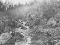
 Difficult Run near the Potomac. Difficult Run Itself Fairfax County's Stream Difficult Run has the largest watershed in Fairfax County. Accotink Creek is longer, but Difficult Run is loved by more people. Despite the ever-increasing density of population surrounding it, Difficult Run remains a beautiful stream. Difficult Run's watershed includes Reston, Oakton, Fox Vale, Wolf Trap, Vienna and parts of Great Falls. In terms of Fairfax County politics, it flows through the following districts of the county: Dranesville, Providence, Hunter Mill, and Sully. Fairfax County restricts the density of development in Difficult Run's headwaters northwest of Fairfax City. This stream looks different from day to day. During frequent flash floods, the water turns the color of milk chocolate. Where it joins the Potomac, Difficult Run looks like a mountain river. The American Whitewater Affiliation rates the rapids here as potentially lethal. Just a few miles upstream, it looks like a small river in the Midwest, meandering through ox-bow turns. The scenery along its banks varies. In the vicinity of the Browns Mill Road, the valley is wide and the shallow. Near Lawyers Road, the valley is narrower, and the sides are steeper; outcroppings of schist form cliffs. These rocks are 500 million years old. Near Oakton, Difficult Run flows through wide, flat marshes, teeming with wildlife. Difficult Run is a multi-faceted jewel, worthy of preservation. One of the goals of the Potomac River Greenways Coalition, Inc. is the preservation of the open land along the banks of Difficult Run. |
|