Cycling Cue Sheets
All cue sheets are in .pdf format. Fold vertically and then horizontally for use in a cue sheet holder.
cue.sheet.holder.jpg: How to make a proper cue sheet holder using a zip tie and a document clip.
cue.sheet.template.doc: Cue sheet template.
Brewery Starts
The Anheuser Busch Brewery is located in Cartersville Ga, just off Interstate 75. From the south take exit 296, turn right onto Cassville White Rd. then right onto Busch Dr. The brewery is on your left at the end of the road. Pull past the fence and park in the lot on your right. The good people of the brewery let cyclists park and they do use surveillance cameras so please be respectful; no unrination or trash and change in your car. North Atlanta Riding Club (NARC) meets here weekend mornings.
brewery.27.pdf: 27 mile loop through lightly traveled country roads.
brewery.45.pdf: Same as above but longer.
bbc.century.pdf: The Beautiful Backroads Century. NARC sponsored and sagged ride held in early September. This is one of the finest organized rides I have ever been on.
Brookstone Starts
Brookstone is located in Acworth, Ga, at the corner of Mars Hill Rd. and Stilesboro Rd, near the West Cobb YMCA. Take I75 to exit 269 South-West (Barret Parkway). Take Barret Parkway 3.1 miles to Stilesboro Rd. Turn right on Stilesboro Rd.and go West for 6.1 miles. Rides start in the Publix Shopping Center. From The East-West Connector, head west to Powder Springs. Head north on Hwy 176, New Macland Rd. New Macland turns into Lost Mountain which turns into Mars Hill Rd. Publix is about 10.8 miles from the initial turn onto 176.
braswell.mountain.metric.100k.pdf: Actually just short of a metric century (unless you start in my driveway), this route heads south from Brookstone to the SCT and then west to Coots Lake Trailhead for a store stop. From Coots, you will climb Braswell Mountain Rd and then decend to Hwy 61. Avoiding highway 61 via Benson, and Narroway Church, the route heads back via scenic Harmony Grove Church Rd, Cedarcrest and Burnt Hickory. This is my favorite solo summer training route. On weekend mornings, look for the triathlon crowd from Kennesaw Mountain on this route..
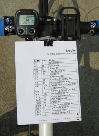
brookstone.indianmounds.redtop.acworth.51.pdf: Typical route west from Brookstone via Cedarcrest to Dabbs Bridge Rd. Crosses from Pumpkinvine Creek Valley to the Etowah River Valley via Green Ridge/Bates and over the Etowah River for a loop past the Indian Mounds. After visting the mounds, the route continues through the town of Emerson for a beautiful ride over Lake Allatoona on the Bethany Bridge and on to Red Top Mountain State Park. Descends Glade Rd. for a tour of Acworth on the way back.
brookstone.to.sct.11.7.pdf: How to get to the Silver Comet Trail from Brookstone. This is one of the first things that I figured out after moving to the area. Hooks into the SCT less than two miles from Starbucks and The Bike Shop in Hiram allowing for access to PaCO and WACO club ride start locations.
brookstone.iveygullege.dallas.sct.50.pdf: This route leaves Brookstone heading west on Due West Rd. and then south-west to Dallas via Ivey Gullege, Old County Farm, Brooks and Old Cartersville Roads. The route leaves Dallas via Polk and Mt. Olivet and enters The SCT via a short foot path at the guard rails just past the twin lakes on Mt. Olivet Rd. The route leaves the Silver Comet in Hiram and heads north, gaining elevation on its way back to Acworth. I do a few roads around Acworth (parts of the old C&B ride) to round it out to a nice even 50 miles.... "Seemed like a nice round number."
indian.mound.ride.39.7.pdf: Follows the Cedarcrest/Harmony Grove Church/Dabbs Bridge route toward Emerson, crosses the Etowah river and loops past the Etowah Indian Mounds. Return via the same route.
Coots Lake Trailhead Starts
Coots Lake Trailhead at the Silver Comet Trail is just off Hwy 6/278 near Rockmart Ga. From Atlanta, take I20 west to exit 44, Thornton Rd. Head north (and then west after passing under the Silver Comet Trail) for 29.5 miles and turn right on Coots Lake Rd. The trailhead is just past the store on your right.
coots.aragon.taylorsville.covered.bridge.48.9.pdf: Leaving the trailhead heading north, you will pass over Knox Mountain and head to the old town of Taylorsville via White River Rd. and scenic Taylorsville Rd. From Taylorsville, the route meanders down beautiful country roads, past cotton and cattle farms with hardly a car in sight. After passing the massive cooling towers of Georgia Power's Plant Bowen you will arrive at the historic covered bridge in the town of Euharlee. The route heads back to Taylorsville over winding contry roads and returns to Coots Lake via the outbound route. Look for The Green Team's "King of the Mountain" marker at the top of the short climb over Knox Mountain on the way back.
coots.2.kingston.pdf: Same as above but heading further north from Euharlee to Kingston for just over 100 kilometers (64.8 miles). Starting this ride in Hiram and taking the Silver Comet to Coots Lake adds 18 easy miles each way for an enjoyable century.
Duathlon Cycling Courses
big.canoe.duathlon.pdf: This was to be the original route for the 2005 big canoe duathlon. The bridge on Afton Rd. was not completed in time and so the route went straight up Steve Tate Hwy, right on Hwy 136 and U-turned at route 183.
chateau.elan.duathlon.pdf: Cue sheet for the 2005 Chateau Elan Duathlon.
Hiram Starts
Hiram is a hub of cycling activity for Atlanta and its western suburbs courtesy of the Paulding County Cycling Organization (PaCO) and the West Atalanta Cycling Organization (WACO). Any weekend morning you can probably pick up an aggressive AA pace club ride complete with sprints and "King of the Mountain's" by simply showing up at the Starbucks in front of Sam's Club/Home Depot or The Bike Shop a few doors down. Slower but but no less competative B and C groups roll out too. Take I20 from Atlanta to exit 44, Thornton Rd. north. Pass under the Silver comet Trail's steel bridge and go a few more miles to Starbucks on your left. Look for the little blue truck with the bike logo on the back and introduce yourself :).
coots2.kingston.pdf: This is the same cue sheet listed in the Coots Lake section above. Started from the SCT Hiram trailhead it is an easy century with the first and last 18 miles on the flat Silver Comet Trail.
killer.b.40.pdf: My own route north from Hiram to the bagel store in Acworth and back.
land.of.sunsets.century.105.pdf: The Land Of Sunsets 105 mile ride. SCT to Rockmart, local roads to Cedartown and back on the SCT to the Alabama line. Return via local roads. Several store stops along the way. Cue sheet is for a start from the SCT trailhead in Hiram, six tenths of a mile south of Home Depot on Depot Rd./Seaboard Ave.
paco.blue.loop.36.4.pdf: An awesome club ride courtesy of the guys from PaCO. Great climbs and viscious sprints. Starts at The Bike Shop, Office Max shopping center. 1673 feet of climbing.
sky.loop.with.challenge.41.6.pdf: Loop of typical Paulding County Roads. Very nice roads with suprisingly low traffic, given the location. Hilly with a nice six mile finish on the Silver Comet Trail. This is an extremely well marked route designed by Chris Pettit and recieves rave reviews by all who ride it. See atlbike.org for detailed information on bail out options and explanation of the the markings for easier or harder routes. This cue is the longer "Challenge" option.
March.to.the.Sea.pdf: Another one of my own creations at 62.8 miles (100 kilometers). North from Hiram, this route features challenging climbs with steep grades to the town of Emerson. A fantastic twisting descent leads to a beautiful crossing of Lake Allatoona over the Bethany Bridge. Spinning through Red Top Mountain State Park, the route then descends into historic downtown Acworth, most of which was burnt to the ground by General Sherman's troops in 1864. The route returns to Hiram from Acworth via Brookstone.
"The Other Way": 60.7 miles from Hiram to Buckhead and back. This ride starts with a liesurely ride on the Silver Comet Trail East, just about as far as you can go. When you reach mile zero on the trail, the fun begins... We will outsprint traffic, take the lane (and give it back when we are done!), climb (and descend) HUGE hills and pass some of the most expensive homes in Atlanta. If you go one half mile left from the turn onto West Paces Ferry Rd., you will be at the Georgia Governor's Mansion.
End.