Geography
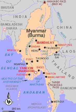
Map of Myanmar
Size & Shape
Myanmar covers an area of 671,000 sq km, roughly the combined size of France and the Netherlands. It shares borders with Bangladesh and India to the northwest, Tibet to the northeast, and China, Laos, and Thailand to the east and southeast. The country is shaped like a kite with a long tail, enclosed by a large horseshoe formation of mountain ranges and forested hills. Its greatest length from north to south is approximately 2000km, while the widest east to west distance is around 1000km.
The Bay of Bengal and the Andaman Sea form the southern boundaries of the country. The central part of the country is marked by expansive plains and wide rivers emptying into the Bay of Bengal and the Gulf of Martaban.
Rivers
Most of the country's agriculture is centered along the floodplains of the 2000km Ayeyarwady River which flows south from its source, 27km north of Myitkyina, to a vast delta region along the Gulf of Martaban south-west of Yangon. Navigable year-round for at least 1500km, the Ayeyarwady has played a major role in domestic transport and communications for centuries.
Other major rivers are the Chindwin (navigable for 792km), which joins the Ayeyarwady between Mandalay and Bagan; the Kaladan (navigable for 177km), which flows from paletwa in the southern Chin State to the Bay of Bengal at Sittwe; the Sittoung, which flows through Taungoo and meets the sea between Bago and Mawlamyaing; and the Thanlwin which has its headwaters in China, and for some distance forms the border between Myanmar and Thailand before eventually reaching the sea at Mawlamyaing. The Mekong River forms the border between Myanmar and Laos.
Mountains
The Himalayas rise in the north of Myanmar, and Hkakabo Razi, right on the border between Myanmar and Tibet, is the highest mountain in South-East Asia at 5889m. West of Bagan towards Rakhaing, Mt Victoria rises to 3053m. A wide expanse of comparatively dry plain stretches north of Yangon, but hill ranges running north-south separate the central plains from Myanmar's neighbours.
Coastline
Myanmar's coastline extends 2832km from the mouth of the Naaf River near Bangladesh to the southern tip of Tanintharyi Division near Ranong, Thailand. Coastal barrier and delta islands are common in the estuarial areas stretching from the Rakhaing State to Mawlamyaing. Off peninsular Myanmar, farther south, over a thousand continental islands dot the sea, forming an uninhabited island group called the Mergui Archipelago.
Resources
According to the World Development Report put out by the UN, Myanmar has an estimated natural forest area of 43%. The Bago Yoma, extending between the Ayeyarwady and Sittoung river valleys, is the most heavily forested area and the source of most of the country's teak. The most valued woods are teak and cherrywood.
The country's lengthy coastline provides a wealth of saltwater fisheries. The country is also rich in gems, oil, natural gas and mineral deposits.
Climate
Myanmar undergoes an annual three season cycle. The intense rainy season begins in May, peaks between June and August, and finishes in October. Rainfall in an average year varies from over 500mm along the coastlands to less than 100mm in the dry zone. The cool season, which lasts from November through February, is the most agreeable season in the Ayeyarwady delta, although temperatures can drop below freezing in the higher altitudes. March and April are hot and dry, with temperatures in central Myanmar sometimes reaching 40 degrees celsius.
Flora & Fauna
Most indigenous vegetation in Myanmar is associated with two basic types of tropical forest: monsoon forest and rainforest. The country's most famous flora includes an incredible array of fruit trees, over 25,000 flowering species, a variety of tropical hardwoods, and bamboo.
Myanmar provides habitat for a rich variety of wild animals, such as elephants, tigers, leopards, buffalo, monkeys, the Himalayan black bear, and even rhinoceros. An amazing variety of birds also abound, as do venomous insects and reptiles.
Source: Lonely Planet - Myanmar