 |
|
|
|
|
|
|
|
|
|
|
|
|
|
|
|
|
|
|
|
|
|
|
|
|
|
|
|
|
|
|
|
|
|
|
|
|
|
|
|
|
|
|
|
|
|
|
|
|
|
|
|
|
|
|
|
|
|
|
|
|
|
|
|
|
|
|
|
|
Views of Ecuador |
|
|
 |
|
|
|
|
|
|
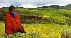
La Sierra |
|
|
|
|
|
Glaciated live and dormant volcanos, high altitude paramo grasslands, thermal springs, mountain lakes, and cloudforest form the diverse Ecuadorian Andes. Many cordilleras form the great spine of mountains, creating valleys and canyons between the mountains. |
|
|
|
|
 |
|
|
|
|
|
|
 |
|
|
|
 |
|
|
|
|
|
|
|
|
Central highlands |
|
|
|
|
|
|
|
Pastaza River near Baos |
|
|
|
|
|
|
 |
|
|
|
 |
|
|
|
|
Sunflower trees (Scalesia pedunculata) in central highlands. |
|
|
|
|
|
|
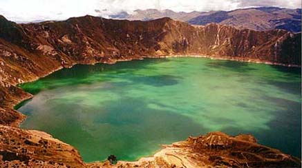
Quilatoa Lagoon near El Bacon |
|
|
 |
|
|
|
|
|
|
 |
|
|
|
Cotopaxi Volcano, 19,347 feet |
|
|
|
|
|
|
Paramos del Angel tableland along the northern border. |
|
|
|
|
|
|
|
|
 |
|
|
|
|
|
|
 |
|
|
|
|
|
|
|
|
|
|
 |
|
|
|
|
Meadow and forest |
|
|
|
|
|
 |
|
|
|
|
|
|
Cayambe Volcano near Quito. |
|
|
|
|
|
 |
|
|
|
|
Cayambe Valley below the volcano. |
|
|
|
|
|
 |
|
|
|
|
|
|
Ingapirca |
|
|
|
|
|
 |
|
|
|
|
Laguna Cuicocha in an ancient volcanic crater. |
|
|
|
|
|
 |
|
|
|
|
|
|
20, 793 foot Chimborazo Peak. |
|
|
|
|
|
Mountains south of Santo Domingo. |
|
|
|
 |
|
|
|
 |
|