Top Of Vermont Minibox
My 300th Letterbox Placed!
Top Of Vermont Minibox
My 300th Letterbox Placed!
| Placed By: | Silver Eagle |
|---|---|
| Date: | 06/18/09 |
| Nearest Town: | Stowe, VT |
| County: | Lamoille |
| Terrain Difficulty: | Moderate (via toll road & Long Trail - 500 feet elevation gain, 3 miles RT); Moderate (via gondola & Cliff Trail - steep slope, 1.5 miles RT); Difficult (via Long Trail at Smuggs - 2800 feet elevation gain, 5 miles RT) |
| Status: | alive (06/18/09) |
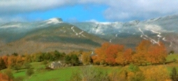
Mount Mansfield, at 4393 feet, is the highest peak in Vermont. The mountain gets its name because when viewed from the east its summit ridge resembles the profile of a human face. There are several ways to reach the summit. You can drive the Mt. Mansfield Auto Toll Road, take the Mt. Mansfield Gondola or hike via the Long Trail from Smuggler's Notch State Park off of Hwy 108. Even if you drive or take the gondola you will still have to hike to get to the top and this box.
NOTE: Always take adequate precautions (such as prodding with a stick and/or wearing gloves) before reaching into dark crevasses and holes in the wild. Before you set out read the waiver of responsibility and disclaimer.
Return to Silver Eagle's Highpoint Letterbox Series Page
Return to Silver Eagle's Vermont Letterboxes Page
Return to Silver Eagle's Letterboxing Aerie
Last updated on 06/25/2009