Devil's Backbone Microbox
Devil's Backbone Microbox
| Placed By: | Silver Eagle |
|---|---|
| Date: | 06/30/07 |
| Nearest Town: | Fischer, TX |
| County: | Comal |
| Terrain Difficulty: | Easy (flat, 50 yards RT) |
| Recommended Ink: | red |
| Status: | alive (07/05/09) |
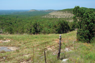
One of Texas' most scenic drives, officially RR 32, the "Devil's Backbone" is a winding, razor-backed ridge overlooking Hill Country vistas. It extends west from RR 12 just south of Wimberley some 24 miles through Fischer to near Blanco. At its highest point is a little roadside picnic area with a great view of El Rancho Cima Boy Scout Camp, and a nice place to stamp into this microbox. Nearby is an old watering hole called the Devil's Backbone Tavern, which bills itself as an original Texas Honky-Tonk.
NOTE: Always take adequate precautions (such as prodding with a stick and/or wearing gloves) before reaching into dark crevasses and holes in the wild. Before you set out read the waiver of responsibility and disclaimer.
Return to Silver Eagle's Texas Letterboxes Page
Return to Silver Eagle's Letterboxing Aerie
Last updated on 07/05/2009