Navajo Bridge Microbox
Navajo Bridge Microbox
| Placed By: | Silver Eagle |
|---|---|
| Date: | 07/31/03 |
| Nearest Town: | Marble Canyon, AZ |
| County: | Coconino |
| Terrain Difficulty: | Easy (flat, 50 yards RT) |
| Status: | alive (04/18/09) |
THIS LETTERBOX IS NOT ON NATIONAL PARK LAND, SO PLEASE DON'T CONFISCATE IT.
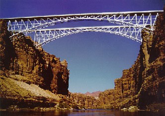
Historic Navajo Bridge spans Marble Canyon in a graceful silvery arch approximately 470 feet above the Colorado River connecting Grand Canyon National Park on one side with a Navajo Indian Reservation on the other. The 750 ft. long steel bridge has been judged to be the most historically significant bridge in Arizona. It replaced Lee's Ferry in 1929 as the only crossing of the Colorado River for a stretch of 600 miles and was still the only crossing between Glen Canyon Dam and Hoover Dam when it was taken out of service in 1995. It now serves as a pedestrian bridge providing excellent views of the canyon.
NOTE: Always take adequate precautions (such as prodding with a stick and/or wearing gloves) before reaching into dark crevasses and holes in the wild. Before you set out read the waiver of responsibility and disclaimer.
Return to Silver Eagle's Arizona Letterboxes Page
Return to Silver Eagle's Letterboxing Aerie
Last updated on 04/23/2009