 |
|
| EARTH SCIENCE |
| Continental Drift By looking at a world map, you will notice that South America and Africa seem to fit together. Scientist has found fossil remains of the same animals on both continents, and there are similarities in rock formations. Can this be a coincidence or are their scientific reasons for these similarities? This was the question asked by a German scientist named Alfred Wegener in 1912. Alfred Wegener postulated a theory of continental drift. According to Wegeners� theory, about 200 million years ago all the land on Earth was one large continent that he called Pangaea. �Approximately 180 million years ago, Pangaea began to break apart to form three separate continents.� The great land section to the north (which later became Europe, Asia, North America, and Greenland) is called Laurasia broke away from the other two landmasses. These land masses, which together he named Gondwanaland. |
| Within the past Few decades, science has altered our views and extended our knowledge. Astronauts have walked on the surface of the moon. Satellites circle the Earth sending back photographs that aid in weather forecasting and space stations are now becoming a reality for the near future. We have sent satellites through the solar system, transmitting photographs of the far-reaching solar system and beyond. �Oceanographers have charted the sea floor and discovered huge deposits of valuable minerals. Scientists have theorized about the forces that set Earth's surface in motion, unleashing the awesome power of earthquakes and volcanoes.� |
| �The northern block of Gondwanaland was to become South America and Africa; the southern block would become Antarctica, Australia, and New Zealand. A small piece broke away between the northern and southern parts of Gondwanaland and began moving northward. This would be India. These land masses continued to drift. About 65 million years ago, the continents began to look as they do today. South America and Africa had drifted apart, and soon North America and Greenland would break away from Laurasia. India was about to collide with Asia. The southern block of Gondwanaland would soon break apart into separate pieces, forming Antarctica, Australia, and New Zealand.� Wegener's hypothesis of a continental drift was not taken seriously by most scientist when first introduced into the scientific community. Over time, as geologist began to explore Wegeners ideas they were eventually accepted in a modified form. The acceptance of the continental drift theory became more prominent when geologists found fossil and magnetic evidence that the continents were no longer in the same relationship to each other as before. �More recently, evidence has turned up to show that the continents themselves have been built in part from large islands that have drifted and stuck to' the continents' shorelines.� |
| The area under Earth's surface where an earthquake emanates is called the focus. �The epicenter is the point on the surface directly above the focus.� When a quake occurs, waves shimmer out from the focus. There are several types of waves know to be created from a quake. These waves are identified by scientist as P (primary) and S (secondary) waves. P waves are longitudinal, or push-pull, waves that travel through the earth. P waves can penetrate solid and liquid material. S (secondary) waves are transverse, or shake, waves. �They also travel through the earth, but cannot penetrate liquids very well.� L waves the third type of wave is the most damaging because they travel along the earth�s surface. �Earthquake waves are recorded on an instrument called a seismograph. Since S waves travel more slowly than P waves, we can tell how far away an earthquake occurred by computing the difference in time it takes for the two waves to arrive at the seismograph. Using seismographs at three or more locations enables scientists to calculate where an earthquake has occurred. The strength of an earthquake is indicated on a scale called the Richter scale, which is based on the magnitude of the waves recorded by the seismograph. A magnitude of 2.5 is enough to be recorded but not felt; 6.0 may cause great damage; a very large earthquake registers over 8.0." |
| An earthquake is a sudden trembling or shaking of Earths crust. Earthquakes occur as a result of the movement of the crustal plates. This movement of the crust causes cracks along a line called a fault, Such as the San Andreas fault, which is at the line of demarcation between two plates. As the crust separate, the rocks on either side fold or bend until they finally break, creating the vibrations that are called an earthquake. �A particularly powerful earthquake struck Alaska on March 27, 1964, causing the death of 114 people.� Many lives were lost as a result of the tsunami a giant wave, created when the sea floor moved during the earthquake. �Tsunamis can travel across the ocean at speeds of 600 mph and reach heights of 100 feet as they crash into coastal towns and cities.� Earthquakes also produce fires, landslides and large amounts of damage to communities that are near fault lines. |
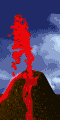
| When crustal plates merge together, one plate often sinks, forming a deep ocean trench. The mass in this plate is heated by the hot temperatures found within Earth's interior and is transformed into a molten substance called magma. Pressure exerted on the magma from above may force it up through a chamber causing the magrna to pour out through an opening called a vent. The vent forms a cone as the magma flows onto the earths surface. As the magma pours out, it changes into a substance called lava. |
| "Volcanoes also appear where crustal plates are separating, such as at the mid-ocean ridge. As the lava pours out through openings, it forms new sea floor and may build up into huge cones. Sometimes a cone above the mid-ocean ridge also breaks the water's surface, thereby forming an island.. Volcanoes can also be formed in the middle of a crustal plate. There are different types of volcanic eruptions, resulting in various kinds of volcanic cones. Sometimes the lava flows quietly along the surface, creating a shield cone. Magma does not always flow easily, and it can plug up an opening to the surface. If gases from the magma build up, they may eventually force it through the opening with a violent explosion. Volcanic materials can then be seen shooting into the sky creating a spectacular display. These materials include cinders, ash, and larger fragments called bombs. They build up around the volcanic opening forming a cinder cone. A third type of volcanic cone is a combination of lava and cinders. It is called a composite cone. At the top of a volcano is a depression called a crater. When a volcano becomes inactive, the crater may fill with water forming a lake." |
 |
| Volcanoe Movie |
| Earthquake |
| Plate techtonics |
|
| Earth Movie |
| Volcanoes |
 |
|
| Techtonic Movie |
| Volcanic activity occurs along the boundaries between plates, just as earthquakes do. In fact, surrounding the Pacific Ocean, in the same area as the earthquake belt is a circle of volcanoes that is called the "Ring of Fire." |
| Rocks and minerals |
| Waller Junior High |
| "The rock cycle shows the relationship between the three types of rocks. Igneous rocks are formed when magma or lava cools and solidifies. Common igneous rocks are granite, pumice, and obsidian. When igneous rocks are broken down, they form sediments. Af-ter these sediments are compacted under pressure or cemented together by dissolved minerals, they form sedimentary rocks. These include sandstone, shale, and limestone. Some sedimentary rocks are also formed almost entirely from the remains of living organisms. Coal is a well-known example. The action of pressure, heat, and chemicals in the environment can transform igneous and sedimen-tary rocks into metamorphic rocks. Common metamorphic rocks are marble and slate." |
|
 |
| Rock Cycle Movie |
| This web page design was created from public domain graphics and exist for the sole purpose of curriculum correlation and the expansion of learning. Resource topics have been "quoted" in part from "The Student Handbook" Webster�s New World Dictionary: Basic School Edition formerly Webster�s New World Dictionary, The Southwestern Company 1992. Web links represented on this site were randomly selected to support topic content. Waller Junior High School is a non-profit organization who seeks no revenue or compensation for the creation of this web site or any other frame within its domain. |