Sedimentation:
4.3.9. Rameshwaram Island sand spit
‘East of Rameshwaram, a long sand spit of about 20 km
length is formed and it tends to grow longer and wider. The width of this sand
spit is about 2 km near Uthalai, reduced to 1250 m at Mukkuperiyar, 750 m at
Dhaushkodi and 150 m at just east of Arimunai and converges on the tip at
Arimunai. The beach berm is found to be highly elevated along the sand spit
bordering GOM, but very low and flat along the side bordering Palk bay. There
is a marked depression in the sand spit level between Palk Bay and GOM, between
Dhabushkodi and Arimunai. Due to such level difference, the water overflows
during spring tide particularly from Bay carrying the fine sediment to the
backshore regions. Most of the time, the water is stagnant and remains along
the trough of the spit. This low lying region is fully occupied by water column
during monsoon season.’ (NEERI EIA, p-1.12)
4.3.10. Sediment Load to Palk Bay and Gulf of Mannar
‘The sediments carried by the rivers and by the surf zone
currents as littoral drift get partly deposited in permanent, semi-permanent
and temporary sinks along the Indian coast. The Gulf of Kachchh, Gulf of
Khambhat, Gulf of Mannar, Palk Bay and Sandheads act as major sinks. In order
to identify the extent of their significance for the sediment deposition, a
study was undertaken to evaluate the long-term sediment deposition in the above
regions.
Vaigai, Vaishali and Valryar rivers and the littoral
transport by various sources from the northern part of the Tamil Nadu coast are
the major sediment sources entering the Palk Bay region. It is largely occupied
by sand banks, numerous shoals, sand spits and islands. Occurrence of cyclonic
storm during north-east monsoon is common in the Nagapattinam–Poompuhar region,
which causes an erosion along this region. The sediments are transported
southerly and deposited in the Palk Bay. Low wave action inside the bay and
protection from the southerly waves encourages the deposition of sediment. In
the present study, the estimation based on eq. (1) covering the area of 117 km
× 105 km, shows that 0.3 × 10¹⁰ m3 sediment got deposited
over a period of 51 years. Assuming that the rate of accumulation is uniform
over the years, it is estimated that between the years 1931 and 1982, the
sediment deposition has caused a reduction in water depth of about 0.32 m, i.e.
0.006 m per year. The depositional feature observed in the present study agrees
with the formation of very shallow areas in the Palk Bay. The enlargement of the
Manamelkudi sand spit and the emergence of sand banks between Point Calimere
and Point Pedro (Sri Lanka) across the entrance of the Palk Bay are the
evidences of the depositional features occurring in this region. Usha and
Subramanian stated that the accretion pattern was observed in the Palk Bay at
Ammapattinam, Mandapam and Rameswaram.
Loveson et al. have discussed that large amounts of sediments
from the pediments are removed constantly by rainfall and carried by minor
rivers and dumped into the Palk Bay.
Along the Gulf of Mannar, the sea–land boundary is almost
uniform and regular but for inundation in a few places, where it is intercepted
by rivers forming tidal inlets. Tambraparni, Vembar and Vaipar and some other
inlets are present in this region. At present, Vembar river is not supplying
sediments into the sea, except during the rainy days in the north-east monsoon
period. Wave action is low during most of the time and hence, the formation of
sand dune is common in this region. The estimation using equation (1) covering
an area of 19.5 km × 13.5 km at the Gulf of Mannar, shows that 0.02 × 10¹⁰
m3 sediment got deposited over a period of 75 years. Assuming that
the rate of deposition is uniform over the years, it is found that the
deposition between years 1906 and 1981 has caused a reduction in water depth of
about 0.72 m, i.e. 0.010 m per year. There are a number of coral banks and
islands present in the Gulf of Mannar. Formation of sandy islands off Tuticorin
region shows as sinks having accumulation of sand. Large beach storage of sands
between Manapad and Tiruchendur, Vembar and Valinokkam and along Rameswaram
island indicates depositional features of the littoral sediments. (P.
Chandramohan, B. K. Jena, and V. Sanil Kumar, “Littoral drift sources and sinks
along the Indian coast”, in CURRENT SCIENCE, VOL. 81, NO. 3, 10 AUGUST 2001,
p-295)
4.2.11. Study of suspended sediments using remote sensing
Prakash Chauhan et al., have used remote sensing
technique to study suspended sediments along the Tamil Nadu coast both during
the monsoonal (ie., North East monsoon; imagery dated 17-12-1990) and the
non-monsoonal periods (image dated 18-04-1990). The maps they have prepared
will be useful here for us and hence they are reproduced here.
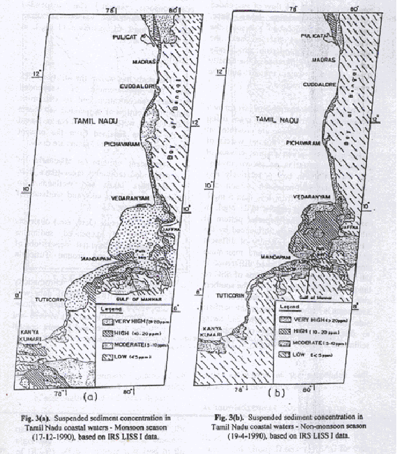
They have noted that ‘during the non-monsoon season the
sediment boils were observed near Vedaranyam and Mandapam.’ This they say ‘may
be attributed to the difference of the density of the different water masses
and the prevailing current direction.’ ( Prakash Chauhan, Sailesh Nayak,
R.Ramesh, R.Krishnamoorthy, S.Ramachandran, “Remote Sensing of Suspended
Sediments along the Tamil Nadu Coastal Waters”, in Photonirvachak, Vol.24,
No.2, 1996, p-105-114).
An attempt to study the sedimentation dynamics using
remote sensing off the Vedaranyam coast has been made by Usha Natesan recently.
(‘Role of satellites in monitoring sediment dynamics’, in CURRENT SCIENCE, VOL.
86, NO. 8, 25 APRIL 2004, p-1068-1069). Let us note the salient points from her
article:
“Vedaranyam, the study area is located in the southeast
coast of India and has a peculiar projection, which is of interest for geologic
and geomorphic studies. Tamil Nadu coast experiences a climate strongly
influenced by the southwest (June–September) and northeast (October–December)
monsoons. Formation of Point Calimere projection is due to two constantly
opposing wave directions, such as northeast and southeast, with one set of
waves predominant over the other. Further, the foreland formation is determined
by the rate at which the stream delivers the sediment and the rate at which the
waves can winnow and move the sediments in either direction away from the
mouth. The coastline is consequently affected predominantly by waves from the
northeast. This is clearly reflected by the shape of the foreland, which has
veered windward.
Sediment distribution at Vedaranyam during different seasons is depicted in Figure 2 a–c. From the figures, the direction of sediment movement can be clearly identified. Sediments move towards north during southwest monsoon (Figure 2 a, b) and vice versa during northeast monsoon (Figure 2 c). As the sediments are transported by the longshore currents, the directions indicate the movement of currents. The above observations from satellite data agree with the longshore current direction perceived through conventional methods.
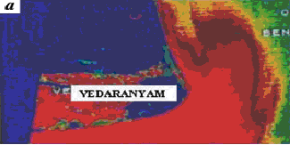
Fig. 2.a. Sediment distribution at the onset of SW monsoon
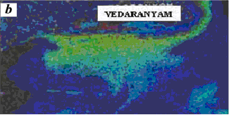
Fig. 2. b. End of SW monsoon
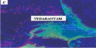
Fig. 2. c. Sediment distribution during NE monsoon
Table 1. Data products
used
Date of acquisition
Sensor Bands
Season
13–06–1988 TM 3 Onset of southwest monsoon
28–09–1983 MSS FCC 4, 2, 3 End of southwest monsoon
23–11–1989
MSS FCC 4, 2, 3 during
northeast monsoon
With the onset of southwest monsoon, sediments were
disturbed considerably (Figure 2 a). Tidal flats at Vedaranyam acting as
a source for sediment is clearly identified from the image. Daniel observed
that the sediments are discharged from tidal flats due to soil erosion. The
retreat of seawater eroding the banks of tidal flats contains high amount of
sediments in suspension. This appears bright red in colour around the mouth of
tidal flats. As the sediments move towards the north due to the longshore
currents, their concentration is reduced which is indicated by yellow colour in
Figure 2 a. At the end of the southwest monsoon, initial disturbances
are very much reduced. Sediments moving towards the north are obstructed by the
projection at Vedaranyam (Figure 2 b). Therefore, it takes a turn near
that tip and then follows the coastal configuration.
In contrast, during the northeast monsoon season,
sediments transported from north are unable to take a bend around the
Vedaranyam tip and hence dissipate a greater part of it (Figure 2 c). A
portion of the sediment is moving towards the east and the rest of it moves
downsouth of Vedaranyam along with the longshore currents.
From the conventional data seasonal sediment distribution
patterns in near-shore/ offshore are almost impossible to obtain. Satellites
are the only source of providing such information. The present study proves
that the satellites play a significant role in monitoring the sediment
dynamics.”
4.2.12. Physico-chemical parameters of Palk Bay
“This
area is under the spell of both southwest and northeast monsoon. Southwest monsoon
contributes little towards the total annual rainfall of this area. Rain is
moderate to heavy during October to January (northeast monsoon). The mean
annual rainfall varies from 820 to 1650 mm. The monthly average temperature of
the waters of the Palk Bay ranges between 24.6° and 29.1°C (minimum during
December and the maximum during May). The tidal elevation is around 1m. Palk
Bay is practically calm except during the northeast monsoon when turbulent
condition prevails (Gopinadha Pillai, 1969). The salinity of the water
decreases gradually along an axis in the southwest direction running from the
strait. High saline water is ‘pocketed’ in the south-west corner of the bay.
This may be due to the incursion of the Gulf of Mannar water through Pamban
pass. The density of the water also decreases along an axis on the southwestern
direction from the Strait.
The
North-east wind velocity at Nagapattinam is about 8 to 10 knots (North of Palk
Bay) and at Pamban the wind strength reduces between 2 and 4 knots (South of
Palk Bay). Temperature, salinity, density and dissolved oxygen values of the
surface waters of the Palk Bay would indicate that the Bay of Bengal waters
entering into the Palk Strait influence the hydrographic condition of the Palk
Bay, unlike the Gulf of Mannar waters whose influence on the hydrological
parameters of the Palk Bay is only minor (Murty, A.V.S. and P. Udayavarma,
1964. The hydrobiological features of the waters of Palk Bay during March. J. mar. biol. Ass. India, 6(2):7-216.).
The bottom
sediments of Mandapam consist of silt and clay, clayey silt and sand, fine to
medium sand, coarse sand and coarse sand with gravel. Distribution of various
size classes indicates that the offshore sediment in this area is usually
unimodal with the primary mode around 1.5 to 2 (medium sand) and a secondary
mode around 3.5. Beach samples have prominent mode around 2.25, 1.75, 2.75 and
3.25 suggesting the polymodal nature of the sediments. Grain size parameters of
the Palk Bay samples near Mandapam are shown in Table 28. The distribution
patterns of heavy minerals are shown in Table 29 (Mallik, 1983). Most of the
offshore areas contain a high amount of opaques (16-80%) with maximum
concentration in small patches. Majority of opaques consist of ilmenite. Other
minerals are magnetite, rutile, hydroxide of iron and minor amounts of pyrite
(Mallik, 1983). (p-58)
Inshore
waters of the Palk Bay during the monsoon become muddy due to the presence of
suspended sand and silt stirred up from the sandy shore by wave action. The
large degree of silt settlement has a remarkable effect especially during the
northeast monsoon. Cyclonic winds during monsoon season, with high velocity,
cause enough mechanical damage to the corals of this area. Huge quantity of
silt settlement during the northeast monsoon has a remarkable effect on the
distribution and diversity of the coral reef associated plants and animals.
(p-66)” (‘CORAL REEFS OF INDIA’
- State-of-the-art report, ENVIS Publication Series : 4/2001, ENVIRONMENTAL INFORMATION SYSTEM CENTRE, Centre of Advanced Study in Marine Biology,
Parangipettai - 608 502, Tamil Nadu, India)
4.2.13. Longshore currents
and sediment transport
“The objective of the work was to study the variations in
wave climate based on the data collected in two different years, longshore
currents and sediment transport along the Nagapattinam coast.
The daily variations of longshore current estimated based
on Longuet–Higgins equation (VL) and Galvin’s equation (VG) with
the measured current at three stations shows that the average longshore current
speed was 0.25 m/s at all stations, and it was predominantly towards north
during March–October and towards south during November–February. This matches
with the earlier study carried out in the region.
During 1998–99, strong longshore currents (> 0.5 m/s)
were observed in November and December. Longshore current was relatively weaker
(< 0.5 m/s) during the rest of the year. During 1995–96, strong longshore
currents (> 0.6 m/s) were noticed in May, June, November and December.
Longshore current was relatively weaker (< 0.3 m/s) from January to April.
The computed longshore current speed estimated based on Galvin and
Longuet–Higgins was about 50% of the measured one. The average correlation
coefficient between measured and computed data was around 0.75.
The annual longshore sediment transport was 0.175 × 10⁶
m3 in the northerly direction (March to October) and 0.273 × 10⁶
m3 in the southerly direction (November to February). The annual net
sediment transport was 0.098 × 10⁶ m3 in the southerly
direction and the annual gross sediment transport was 0.448 × 10⁶ m3.
The study shows that the average annual net sediment
transport was 0.095 × 10⁶ m3 in the southerly direction
and average annual gross sediment transport was 0.432 × 10⁶ m3.
The net sediment transport is towards the south, since the wave activity is
strong mainly during the northeast monsoon period for this coast. The annual
net sediment transport computed using the estimated breaker angle gives a value
of 0.098 × 10⁶ m3 and the difference between the
estimated sediment transport rates based on the two methods is around 3.5%.
This is due to error in observation of the surf zone width, which is based on
visual observation. Also the wave–wave and the wave– current interactions in
the surf zone are not considered. Hence the sediment transport rates estimated
based on CERC formula using the measured wave characteristics can be taken as
the representative value for this coast.
An earlier study shows that transport rate was around 0.1
× 106 m3/month in November and December, and was low
(< 0.03 × 10⁶ m3/month) in March, April and July. The
predominant direction of transport is northerly from March to October and
southerly from November to February. Though the annual gross transport was
found to be 0.6 × 10⁶ m3/year, the annual net transport
was very low showing less than 0.006 × 10⁶ m3/year
(towards the north). The difference in longshore sediment transport rates
between the present study and the earlier study was that in the present study
the wave direction of the sea and swell waves was considered in estimation,
whereas it was neglected in the earlier study. The energy at the second peak
was more than 50% of that at first peak in 46% of the data collected. The coastal
inclination of the study area is 359° with respect to north. A wave direction
more than 89° will cause a northerly sediment transport and one less than 89°
will cause a southerly transport. The average direction of sea waves was 106°
and that of the swell waves was 99°. Hence a small error of the order of
0.5° in the estimate of the breaker angle may cause a change in direction of
the sediment transport rate. The error in wave directions can lead even to a
wrong direction for the net calculated sediment transport. The present
alignment of the coastline is found to be sensitively balanced, since any
slight increase in approaching wave angles may significantly increase the
volume and may also alter the direction of sediment transport in this region.
For a coastal inclination of 4° with respect to the north (5° more than the
present alignment), the net sediment transport increases to 1.85 times the
present value, and for 354° (5° less than the present alignment) the value
reduces to 0.12 times the present value.
It is important to notice that no cyclone had occurred
during both the study periods, which is otherwise common during the northeast
monsoon period. It has been observed that for the occurrence of every cyclone,
there was a permanent loss of beach due to erosion1. As the Palk Bay is well
protected for southerly waves, no mechanism is set to transport these deposited
materials towards the north.
The comparison of the wave data collected during 1995–96
and those collected during 1998–99 shows that the statistics of the wave
parameters was almost the same during both the periods, but the events did not
occur at the same time. The average value of the breaker angle for the sea
waves was – 3.3° and that for the swells was 2°; the breaking sea and swell waves
were mainly from the southerly direction during March–October and mainly from
the northerly direction during the rest of the year. The ratio of spectral
energy at the first and second spectral peaks estimated shows that the energy
at the second peak is more than 50% of that at first peak in 46% of the data
collected in 1995–96 and 43% collected in 1998–99. The daily longshore currents
measured show that the average longshore current speed was 0.25 m/s; the
longshore current was predominantly towards the north during March–October and
towards the south during the rest of the year. The difference between the
estimated sediment transport rates based on the two methods is around 3.5%.
This is due to the error in observation of the surf zone width. The annual net
sediment transport was 0.098 × 10⁶ m3 in the southerly
direction and annual gross sediment transport was 0.448 × 10⁶ m3,
and this contributes to the supply of sediment to the Palk Bay.” (V. Sanil
Kumar, N. M. Anand and R. Gowthaman, “Variations in nearshore processes along
Nagapattinam coast, India”, in CURRENT SCIENCE, VOL. 82, NO. 11, 10 JUNE 2002,
p-1381 – 1389)
4.2.14. Studies conducted on the Wave Climate, Tides and Currents by the
NEERI EIA
‘The winds blowing over the ocean surface has the direct
effect on wave generation as it is related to wind speed, extent of fetch and
wind duration. The south west monsoon influences this pattern from June to
September. The average speed of the wind during south west monsoon period is
about 35 km per hour frequently rising up to 45-55 km per hour. The average
speed of the wind during north east monsoon (October to January) prevails
around 20 km per hour. Tropical storms known as cyclones frequently occur in
the Bay of Bengal during October to January.
Wave Measurement
The observations on wave measurement show that
significant wave height varied from 0.46 to 1.12 in March, 0.33 to 1.18m in
April, 0.46 to 1.74 m in May, 0.71 to 1.78 m in June, 0.68 to 1.6 m in July,
0.68 to 1.49 m in August, 0.64 to 1.76 m in September, 0.54 to 1.35 m in
October, 0.40 to 1.13 m in November, 0.40 to 1.12 m in December, 0.35 to 1.03 m
in January and 0.35 to 1.23 m in February.
The maximum wave height varied from 0.67 to 1.78 m in
March, 0.44 to 1.73 m in April, 0.66 to 2.81 m in May, 0.98 to 2.72 m in June,
0.91 to 2.45 m in July, 0.89 to to 2.48 m in August, 0.89 to 2.96 m in
September, 0.66 to 2.94 m in October, 0.59 to 1.60 m in November, 0.48 to 1.73
in December, 0.47 to 1.68 m in January and 0.45 to 1.79 m in February.
The wave direction (with respect to north) mostly
prevailed 1400 to 2300 in southwest monsoon (June to
September), 850 to 1500 during north east monsoon
(October to January), and 900 to 2000 during fair weather
period (February to May). The wave direction is highly variable in January and
May. The zero crossing wave period predominantly varied 3 to 8 s in December to
April, 4 to10 s in May and 4 to 9 s during rest of the year.
Wave refraction
Arimunai to Vedaranyam
This segment of the coastline lies in Palk Bay and waves
propagating from south (during south west monsoon and fair weather period) do
not enter this region. Studies are indicating that even during the north east
monsoon, waves are found not entering the bay and get attenuated across the
shoals of middle banks and south banks between Vedaranyam and Matakal (Sri
Lanka). Part of wave energy with less magnitude enters the bay through Pedro
Channel and reach the coast between Puduvalasai and Gopalpatnam. Wave
refraction between Arimunai and Vedaranyam during NE monsoon is shown in the
following figure.
Wave Period
During SW monsoon, the wave period predominantly
persisted 9 to 10 s between Vembar and Keelamundal, and 6-8 s between Uthalai
and Dhanushkodi. During the NE monsoon, it predominantly persisted 5-10 s
between Vembar and Keelamundal, and 5-8 s between Uthalai and Dhanushkodi east.
In fair weather period, it remained 6-10 s along Vembar to Keelamundal and 9-10
s along Uthalai to Dhanushkodi. The study shows that the waves approaching the
coastline consist of both seas and swells.
Tides and Currents
The tides in this region are semidiurnal. The various
important tide heights with respect to chart datum near Pamban pass are as
follows:
Mean Higher High Water Springs = 0.70 m
Mean High Water Neaps = 0. 48 m
Mean Sea Level =
0.41 m
Mean Low Water Neaps = 0.32 m
Mean Low Water Springs = 0.06 m
It shows that the average spring tidal range is about
0.64 m and the neap tidal range is about 0.16 m.
Longshore Currents
The longshore current speed remained weak (< 0.1 m/s)
throughout the year between Keelamundal and Vedalai and along the northern
coast of Rameshwaram from Arimunai to Ariyaman. Consequently, it was relatively
moderate (>0.1 m/s) throughout the year between Sippikulam and Naripaiyur
and along the southern coast of Rameshwaram i.e. from Uthalai to Mukkuperiyar.
The spit between Dhanushkodi and Ariyaman in Gulf of
Mannar experienced relatively stronger currents during fair weather period
(March to may) and remained weak during southwest monsoon and northeast monsoon
periods (June to February). It indicates that the stronger currents prevailing
in the adjacent coasts during SW/NE monsoons becoming weaker between
Dhanushkodi and Arimunai. This phenomenon of sudden weakening of littoral
currents causes the littoral drift to deposit and form series of sand shoals
near Arimunai. Such prolonged deposition of littoral drift over many years can
be attributed to formation of numerous islands and shallow shoals across the
strait between Arimunai and Talaimannar (SriLanka) called Adam’s Bridge.
The Uthalai coast facing Gulf of Mannar experienced
stronger longshore currents (0.2 – 0.5 m/s) throughout the year, followed by a
segment of the coast between Vembar and Naripayur (0.2 – 0.4 m/s) with exposure
to relatively high wave energy environment.
The prevalence of weak longshore currents between
Keelamundal and Vedalai is causing deposition of littoral drift on either side,
as evidenced by the occurrence of many offshore islands and submerged shoals.
Although the Pamban Pass, connecting Palk Bay and Gulf of
mannar break the continuity of longshore current between the mainland and
Rameshwaram Island, the magnitude of the current on either side of Pamban Pass
is found to be very weak. This reduces the volume of littoral sediments
approaching Pamban Pass which in turn reduces the quantity of sediment passing
through Pamban pass from Gulf of mannar to palk Bay.
The longshore current direction prevailed northerly
during SW monsoon and fair weather period, and southerly during NE monsoon
between Sippikulam and Uthalai. The entire coast of Rameshwaram facing Gulf of
Mannar, experienced the current in the westerly direction throughout the year,
except in June, july. This phenomenon of northerly currents along the mainland
and westerly current along Rameshwaram creates a zone, wherein, most of the
littoral drift will get deposited. Only a fractional proportion is expected to
move from this region by tide induced currents towards the Adam’s Bridge and in
turn the quantity of sediment entering Palk Bay from Gulf of Mannar. These
sediments deposited at shoals is supplied back to the littoral system for the
mainland, when the longshore currents move towards south during the ensuing
monsoon.
Although the longshore current was extremely weak along
the sand spit facing Palk Bay, it tends to be easterly during SW monsoon/fair
weather period and westerly during NE monsoon. Similarly, at Ariyaman, the
longshore current direction was southerly during SW monsoon / fair weather
period and northerly during NE monsoon, indicating just opposite to the
phenomenon observed in Gulf of Mannar. Such processes once again indicate the
accumulation of littoral drift on either side of Rameshwaram Island during SW
monsoon and removal during NE monsoon making this region as a sediment storage
reservoir.
Ocean Current Studies
Continuous measurements on tidal current speed and
direction were carried out for three seasons at 4 locations viz., 1) stn. C1 –
off Arimunai-Adam’s Bridge, 2) stn. C2 – off Uthalai (Gulf of mannar), 3) stn.
C3 – Pamban Pass, and 4) stn. C4 – of Tharuvai (Palk Bay). The measured
currents were resolved into parallel and perpendicular components with respect
to the coastline.
SW monsoon (June to September)
Near Arimunai (stn.C1) the average current speed occurred
around 0.2 m/s with the maximum and minimum speed of 0.3 m/s and 0.05 m/s
respectively both at surface and bottom. The variation of current direction had
not followed the tidal phase. It showed consistent northwesterly flow over one
tidal cycle and changed to southeasterly flow for the subsequent tidal cycle.
It indicates that current shifted its flow direction for alternate tidal cycles
rather than flood and ebb tidal phases. The shore parallel component of
currents indicates that for larger tidal range, the flow was in westerly
direction and for small range in easterly direction. The shore perpendicular
component of currents indicates that the flow consistently existed from Gulf of
Mannar into Palk Bay. The northwesterly and south westerly currents over
different tidal cycles were found to bw equally predominant.
At Uthalai (stn.2) in GOM, the average current prevailed
around 0.1 m/s with the maximum and minimum of 0.2 m/s and 0.05 m/s
respectively. Similar to Stn.C1, the bottom current was seen responding to
tides flowing east over one tidal cycle and west during the subsequent tidal
cycle. The direction of flow was predominant in southeasterly direction for
larger tidal range and north westerly direction for small tidal range. The
shore parallel component of currents indicates that the flow shifted in
southeast and north west both at surface and bottom. The shore perpendicular
component of currents indicates that the flow shifts towards north east and
south west both at surface and remains consistently northeast at bottom.
The current speed near Pamban Pass (stn.C3) was found to
be strong showing an average of 0.5 m/s, with the maximum of 1 m/s and minimum
of 0.1 m/s. Current direction remained consistently northeast flowing from GOM
into Palk Bay. Variation of current speed shows that the magnitude of current
speed was more during flood and less during evv tide indicating the influence
of tides over the seasonal unidirectional flow. The shore parallel component of
currents indicates that the flow is into Palk Bay with high speed during flood
tide and low speed during ebb tide. The shore perpendicular component of
currents indicates that the flow is across the Pamban with high speed during
flood tide and low speed during ebb tide.
At Tharuvai (stn.C4), the average current speed of 0.2
m/s with the maximum of 0.3 m/s and minimum of 0.1 m/s were observed both at
surface and at bottom. The flow was unidirectional towards south east but the
current speed varied with tidal phase. Current speed was high during flood tide
and low during ebb tide indicating the strong influence of seasonal circulation
current towards northeast during south west monsoon. The shore parallel component of currents indicates that the flow
was towards southeast at surface and bottom. The shore perpendicular component
of currents indicates the flow was towards northeast both at surface and at
bottom.
The measurement shows that during SW monsoon when tidal
range is large, the opposite direction of flow prevails between Adam’s Bridge
(stn.C1) and Uthalai (stn.2) would cause the water mass to flow from the GOM to
Palk Bay. This flow would transport sediments into Palk Bay from GOM. On the
other hand, when the range is small, the divergence of flow occurring near the
Adam’s Bridge and Uthalai would initiate a flow from Palk Bay into GOM through
Adam’s Bridge.
Northeast Monsoon (October to January)
Near Arimunai (stn.C1), current was generally weak
showing an average of 0.1 m/s, with the maximum of 0.2 m/s and minimum of 0.05
m/s. The flow direction remained unidirectional towards west both at surface
and bottom. The current speed increased during flood tide and reduced during
ebb tide. The shore parallel component of currents indicates that the flow was
consistently towards northwest at surface and bottom. The shore perpendicular
component of currents indicates the flow prevailed northeast at surface and
south west at bottom.
The variation of currents at Uthalai (stn.2), showed an
average current speed of 0.08 m/s, with the maximum of 0.15 m/s and a minimum
of 0.04 m/s. The bottom flow was nearly unidirectional towards southeast. The
shore parallel component of currents indicates that the flow was oscillating in
southeast and northwest at surface and remaining consistently southeast at
bottom. The shore perpendicular component of currents indicates that the flow
was towards northeast both at surface and bottom.
The currents at Pamban pass (stn.C3) prevailed strong
with the average of 0.1 m/s, maximum of 1.4 m/s and minimum of 0.5 m/s.
Currents remained consistently unidirectional around 2250. The
change in tidal phase caused the variation in current speed showing stronger
currents during ebb tide and reduction in current speed during flood tide. It
indicates that the flood tide propagates fro GOM to Palk Bay and vice versa.
The shore parallel component indicates that the flow was consistently from Palk
Bay into GOM both during ebb and flow tides. The shore perpendicular component
of currents indicates the flow was across the Pamban from Rameshwaram to
Mandapam.
The current was found to be weak off Tharuvai at Palk Bay
(stn.4) showing the average speed of 0.1 m/s, maximum of 0.13 m/s and minimum
of 0.04 m/s. Similar to stn.C3, the current flow was unidirectional towards 2500,
but the speed was high during ebb tide and low during flood tide. The shore
parallel component of currents indicates that the flow was towards northeast
both at surface and bottom. The shore perpendicular component of currents
indicates that the flow was towards southwest both at surface and at bottom.
The observation during northeast monsoon indicates thet
the current flow was more influenced by seasonal flow than by tides. Stronger
currents were observed during ebb tides flowing from Palk Bay into GOM through
Pamban pass. The currents were generally weak in GOM and Palk Bay (stns.C2 and
C4). Significant flow from Palk Bay was observed through Adam’s Bridge also.
Such current pattern during NE monsoon can transport and exchange the sediments
from Palk Bay into GOM.
Fair weather period (February to May)
The current at Arimunai (stn.1) was generally weak
showing average of 0.1 m/s, with the maximum of 0.2 m/s and minimum of 0.05
m/s. The current flow was found to be unidirectional towards northwest both at
surface and bottom. The shore parallel component of currents indicates that the
flow was towards northwest both at surface and at bottom. The shore
perpendicular component of currents indicates the flow was changed in direction
in north east and south west both at surface and bottom.
At GOM (stn.C2), the current was weak with average of 0.1
m/s, maximum of 0.2 m/s and minimum of 0.04 m/s. The flow remained
unidirectional consistently towards 3050, but the current speed
varied randomly between 0.04 and 0.12 m/s. The shore parallel component of
currents indicates that the flow was towards northwest both at surface and
bottom. The shore perpendicular component of currents indicates the flow
changed the direction from northeast to southwest both at surface and bottom.
The flow through the Pamban Pass (stn.C3) was quite
distinct, showing the average speed of 0.3 m/s, maximum of 0.6 m/s and minimum
of 0.04 m/s. Current flow was noticed towards 450, i.e., into Palk
Bay during flood tide and towards 2250, i.e., into GOM during ebb
tide. The shore parallel component of currents indicates that the flow was into
Palk Bay during flood tide and into GOm during ebb tide. The shore
perpendicular component of currents indicates the flow was changing its
direction across the Pamban Pass between Mandapam and Rameshwaram.
During fair weather period, the change in current was
observed over the tidal phases at Pamban Pass. The study shows that the current
flows mostly parallel to the coast. The general circulation of current in
northwesterly direction dominates the tide induced current. This would help the
sediments to move by tide induced currents from GOM to Palk Bay prevailing
through Pamban pass and to some extent through Adam’s Bridge. (NEERI EIA, p-
2.2 – 2.11).
4.2.15. Studies on Sedimentary Transport by the NEERI EIA
General Information
Rameshwaram Island, the geological formation of coral
atoll with huge sand cover between India and Sri Lanka plays a vital role on
the processes of exchange of littoral drift between east coast and west coast.
It separates the sea in the north by Palk Bay and south by Gulf of Mannar. The
wave sheltering effect due to Sri Lanka Island, the large siltation in Palk
Bay, the presence of numerous offshore islands in GOM, the growing sand spit
along Dhanushkodi and the shallow reef (Adam’s Bridge) between Arimunai and
Talaimannar (Sri Lanka) largely modify the sediment movement. It is strongly
evident that the coastal processes taking place around the Rameshwaram Island
and the exchange of the littoral drift between GOM and Palk Bay significantly
determine the supply of sediments to the rest of the east coast and in turn the
stability of the region.
Longshore sediment transport
During SW monsoon, the longshore sediment transport was
considerable (>10X103 m3/month) along the spit facing
GOM and negligible on Palk Bay side. Very close to the tip i.e., near Arimunai,
the longshore transport direction dominated in easterly direction indicating
the movement from GOM to Palk Bay through Adam’s Bridge.
During NE monsoon, the values of longshore transport rate
was relatively low along the spit facing GOM and negligible in Palk Bay. It is
noticed that the long shore sediment transport rate was considerable (>10X103
m3/month) in January between Uthalai and Mukkuperiyar. The
sediment transport direction was consistently towards west in GOM and east in
Palk Bay.
In fair weather period, the longshore sediment transport
was low along the spit facing GOM and Palk Bay. The transport direction was
observed to be westerly near the tip facing GOM. It shows that in February,
April and May the sediment drifts from Palk Bay to GOM and the net quantity is
found to be 8000 m3, 6000 m3, 20000 m3
respectively. Consequently, in March, June, July, August and September, it
drifts from GOM towards Palk Bay and the respective quantities are 8000 m3,
35000 m3, 10000 m3, 4000 m3 and 1000 m3
respectively. There was no significant movement of sediment observed during
October to January. It means that during SW monsoon, sediments move from GOM to
Palk Bay and during fair weather period from Palk Bay to GOM. No noticeable
exchange due to wave induced longshore transport takes place in NE monsoon. It
is noticed that over a period of one year, a net volume of 27000 m3 sediments
as a wave induced longshore transport move from GOM to Palk Bay around Adam’s
Bridge.
The sediment transport rate is practically negligible
throughout the year, particularly between Valinokkam and Kondugal in GOM, and
between Arimunai and Ariyaman in Palk Bay. The geomorphological formation of
inner part of GOM and the presence of many offshore islands are the main
reasons for wave attenuation and reduction in sediment transport.
The coastal segment between Tuticorin and Valinokkam
experienced relatively higher sediment transport rate during NE monsoon, but
remains calm during the rest of the year. However, the small stretch between
Vembar and Naripaiyur experienced relatively higher sediment transport rate
also during SW monsoon. The only coastline between Uthalai and Arimunai
experienced relatively higher sediment transport rate both during SW monsoon
and fair weather period, with relatively low sediment transport during NE
monsoon.
The direction of sediment transport during SW monsoon
remained easterly between Tuticorin and Arimunai except near Kondugal and
Dhanushkodi, where it was in the opposite direction i.e., towards west. Due to
the reversal of sediment transport direction near Kondugal, the easterly
transport gets deposited in the vicinity of Pamban Pass, Kurusadai Tivu and
Shingle Tivu. Once again easterly transport along Vedalai terminates near
Dhanushkodi which would cause the formation of shoals in the vicinity of
Arimunai. Such formation of submerged shoals was observed south of Arimunai
during the study period. The prevalence of easterly transport at Arimunai might
cause part of the sediments deposited as shoals to migrate towards Adam’s
Bridge and enter into Palk Bay. This process of sediment migration was noticed
close to Adam’s Bridge. Hence a small proportion of littoral drift deposited
during SW monsoon close to Pamban Pass and Arimunai has the tendency to enter
Palk Bay.
During the NE monsoon, the sediment transport rate was
very low moving in southerly direction between Tuticorin and Valinokkam and it
was negligible between Valinokkam and Mandapam. Between Kondugal and Arimunai,
the transport was relatively low in westerly direction. It implies that there
will be a deposition of littoral drift in the vicinity of Pamban Pass. Due to
the low littoral drift taking place during NE monsoon, the quantity of
sediments entering GOM from Palk Bay will be much lower than the quantity
moving from GOM to Palk Bay during SW monsoon.
During fair weather period, the sediment transport rate
along the entire study region except between Uthalai and Arimunai remains
negligible. The sediment transport between Uthalai and Arimunai exists
relatively low in westerly direction for which the source of sediment is
expected from Palk Bay through Adam’s Bridge.
Due to low sediment transport prevailing in the study
region, which comprises of about 10 percent compared to the rest of Indian east
coast, the volume of sediment exchange is expected to be low, During SW
monsoon, the sizeable portion of littoral drift from west coast passing around
Kanyakumari is seen deposited before reaching Tuticorin. This deposited
sediment is supplied back for the westerly transport during NE monsoon. Such
deposition is evidenced from the occurrence of large beach deposits and
elevated dunes along Tiruchendur – Manapad region. Similarly, the southerly
transport along the east coast during NE monsoon gets deposited between
Vedaranyam and Manmelkudi in Palk Bay, which is supplied back to the littoral
drift cycle during SW monsoon.
Thus the study indicates that there is a break in the
chain of littoral drift at Tuticorin on the south and Vedaranyam is relatively
low and there exists limited quantity of exchange through Pamban Pass and
Adam’s Bridge.
It signifies that theregion around Adam’s Bridge forms as
significant sink for the littoral drift. The prolonged accumulation may
lead to the emergence of new islands. In case of occurrence of cyclones in GOM,
such prolonged deposition of sediments move north and enter in Palk Bay through
Pamban Pass and Adam’s Bridge. Once the sediments enter Palk Bay, the
environment favours immeadiate deposition. Hence the occurrence of cyclones in
GOM and the associated high northerly waves might exchange more sediments from
the southern part of Peninsular India to the northern part of the east coast.
Similarly any cyclones moving in Palk Bay, would generate large southerly waves
and transport sizeable amount of deposited sediments into GOM. In the
event of absence of cyclones, the deposition will increase causing the
enlargement of sand spit across Adam’s Bridge, but the order of sediment
exchange will be limited. (NEERI EIA, p- 2.12 – 2.22)
4.2.16 Spit Configuration
The numerical modeling study for the region around
Rameshwaram indicates that due to tidal currents, in SW monsoon, the sediment
transport is 6000 m3 and 30000 m3 through Pamban Pass and
Arimunai respectively moving from GOM to Palk Bay. The same phenomenon continued
in fair weather period indicating 3000 m3 and 16500 m3 through
Pamban Pass and Arimunai respectively moving from GOM to Palk Bay.
On the other hand, during NE monsoon, about 1500 m3
and 21000 m3 of sediments are being transported through Pamban Pass
and Arimunai respectively from Palk Bay to GOM. It shows that in an annual
cycle, a net exchange of 6000 m3 of sediment is found to move from
Palk Bay to GOM through Pamban Pass and 25,500 m3 of sediment moves
from GOM to Palk Bay through Arimunai. The modeling study indicated that the
volume of sediment exchange due to tidal current (25,500 m3/year) is
very close to the volume being transported through littoral drift in breaker
zone (24000 m3/year).
The annual gross longshore sediment transport rate along
the study region remained less than 0.1X10⁶ m3/year,
which shows only 10 percent of the rest of the Indian east coast.
In February, April, May the wave induced littoral drift
is taking place from Palk Bay to GOM and the net quantity is found to be 8000 m3,
6000 m3, 2000 m3 respectively. Consequently, in March,
June, July, August and September, it drifts from GOM to Palk Bay and the
quantity is 8000 m3, 35000 m3, 10000 m3, 4000
m3 and 1000 m3 respectively. There was no significant
movement of sediment between October and January. Over a period of one yea, the
net volume of 24000 m3/year of sediments moves from GOM to Palk Bay.
Adam’s Bridge forms as noticeable sink for the littoral drift. The prolonged
accumulation leads to the emergence of new islands.
|
Season |
Pamban Pass (m3) |
Adam’s
Bridge (m3) |
|
SW monsoon |
-6000 |
-30000 |
|
Fair Weather |
-3000 |
-16500 |
|
NE monsoon |
+15000 |
+21000 |
|
|
|
|
|
Net |
+6000 m3/year |
-25500
m3/year |
(-) = Towards Palk Bay
(+) = Towards GOM
The modeling study indicates that over an annual cycle,
the net volume of sediment exchange due to tidal current is 6000 m3,
from Palk Bay to GOM through Pamban Pass and 25500 m3 from GOM to
Palk Bay through Arimunai.
The satellite imageries show that the spit gets deflected
towards Palk Bay during SW monsoon indicating erosion of GOM side and
deposition on Palk Bay side. During NE monsoon, the spit gets deposited on GOM
side and eroded in Palk Bay side, but the overall length increased by 150 m
towards Adam’s Bridge.
The sand spit extended 455 m in seven years indicating an
average growth of 65 m in a year; the width increased 200 m at 1 km distance
from the tip. (NEERI EIA, p-2.22 –
2.33)