4.2
The Changing Physiography
Geomorphology:
4.2.1.
Vedaranniyam – Jaffna Peninsula sector:
“Satellite
data acquired in 1998 has shown huge accretion of sediments and rapid land
building activity off Vedaranniyam coast. The geomorphic interpretations carried
out using IRS IA imagery and 14C and archeological dating of such
geomorphic features have shown that such ongoing sediment accretion phenomena
off Vedaranniyam nose might in future connect the Vedaranniyam part of Indian
peninsula with Jaffna peninsula of Sri Lanka if the sediment accumulation
continues unabated.
The 14C
dates evaluated for the beach ridges show that the sea has gradually regressed
due to the rapid accumulation of sediments and the development of cuspate
landforms in between Chettipulam and Kodiyakkarai during the past 6000 years.
The data collected by the study has shown that the sea has regressed by 10 km
in 439 years from Chettipulam to Maranganallur, by 4 km in 2076 years from
Maranganallur to Tettagudi, by 8km in 2270 years from Tettagudi to Vedaranyam,
by 8 km in 220 years from Vedaranniyam to Kodiyakkarai and by 28 km in 1020
years from Kodiyakkarai to present day offshore bars. These show that the beach
ridges have grown at the approximate rate of 23 meters/year from Chettipulam to
Maranganallur, 2 m/y from Maranganallur to Tettagudi, 3.5m/y from Tettagudi to
Vedaranniyam, 36 m/y from Vedaranniyam to Kodiyakkarai, 27.5 m/y from
Kodiyakkarai to recently developed offshore bars of 1990.
The
above observations show that there is no strict linear relation between the
rate of sediment accretion and the time period. Infact, under such dynamic
coastal regimes, linear relationship cannot be expected because of varying
degrees and duration of fluvial and physical oceanographic processes. But,
however in average (excluding Maranganallur to Tettagudi and Tettagudi to
Vedaranniyam) the land building activity is around 29 m/y and if this accretion
rate is maintained, Vedaranniyam nose will get connected to Jaffna peninsula,
just 12 km from the offshore bars in another 400 years.
Regionally
from Chettipulam to present day offshore bars, the land has grown to a distance
of 58 km in 6085 years, at an average rate of 10m/y. At this rate the offshore
bars will provide a land connection with Jaffna peninsula in another 1200
years. The graphical projection of the locations of the beach ridges versus
their ages has shown a coarse linear relationship indicating that the
Vedaranniyam nose will get connected with Jaffna peninsula in another 2400
years.
The
sediment building activity due to littoral currents seems to be very rapid in
this area with the rate of 29 m/y and hence there is a possibility for such
land building / connection in another 400 years.
Ramasamy
and Balaji (1995) on the basis of satellite imagery interpretation have
identified that the Mio-Pliocene sandstone of Vedaranniyam area is undergoing
an upliftment in post Mio-Pliocene period. Ramasamy et al (1995) have observed
an anticlockwise rotational migration of Cauvery River in the area and
north-west of Chettipulam-Kodiyakkarai area. Ramasamy and Karthikeyan (1997)
have observed further geomorphic and hydrogeochemical anomalies favouring
ongoing land emergence in Vedaranniyam area.
It is
obvious therefore, that tectonic upliftment has contributed substantially
for such sediment accretion brought by littoral currents in Kodiyakkarai-Jaffna
peninsular sector and hence it can be confidently said that
Vedaranniyam land segment will get connected with jaffna peninsula ultimately.”
(S.M. Ramasamy , D.Ramesh, M.A.Paul, Sheela Kusumgar, M.G.Yadava, A.R.Nair,
U.K.Sinha, T.B.Joseph, “Rapid land building activity along Vedaranniyam coast
and its possible implications” in Curr. Sci Vol.75, No.9, 10 November 1998, pp
884-886)
4.2.2
Nagapttinam – Rajamadam Coast
‘In the
coastal sector between Nagapattinam and Rajamadam beach ridges are arranged in
unique and peculiar pattern. The beach ridges are arranged in triangular
pattern. This suggests the involvement of coastal tectonical force in shaping
the pattern which is very much like the cuspate foreland formation of Dungees
in England.
The
inland beach ridge is located about 32.5 km from the coastline and trending
NE-SW direction. Later stages of beach ridges changed their disposition to E-W
and N-W directions. The beach ridge pattern reveals that there is every
possibility of ancient Cauvery river confluences near Vedaranyam through
Thiruthuraipoondi area.
As the
beach ridges tell about the paleo sea level variation, here, the complex
pattern of arrangement of ridges reveal the sedimentological events with
reference to sea level variations. There are about 8 major sea level stand
which have been represented by respective beach ridges. Each major ridge
contains about 2 or 3 sub-ridges which are representing the local transitional
stage of aggradation by tidal/marine processes. Among the 8 major stages, the
first two stages of beach ridges are trending towards NE-SW direction, denoting
the old disposition of shorelines. A gap is observed in the middle part of the
first two ridges which is inferred to be of paleo-river course of Cauvery, in
turn, evidenced by the long narrow irrigation channel. After exposure to some
marine fluvial activities which favoured the next beach ridge system, the
marine activities might have dominated. The sediments brought by river system
is expected to have been sorted by marine action and deposited in the beach
side. The presence of pocket swampy area suggests the shallow sea at the time
of 3rd stage of beach ridges. From fourth stage onwards, trend of
the beach ridge system changed completely from NE-SW direction to E-W and N-S
direction. At the 6th stage of beach ridge, the sea level has
further been regressed and due to shallowness of nearby coastal area, swampy
area has come into existence. The 7th and the 8th stages
are later stages of beach ridge formation which suggest the gradual regression
in sea level. Through this 8 stages of beach ridges in this area, one can
clearly delineate the boundaries of the different sea level stand in the recent
past.’ (V.J.Loveson, G.Victor Rajamanickam, K.Anbarasu, ‘Remote sensing
application in the study of sea level variation along the Tamil Nadu coast,
India’ in G.Victor Rajamanickam ed., ‘Sea Level
Variation and its impact on coastal environment’, Tamil University, Thanjavur,
1990, p- 186)
4.2.3.
Kodiakkarai – Rajamadam coastline
‘The northern part of the Palk Bay i.e., the
coastline between Kodiakkarai to Rajamadam, indicates the seaward migration of
shorelines. Since drainage network is absent in this area, the shoreline
change is attributed to the accumulation of marine sediments only.
This
swampy coastline is provided with two major creek systems. Through the creeks,
sea water being loaded with littoral sediment enters into swampy area at high
tide time and retreats at low tide. In this phenomenon, the suspended sediments
are retained and only water without silts return back to the sea. By repeated
action of such tidal siltation, the littoral sediments get deposited and
results in growth of swampy areas.’ ((V.J.Loveson, G.Victor Rajamanickam,
N.Chandrasekar, ‘Environmental impact of micro-deltas and swamps along the
coast of Palk Bay, Tamil Nadu, India’ in G.Victor Rajamanickam ed., ‘Sea Level
Variation and its impact on coastal environment’, Tamil University, Thanjavur,
1990, p- 168)
‘According to Agarwal, both the flow and ebb
currents are having the speed of 0.5 knots, but acting in opposite directions.
The currents, when meet each other being nullified in their speed, they favor
the back drop of sediments carried by these currents. This phenomenon has
encouraged the siltation and gradually, the Palk Bay is getting shallower
leading to advancement of swampy coastline.’ (Ibid, p-168-169).
‘Agarwal
(1988) has noted a significant change within thirty years in the bathymetry of
Palk Bay. The regular supply of sediments from littoral currents and seasonal
supply from terrestrial sources display the sources for sediments to perform
shallowness. Also the nature of current of the coastal waters and protected
environment of Palk Bay encourage the deposition of sediments. The 10 meter
contour projected in 1920 charts, are found to have disappeared in the
admiralty prepared in 1986. If this process continue in the near future, Palk
Bay is expected to become much shallower having water depth 3-4 meters leading
to the possible lagoon.’ (Ibid, p171)
4.3.4.
Rajamadam – Manamelkudi coastline
Erosion
by small rivers (Agniar, Ambullar, Vellar etc.,) aided by rainwater is
significant in this area. The main causes of this erosion are considered to be
the less compactness of sandstone and sloping of the terrain. The removal of
sediments from the plain alluvium is comparatively lesser than the vertical
cutting which is in the process of the formation of gorges.
The
terrestrial base sediments which are placed for the sudden deposition at the
confluence point due to change in alkalinity, cause the growth of micro-delta.
Due to this progradation and coastal deltaic formation, the shoreline gradually
drifts bringing in force a change in the dynamics. The protruding nature of
these deltas faces the waves and tides in its own way, in contrast, with the
straight paleo shoreline. With reference to this action, the physical change of
the energy in the coastal waters has been observed. It is evidenced from the
formation of sub-aquous shoals and bars resulting in a variation in the
bathymetry of the Palk Bay. ((V.J.Loveson, G.Victor Rajamanickam, K.Anbarasu,
‘Remote sensing application in the study of sea level variation along the Tamil
Nadu coast, India’ in G.Victor Rajamanickam ed., ‘Sea Level Variation and its
impact on coastal environment’, Tamil University, Thanjavur, 1990, p- 169)
‘The spit growth in Manamelkudi is of the
order of 0.75 meters per year… (It is
interesting to see that the maritime surveys conducted between 1960 and 1986
reveal the change of contour to the tune of 6 meters shallowness in the Palk
Strait. That shows that around 24 cm per year is being silted off in the
Strait.) Similarly, one can visualize the growth of spit from the Talaimannar
side. If both the spits grow in the existing rate of growth, one can visualize
the merger of this two within the next 50 years. Once these spits join, the
Palk Strait will become into two lagoons of north and south.’ (G.Victor Rajamanickam "Sethusamudram Canal: The Life
of tamil Nadu" in National Seminar on Ecological Balance and Sethusamudram
Canal held at Alagappa University, Thondi Campus, 1-3 October 2004, p. 29-30)
4.3.5. Raja madam –
Devipattinam Beach Ridges
‘Single series of beach ridge has been recognized along
the coast between Rajamadam to Devipattinam. The beach ridge is small, narrow,
linear and little elevated. The inland geomorphology consists of paleo
delta, concentric paleo tidal lakes, etc. which suggest probably, the sudden
uplift of the area. As interpreted from ridge patterns, the sea level
oscillation is less when considering relief and extent of coastal features. It
is assumed along with land area, the sea could also have been uplifted with
reference to WNWESE oriented Vedaranyam fault and NW-SE fault of Vaigai river.’
(V.J.Loveson,
G.Victor Rajamanickam, K.Anbarasu, ‘Remote sensing application in the study of
sea level variation along the Tamil Nadu coast, India’ in G.Victor
Rajamanickam ed., ‘Sea Level Variation and its impact on coastal environment’,
Tamil University, Thanjavur, 1990, p- 187)
4.3.6. Berm Crest*
Data from Nagapattinam, Point Calimere, Ammapattinam, Mandapam and Rameshwaram
(1977-1988)
A critical analysis of the berm crest data collected (Usha Natesan, ‘Sesonal shoreline oscillation of Tamilnadu coast’ in Curr. Sci., Vol.65, No.9, 10 November 1993, p-667-668) for Nagapattinam, Point Calimere, Ammapattinam, Mandapam and Rameshwaram for the years 1977 to 1988 yield the following conclusions:
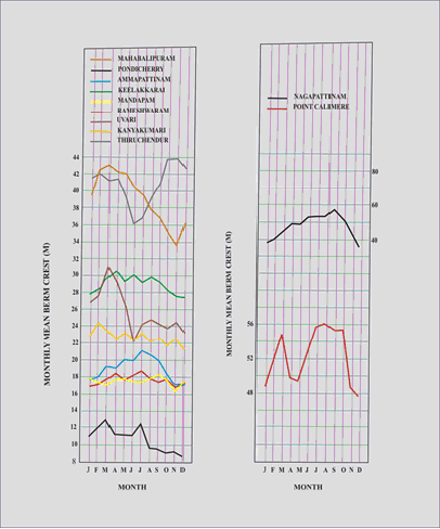
a) Annual mean berm
crest fluctuation decreases as we go from north to south from Nagapattinam to
Rameshwaram from 20 meters to 2 meters.
b) Accretion is high
always in the period between June and August. It is low (or say erosion is
high) in the period between November and January (Here Mandapam is an exception
as there is accretion in January). There
* Berm is a large reservoir of loose dry sediments making
up the beach above the high-tide line. Berm crest is an elevated ridge in the
berm, the above shore sand reservoir on the beach. (Keith Stowe, ‘Essentials of
Ocean Science’).
is a deviation from
this trend in April in Point Calimere, where there is a sudden decrease in
accretion (or an increase in erosion) in the month of April.
This data indicates
to us that the southern portion of Palk Bay is accretionary though out the year
where as the northern portion experiences both erosion and accretion.
Accretionary tendency is greater during the South West Monsoon period (June to
August) and it is low (or erosion is high) during the North East Monsoon
(October to January).
4.3.7. Beach Ridges,
Terraces and Coral Reefs at Pamban and Rameshwaram Island
‘Raised reefs are
indicators of geological changes and sea-level variations in several parts of
the globe. Walther (1991) reported on the raised reef along Rameshwaram Island
which he could not study in detail. A well preserved raised reef at Mararcadu
Point at the east of Pamban pass in Rameshwaram Island existed until two
decades ago. The elevation was 1 to 1.5 meters from the present MSL. Stoddart
and Pillai (1972) studied this in detail (This reef is also not in existence at
present). The morphology was described and the faunal assemblage listed. 14C
assay of a sample of Porietes from this reef yielded a value of 4020+
160 years B.P. This clearly indicated a mid Holocene uplift either due to
eustasim or local tectonism.’ (C.S.Gopinatha Pillai, ‘Scleractinian
Fauna’ in ‘Biodiversity of gulf of Mannar Marine Biosphere reserve’, MSSRF
Proceedings, Feb., 10-11, 1998, p-110).
‘The terraces in
Pamban area are composed of 5 small beds, each averaging 0.5 to 1.5 meters with
alternate fossiliferous bed. When these beds are extended to other areas of the
island, a thick coralline terrace, almost in continuity with those beds, has
been noticed in the village near Ariyangundu. These corals are noticed to
extend even in the low tide regions with varying height of 1.5 to 3 meters…
Around Rameshwaram
Island, mainly
Northeast of Pamban, large numbers of coral stags is recorded. The nature
of their presence with the formation of sharp pinnacles and debris around them,
suggests the possible resultant effects of regression of sea level and the
subsequent denudational processes probably, in the surf zone.
The age determination
by means of 14C method for the five samples are found to be varying
from 5440 + 60 years B.P. to 140 + 45 years B.P. Jinadasa (1988
& 1989) has also reported similar aged coastal sediments fro the western
coast of Sri Lanka.
The uppermost terrace
in Ariyangundu in the Rameshwaram Island gives an age of 5440 + 60 yrs.
B.P., while the next terrace at about 10 cm below the previous sample level
indicates an age of 3920 + 160 yrs.B.P. The upper terrace located at
Mandapam shows an age of 3670 + 65 yrs.B.P. and just 20 cm below that
one gives an age of 2630 yrs. B.P.
A coral sample which seems to be recent,
occur in the level of MSL at the east of Ramakrishnapuram near Rameshwaram
shows an age of 140 + 45 yrs.B.P. The coastal terrace found in
Rameshwaram Island has shown that the coral growth has been initiated around
that period in that island and continue to emerge or withdrawal of sea level
might have caused the second terrace around the years of 3920 + 160 yrs.
B.P. in the island. The other terraces younger in nature in the island
must have been available in the same place because of the continuity of coral
existence even today in the low tide region, probably, much in deeper portions.
At the same time, the corals, very closely placed and just opposite to the
island, indicate an age of 3650 yrs.B.P. as the upper most limit. This may be
interpreted as the period of first coral growth initiated in the Mandapam
beach. The period earlier than that might not have been suitable for coral
growth in that region or the area must have been submerged to encourage
nearshore coral growth. Since that period, coral growth must have flourished
both in the island and in the mainland areas.
When the landsat
imagery has been scrutinized, the corals which have shown 5440 yrs. B.P. at
Aryangundu is found to be in distinct horizons within the island, making
perhaps an older coral zone. Thankachimadam and Mandapam region display similar
spectral signatures, but differing from the earlier one, noticed at
Aryangundu. It is considered to be of
younger in nature. From the existing data, it is inferred that there was a
coral island existing even before the formation of Mandapam ridges. From that,
Rameshwaram patch, Aryangundu area must have been developed later than 5000
years and subsequently, the Pamban extensions. During the period earlier to
5000 years, the channel between mainland and Rameshwaram must have been
somewhat deeper or the Vaigai river must have debouched the sediments in
thechannel and made the channel unworthy for coral growth.” (G.Victor
Rajamanickam, V.J.Loveson, ‘ Results of radiocarbon dating from some beach
terraces around Rameshwaram Island, tamil Nadu’ in G.Victor Rajamanickam ed.,
‘Sea Level Variation and its impact on coastal environment’, Tamil University,
Thanjavur, 1990)
4.3.8. Devipattinam –
Kilakkarai Beach Ridges
‘The coastal zone
between Devipattinam to Kilakkarai, define interesting piece of land furnished
with peculiar arrangement of beach ridges, This sharp, triangular strip of land
might have been drawn the support of tectonic activity mainly caused by Vaigai
fault system during the course of its development. The coastal area lying north
side of Vaigai river is comparatively having 2 to 3 series of beach ridges
whereas the southern side is furnished with 6 to 7 series of beach ridges. It
may be suggested that area of southern side of Vaigai River is attended by
intensive marine action and deposition compared to northern area. The beach
ridges along southern part of Vaigai river are curvilinear and showing complex
pattern of arrangements of beach ridges extending from Mandapam point to
Kilakkarai. While studying the cross profile between Ramanathapuram and
Periyapattinam coast, the displacement of beach ridges shows the same
arrangement pattern around the present day Coleroon river. By comparing this,
one can suggest that once Vaigai might have been flowing along Ramanathapuram
to Periyapattinam coast. This is also confirmed by the bathymetric study around
Periyapattinam offshore area (Loveson & Rajamanickam, 1989).’ (V.J.Loveson, G.Victor
Rajamanickam, K.Anbarasu, ‘Remote sensing application in the study of sea level
variation along the Tamil Nadu coast, India’ in G.Victor Rajamanickam ed.,
‘Sea Level Variation and its impact on coastal environment’, Tamil University,
Thanjavur, 1990, p- 187-188)