Guiengola Archaeological Zone |
| Trail Data Length each way = 4.2 km. Exertion index = 400 going 62 returning. Maximum elevation = 448 m. |
|
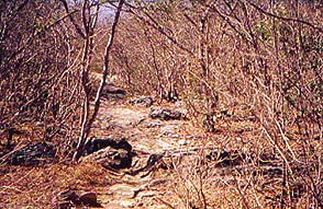
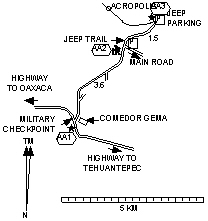
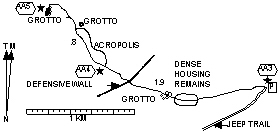
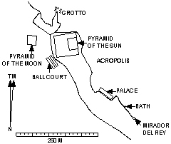
The Zapotecs built Guiengola after they left Monte Albán. During the 15th Century they fortified it against the Aztecs but the Aztecs defeated 60 000 Zapotecs and Mixtecs there anyway. Sometimes visitors to Mexico will express a desire to see archaeological sites that haven't been stabilized and rebuilt. Usually sites like that are just piles of rubble but Guiengola is actually in pretty good shape although only minimally stabilized. Much of the plaster used to cover the stone structures is still in place. The statistics for the hike assume you go from the dirt road up the jeep trail and follow the foot trail to the ceremonial site and beyond that to the northern of the grottos. Of course you can spend some more time looking around in the ruins. Obviously you'll be careful not to disturb the stone structures. Although the hike isn't long or strenuous the temperature can be high. Mornings are better of course but take some water along whatever time you go. There's a lot of sharp brush to go through so long pants are a good idea. Thanks to the Mexican Army finding the trailhead is easy. The Army has a checkpoint at Km 239.7 about 20 miles or 32 km from Tehuantepec on the highway toward Oaxaca. You just need to go NE on the dirt road that leads away from the checkpoint. In 2.2 mi (3.6 km) where the road bends to the right you'll reach the jeep trail on the left. |
|