 Paricutín is a volcanic mountain that was active in the last 60 years.
There now are two things to see: a church that was partially buried in
lava and the mountain with its crater.
Paricutín is a volcanic mountain that was active in the last 60 years.
There now are two things to see: a church that was partially buried in
lava and the mountain with its crater.
The church is easy to get to: a short hike down a dusty trail and a short scramble over lava rocks.
The mountain is more of a challenge. The easiest way is to reach it is to rent a horse from one of the many horse wranglers; the cheapest place to rent seems to be at the food stalls near the church.
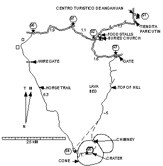 If
you're going on foot
the easiest way is to follow the horse trail
around the lava bed
although much of the trail is soft volcanic sand.
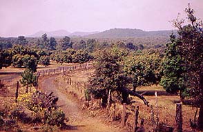
Most of the scenery looks desolate
with shrubs and small trees growing
as well as they can in the volcanic sand
but part of the trail goes
through farm country with some impressive orchards.
If
you're going on foot
the easiest way is to follow the horse trail
around the lava bed
although much of the trail is soft volcanic sand.
Most of the scenery looks desolate
with shrubs and small trees growing
as well as they can in the volcanic sand
but part of the trail goes
through farm country with some impressive orchards.
The other way is to pick your way over the lava bed. Local young people do it for fun and it is a little faster but the bed is very rough and full of crevices so that with scrambling and backtracking it requires quite a bit of effort. The surveyor despaired of mapping a trail through it. If you go this way look for places where the rocks have been broken up by foot traffic and for white marks that have been painted on the rocks. Those trails such as they are lead to a chimney formed by the main volcanic cone and a daughter cone on its northeast side. There are several trails going up the cone all of them very steep and that's one of the two main ones.
The other main trail up is on the west side of the main cone where the horse trail ends. None of the trails up rates a single star but the footing in the volcanic cinders on this trail is a little less loose than on the others. So even if you go through the lava bed the recommendation here is that you work your way over to the west side. It will be amply challenging.
The following instructions for reaching the trailhead are an abridged version of those given in Church and Church Traveler's Guide to Mexican Camping (Rolling Homes Press):
Starting at the turnoff from MEX 37 Highway near Km 59 8 miles (13 km) north of Uruapan Michoacán go west 11.9 mi (19.2 km) and turn left on a paved road near the outskirts of Angahuan. Proceed .8 mi (1.3 km) .1 mi past the town square and go left again. The house on the forward corner there has a big satellite dish on its roof. In another .6 mi (1 km) you'll reach the Centro Turístico de Angahuan. You can park there or at the restaurant just before it or at the Tiendita Paricutín just beyond it. The trail begins at the entrance to the Centro Turístico and goes to the right of it.