Oteviachi |
|
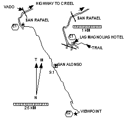
Length each way = 9.1 km. Exertion index = 235 going 365 returning. Maximum elevation = 2271 m.
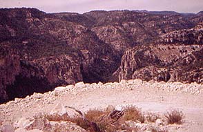
This hike takes you over some volcanic rock formations and into a farming valley where you'll pass the little church of San Alonso and the littler school next to it. Then you'll go along a knife-edge ridge between two valleys to a viewpoint of canyons with toe-curling verticality. To get there from Creel go south to the Divisadero intersection and go right. Follow the highway all the way to San Rafael. At Km 55.3 you reach the end of the pavement. Soon after that you go over a vado and then get back on pavement. Just before the road goes over some RR tracks go left at a tee and then make a quick right. In a short block you'll see comfortable-looking Hotel Las Magnolias on the left. Park next to it so it'll look like you're inside on business. Just to the right of the hotel is the jeep trail to Hostal Oteviachi. Just follow the jeep trail no tricks no turns. |
|