Cuarenta Casas |
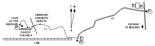
Cuarenta Casas has cliff dwellings like those in the Four Corners area of the US. To see the dwellings involves hiking down and up the sides of Arroyo Garabato, a small pretty canyon on stair-stepped switchbacks.
To get there go through Madera on the main street Calle 3a. Continue north on the highway for 43 kilometers to Km 43 and turn left. Follow the poor dirt road .8 mi (1.3 km) to the parking lot.
The closest accommodations are back in the direction of Madera at Hostales Paraíso Madera Peñitas. They have rustic but clean cabins and a campground with restrooms and hot showers for tents or RVs. At Km 8.4 turn east at a sign for Presa Peñitas. Cross a cattle guard, go .9 mi (1.4 km) to another cattle guard and another .3 mi (.5 km) on a compacted road to the entrance.