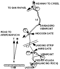
Divisadero |
|
Length each way= 1.7 km. Exertion index = 70 going 75 returning. Maximum elevation = 2403 m.
This short easy hike with canyon views is a good add-on to the Oteviachi hike since there's not much extra driving involved. From San Rafael go back 11 km to the Divisadero turnoff. Go past the Posada Barranca Hotel .7 km to where you can see a wooden entrance gate 20 meters to the left of the road. That's the trail head. Follow the jeep trail except that sometimes there is a foot trail nearer the rim. You'll come to the viewing point for the balancing rock which is slightly to your left. You can climb onto the rock if you wish and feel it wobble and probably slide a little toward the precipice. Really it's for indecisive suicides. Some 300 meters further along the rim is a ladder made by locals to access the trails below. If you feel confident enough in the ladder you can go down and ramble about the sparsely-populated hillsides. |
|