Cusárare |
|
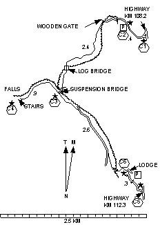
Km. 108.2 to suspension bridge: Distance = 2.6 km. Exertion index = 45 going 100 returning. Maximum elevation = 2245 m.
Km. 112.3 to suspension bridge: Distance = 2.9 km. Exertion index = 20 going 40 returning.
Suspension bridge to falls: Distance = .9 km. Exertion index = 50 going 95 returning
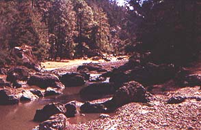
There are two trails to the cascades. Both are equally beautiful following streams through wooded canyons to a waterfall. The Raramuchi access (Km 108.2) is recommended because the access is much easier and safer. But there's nothing to keep you from hiking up the other way for extra distance before returning to your car. The toll for either is about 20 pesos per person. Km 112.3 Access. On the right from Creel. There's a sharp dropoff at the entrance and it's tough getting back on the highway because you can't see traffic. You have to park near the highway unsupervised or drive down a treacherous road to the gate. There is a rustic lodge where you can stay for a change from the hustle and bustle of Creel. Km 108.2 Access (Raramuchi). Better/safer exit than at Km 112.3. Follow the rough road .4 mi (.6 km) to a store/cafeteria to park. If the road is dry go on another .1 mi (.2 km) to the gate. |
|