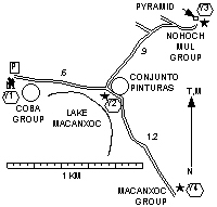
Cobá Archaeological Zone |
|
Length of round-trip = 5.4 km. Exertion index = 0. Maximum elevation = 103 m.
 Bikes are okay. It's hardly worth taking them off the rack
though
and
there are mandatory bike parking places that aren't secure. You can
rent a single-speed clunker for under US$3 (pay in pesos).
Bikes are okay. It's hardly worth taking them off the rack
though
and
there are mandatory bike parking places that aren't secure. You can
rent a single-speed clunker for under US$3 (pay in pesos).
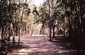
The archaeological zone at Cobá doesn't have stunning temples. Instead the remains are of poor construction and are poorly preserved. On the other hand it's the best hike on the Yucatan Peninsula. Admittedly it isn't very long but it offers natural jungle vegetation freedom from motor traffic and some things to see. A bike would defeat the purpose of the trip. For our purposes the trail head is the entrance to the zone and the destinations are the Nohuch Mul pyramid and the stelae at Macanxoc. The stelae are good examples of that classic-Maya art form.
 The trails are
essentially flat. Note that the trails mostly follow ancient Maya
elevated roads so the hiker is spared what little unevenness the
terrain has. You'll see that most clearly on the way to Macanxoc.
The trails are
essentially flat. Note that the trails mostly follow ancient Maya
elevated roads so the hiker is spared what little unevenness the
terrain has. You'll see that most clearly on the way to Macanxoc.
Consequently the exertion index is approximately zero. You can raise that by climbing some of the pyramids. Nohuch Mul is the tallest at 42 meters.
If you're in a group to share the cost hiring a guide will make the visit more interesting. All the guides have to pass a test so they know pretty well what there is to know. Be aware that next to nothing remains of prehispanic Maya writing and the site was abandoned centuries before the Spaniards arrived. If you ask a question about history or lifestyle the guide probably will make something up.