Balcón de Montezuma |
|
Length of round-trip circuit = 3.9 km. Exertion index = 80 going 290 returning. Maximum elevation = 1259 m.
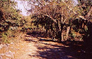 The ridge between Altas Cumbres Village and the simple ruined
settlement known grandly as Balcón de Montezuma shows a rich
concentration of dryland plants including cactuses
agaves and desert
palms
along with drought-tolerant deciduous trees.
The ridge between Altas Cumbres Village and the simple ruined
settlement known grandly as Balcón de Montezuma shows a rich
concentration of dryland plants including cactuses
agaves and desert
palms
along with drought-tolerant deciduous trees.
The ruins amount to some circular house mounds and some farming terraces that look to have been formed naturally and improved by moving some rocks around. It was occupied from 200 BC to the 16th Century.
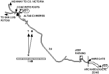 The
turnoff to Altas Cumbres is at Km 154 on the old highway from Cd.
Victoria to San Luis Potosí. The highway leaves Cd. Victoria from the
SW end of town
and is called Calzada General Luis Caballero in the
city.
The
turnoff to Altas Cumbres is at Km 154 on the old highway from Cd.
Victoria to San Luis Potosí. The highway leaves Cd. Victoria from the
SW end of town
and is called Calzada General Luis Caballero in the
city.
If you go from Cd. Victoria the turnoff is to the left at a blind curve. To avoid the awkwardness of a head-on collision go on another .3 mi (.5 km) to a wide spot where a small car or truck could turn around or .9 mi (1.4 km) to a better turnaround.