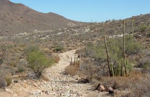
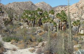
The trail to the Santa María Mission crosses rugged terrain
to an unlikely oasis in the midst of stony desert. All that's
left of the mission are some badly eroded walls of the mission
church. But the stand of palm trees in a little swamp is still
there
flourishing. Follow the stream as far as you like.
Temperatures can reach over 100°F
so summer isn't a good
time of year.
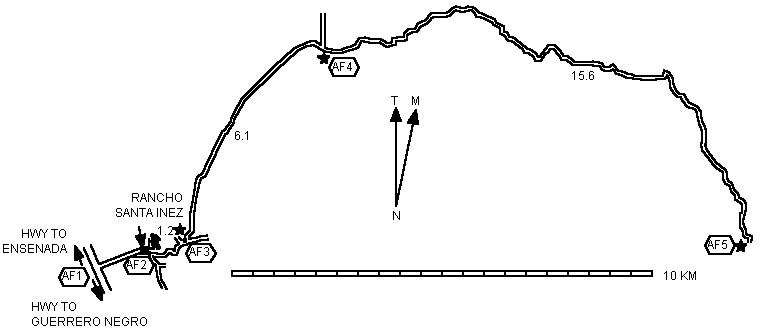
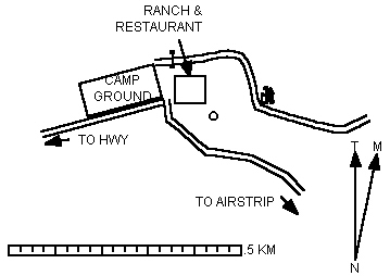
The trailhead is at the Santa Inez Ranch. You can park
there for a small fee. You also can camp; the facilities are
modest but it's cheap. And there's a restaurant; if it's not
open you'll have to go into the nearby town.
When you start out
be sure to tell someone at the ranch
about your plans. If you're overdue they may be able to send
out a rescue party. Alternatively
if you're going to be out
overnight they need to know not to send one.
To start
go around the ranch buildings from the NE corner of the
camping area. If the gate is locked then you have to go around to the
other side of the ranch buildings and go through the gate into
the livestock yard.
Early in the hike there are two side-trails leading to
private residences. Once you're past those
the trail is distinct and
easy to follow
thanks to ATVers who motor their way up. It's
not actually a good ATV trail
because there are patches of
loose stones and some very steep parts. But it's an excellent
hike
with great
even dramatic
scenery.
Locals claim that water is always available near the
mission. If you intend to replenish your water there
be sure
to treat it
even it it's running and clear.
|