
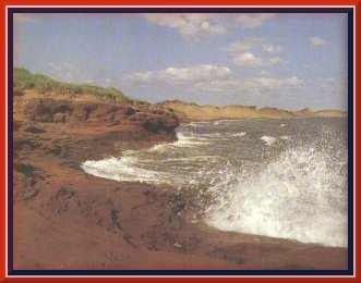
 Prince
Edward National Park is on the north shore of the island, a tiny crescent
set in sparkling waters on Canada's massive tapestry. its 1609 kilometres
(1000 miles) of pink sandy beaches frame the red sandy loam. This rich
earth ensures the success of the patchwork of farms. The Indians called
the island Abegweit, meaning "cradled in the waves", and it is thought
that they cultivated the land for untold summers before their world was
shattered. On his first voyage in 1534, Jacques Cartier described the island
as "the fairest one could possibly see" and ". . . full of pease, white
and red gooseberries, strawberries, raspberries and wild wheat like rye,
which looks as if it had been sowed and cultivated".
Prince
Edward National Park is on the north shore of the island, a tiny crescent
set in sparkling waters on Canada's massive tapestry. its 1609 kilometres
(1000 miles) of pink sandy beaches frame the red sandy loam. This rich
earth ensures the success of the patchwork of farms. The Indians called
the island Abegweit, meaning "cradled in the waves", and it is thought
that they cultivated the land for untold summers before their world was
shattered. On his first voyage in 1534, Jacques Cartier described the island
as "the fairest one could possibly see" and ". . . full of pease, white
and red gooseberries, strawberries, raspberries and wild wheat like rye,
which looks as if it had been sowed and cultivated".
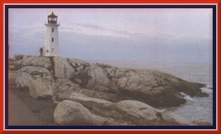 Massive
rocks and a prim but sturdy lighthouse near Woods Island in the south-east
of Prince Edward Island watch over the land when the sea threatens. Two
ferries crossed Northumberland Strait, one between Woods Island and
Caribou, Nova Scotia, and the other between Borden and Cape Tormentine,
New Brunswick -- comforting links with the mainland. The Confederation
Bridge, opened on May 31, 1997 joins Borden-Carleton, Prince Edward Island
and Cape Jourimain, New Brunswick. At 12 .9 kilometre long, it is the longest
bridge over ice covered waters in the world.
Massive
rocks and a prim but sturdy lighthouse near Woods Island in the south-east
of Prince Edward Island watch over the land when the sea threatens. Two
ferries crossed Northumberland Strait, one between Woods Island and
Caribou, Nova Scotia, and the other between Borden and Cape Tormentine,
New Brunswick -- comforting links with the mainland. The Confederation
Bridge, opened on May 31, 1997 joins Borden-Carleton, Prince Edward Island
and Cape Jourimain, New Brunswick. At 12 .9 kilometre long, it is the longest
bridge over ice covered waters in the world.
Back to CANADA
index
![]()
![]()
![]()