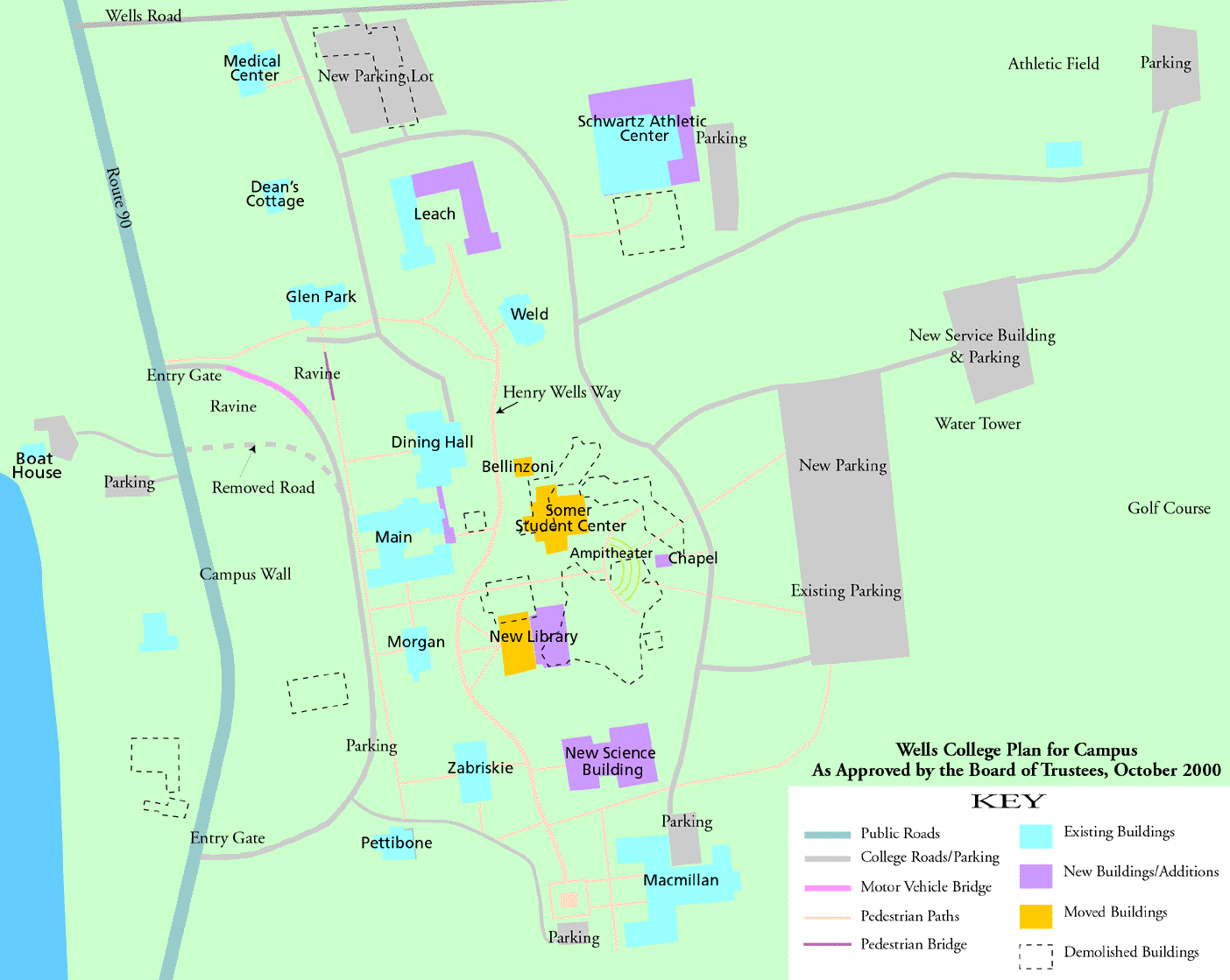
A large aerial-view painting of the master plan lay-out was on display in Macmillan for over a year (until it was removed for Reunion 2002). This map was much easier to understand than the scale model previously displayed (and featured on the cover of the Spring 2001 Express), as it had labels and outlines of destroyed or moved buildings. The plan showed:
1. Barler Music Building (1974), which houses all the instructional facilities for music (recital hall, rehearsal space, practice rooms, listening lab, choir library, history and theory classrooms, piano lab, teaching studios, offices, and seminar room), is destroyed. Its functions are replaced by no other structure.
2. Campbell Art Studio (1974), housing all facilities for the applied fine arts (painting and drawing studios, ceramics studio, dark room, instructional space, faculty offices), is destroyed. Its functions are replaced by no other building.
3. The award-winning Louis J. Long Library (1968) is destroyed, all 55,000 sq. ft. of it. A "new" library is shown as the re-located and expanded Cleveland Building (1909), which now houses Foreign Languages and Literature. Before 1968, Cleveland used to be the Wells library; it was thought to be inadequate by 1960. (Even with the planned expansion, it looks way too small.) It will be positioned roughly where Smith is now.
4. Cleveland's new location overlaps part of the present location of Long Library. Therefore, the current library will have to be destroyed before the new one can be moved into place. (No plan is indicated for the temporary housing of the library collection while this takes place.)
5. No housing is shown for the Foreign Languages and Literature instructional facilities (language lab, film/lecture hall, classrooms, offices for German, French, Spanish, and Italian) which will be lost when Cleveland reverts to being a library.
6. Smith Building (1905), renovated and expanded in the late 1990s to become the Sommer Center (snack bar, social hall) is moved and expanded again into an even larger student center.
7. The oldest building on campus (1879), now called the Bellinzoni Building, is also be moved.
8. Dodge Dormitory (1967) is shown destroyed and replaced by a parking lot. Leach Dormitory (1960) is mored than doubled in size, becoming a large U shaped building, with the opening facing south.
9. A new central walk called Henry Wells Way cuts through the campus, north-south, from the U of the new Leach, behind Main, to the front of Macmillan.
10. At the southern end of the walk, in front of Macmillan, is a block with the label �Wells Stage Coach.� It is unclear whether this is some sort of monument or statue.
11. There is a large outdoor amphitheater and a very small new chapel shown where part of the Music Building used to stand.
12. The athletic facilities housed in the old Student Union (1957), later expanded and renovated as the Schwartz Center (1988), appear to be partly destroyed and partly expanded.
13. New gated entries are indicated for the redesigned semi-circle driveway in front of Main.
14. A new bridge for car traffic is shown built across the Glen Park ravine just to the west (the lake side) of the GP bridge. The drive then links up with the semi-circular drive in front of Main.
15. A wall is built running N-S all along the western edge of the campus lawn.
16. The new science building is shown in what is now the MacMillan parking lot.
17. Zabriskie (1905), the present science building, remains unchanged, though as the only available space it may be expected to house any surviving foreign languages, plus whatever is allowed to remain of the art and music programs, and perhaps the transitional library.
18. The maintenance building and garage on Route 90 are destroyed. New ones are placed far up the hill, in the woods and hidden from view. Attractive, but impossible to reach in order to get the plows after a big snowstorm.
Wells Students have voted their campus one of the most beautiful in the country year after year in the Princeton Review. Why should it be radically redesigned? How beautiful will it be while all this is going on? Imagine living in Main while buildings are being moved, roadways built, major structures destroyed. Imagine using a "temporary" library for most of your undergaraduate career. Imagine what impact implementation of the Master Plan will have on student recruitment and retention.
________________
Top of Page
Diagram of the Master Plan map, showing demolition, moved structures, and expanded buildings.
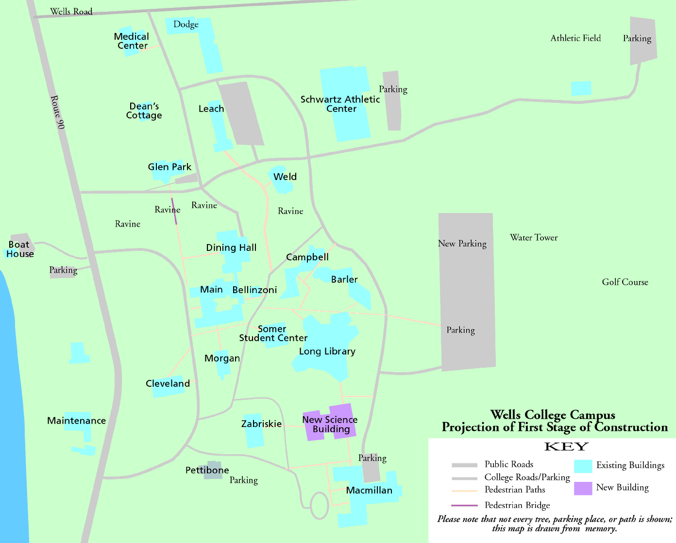
Layout of the present campus, with the addition of the proposed new science building.
Return HOME