| SEINE RIVER INTERPRETIVE TRAIL |
 |
| A Feasibility and Design Study of an Interpretive Nature Trail along the Seine River between Provencher Blvd. and Marion St. as prepared by the S.O.S River Environment Trail Committee. Preservation, Restoration and Appreciation of the Seine River |
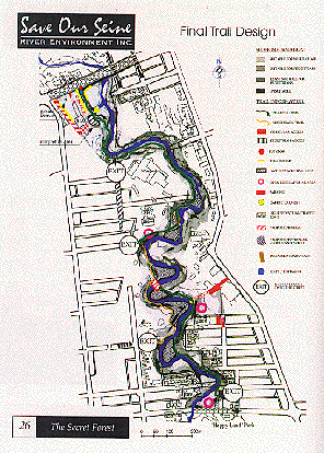
| During the summer of 1995, S.O.S. commissioned a study on the feasibility of creating a low impact interpretive nature trail along the banks of the Seine River between Provencher Boulevard and Marion Street. Two students from the University of Manitoba, Jared Whelan-Enns from the Faculty of Science, Environmental Science Program and Larissa Panachenko from the Faculty of Architecture's Landscape Architecture program were hired to conduct the study. The two students worked under the guidance of the S.O.S. board of directors and the organization's trail committee, with support and research material also provided by members of the City of Winnipeg Seine River Task Force. The work was carried out using the facilities at the Faculty of Architecture, University of Manitoba. The eighty page report includes the goals and objectives of the trail feasibility study, the process of gathering research material, the synthesis of data collected and a detailed design proposal. A survey was conducted to obtain public opinion about the proposed trail. It also served as an initial step to involve the local residents in the planning phase of the trail project. Included in the report is a summary of the results of the survey which provided important guidance for the design of the trail and the development of recommendations for its construction. |
 |
| A system of interpretive signs or selfguiding program materials identifying areas of natural and historic significance along the trail will be established. Winnipeg's rivers and streams are now recognized by most of its residents as valuable natural, recreational and aesthetic resources which add to the quality of life in the city. The Seine River corridor is a part of this resource which, until recently and except for its role as a drainage feature, was largely ignored in the city's development plans. This lack of consideration has limited public access and placed undue stress on the river and its ecosystem. It has also allowed this "forgotten river" to retain much of its natural character. |
| GOALS AND OBJECTIVES The following goals and objectives were developed as part of the Seine River Interpretive Trail feasibility study: Goals To design and develop a year round low-impact, multi-use trail that would provide easy access for the public and special groups. To promote environmental and historical education opportunities within the context of sustainability and stewardship. Objectives To survey the residents in the adjacent community to determine their opinions of the proposed trail development. To research the physical, biological, and cultural characteristics of the riverbanks between Provencher Boulevard and Marion Street to determine the feasibility of a low impact interpretive trail. To collect available data on existing vegetation, wildlife and historical points of interest along the Seine River in the area of the proposed trail. To clarify private, city, and commercial land ownership along the proposed trail route. To ensure that any trail design proposed by the study adheres to the City of Winnipeg's sustainable development policies. Specific Objectives for the Trail Provide improved access to the Seine River in order to reveal the beauty, distinctive character and value of its riparian ecosystem. Provide access to the trail for people of various levels of physical ability. Provide a unique opportunity to observe past human use and impact on the Seine River's natural environment. Develop a trail design that would provide for multiple use. Establish a system of interpretive signs or self guiding program materials identifying areas of natural and historic significance along the trail. Restore and enhance the natural vegetation and wildlife habitat of the riverbank environment. Monitor the impacts of the trail on the environment and on private property and develop mitigation measures as part of the management plan. Respect and protect the privacy of property owners in the area of the proposed trail. Ensure the safety and security of the proposed trail route. A trail design that provides for walking and nature watching for people of various levels of physical ability. |
| SOS Web Page(1997) |