AN ANALYSIS OF ENDOR (II)

This is the illustration named The Man in the Moon, taken from
J.R.R. Tolkien: Atrist and Illustrator.
It has a comment in that volume which reads:
One can identify the British Isles, Europe, India, Africa, and
North America on the Earth;
but there are unfamiliar continents in the Atlantic and Pacific Oceans,
presumably Atlantis and Lemuria.
It is this comment that holds importance, or rather - it's assumption -
where the import exists.
*
The first neglected conclusion that has bearing is from Return of the King;
Appendix E - The F�anorian Letters
in that 'Paradise' has it's orientation
cartographically as North.
These letters commonly indicated the points W, S, E, N
even in languages that used quite different terms.
They were, in the Westlands, named in this order, beginning with and facing west;
hyarmen and formen indeed meant left-hand region and right-hand region.
The second neglected conclusion that applies is from Letters of J.R.R. Tolkien - # 294
where Professor Tolkien is discussing Middle-earth itself:
Geographically Northern is usually better.
But examination will show that even this is inapplicable
(geographically or spiritually) to 'Middle-earth'.
The third neglected conclusion that is relevant concerns the significance of the
picture itself. It is correctly related to passages in Book of Lost Tales
in the Artist and Illustrator commentary section, but the assumption of
Atlantis and Lemuria are an incorrect Mythology to relate to something already
positively identified with Middle-earth.
It's interesting that Uin; the Great Whale who led the ferrying of Tol Eress�a
across the sea to Valinor, is also present in Roverandom, which seems to utilize
this same illustration for its benefit; while making reference to the Shadowy Seas, The Bay
of Fairyland, Elvenhome, and the City of the Elves on the green hill beneath the mountains.
A last and important neglected conclusion (of those I am addressing) is found in History Volume 8;
The Treason of Isengard - The First Map of The Lord of the Rings when referring to
the map published in that Volume:
Of the various small-maps of the western regions of Middle-earth that my father made,
one is very easily seen to be the earliest of the maps that are extant,
but was in fact the first one that he made
(other than the hasty sketches of particular regions published
in Vol. VI).
HOWEVER -
Christopher also makes this remarkable statement in the same chapter:
In Unfinished Tales I referred to my father's maps of
The Lord of the Rings as 'sketch maps';
but this was an ill-chosen word, and in respect of the First Map a serious misnomer.
All parts of the First Map were made with great care and delicacy until a late stage of correction,
and it has an exceedingly 'Elvish' and archaic air.
The difficulties of interpretation do not arise from any roughness in the original execution,
but in part from subsequent alteration in very small space, and in part from its present condition:
it is wrinkled, creased, and broken from constant use, so that connections are lost,
and many names and markings added in pencil are so blurred and faint as to be almost invisible.
I shall address this exceedingly important point at the end of this analysis;
after evidence has been given.
*
All subsequent illustrations in this analysis are magnified at 600%; and are non-enhanced.
Notable exceptions to this are:
1. Removal of the gossamer moon-threads intruding upon the map.
2. Removal of the extraneous background illustration.
3. Removal of a continent for clarity.
4. A reorientation of the map that is more familiar to readers; again for clarity sake only.
5. The obvious clarity markings in the last illustrations to sum up the analysis.
All markings present are natural and not photo-edited in or created artificially in any other way.
To satisfy curiosity, a magnifying glass and\or independent seperate scan of this illustration
from any Artist and Illustrator Volume will attest to the same
markings under impartial scrutiny.
I unfortunately have no information on the original canvas size of the painting to compare details.
This illustration has the following modifications made at this time:
1. The reorientation for readers to a more recognized aspect.
2. The removal of the threads emanating from the Moon
3. The removal of the extraneous background.
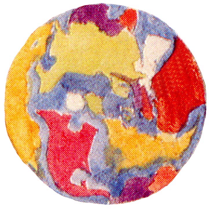
The first immediately recognizable form is what Artist and Illustrator
assumes is Lemuria - with that of Valinor.
This is the direction which would lead to Paradise in Middle-earth cartography
as stated above; taken from Appendix E.
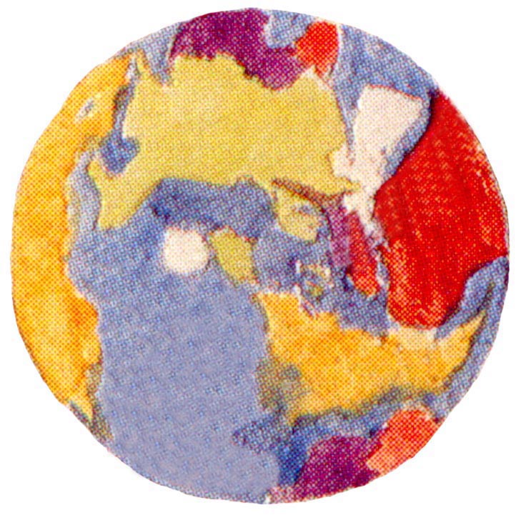 This illustration has the removal of the North American continent for clarity, as advised earlier.
 This illustration has the clarity markings inserted to draw attention to the Middle-earth
connection.
This illustration has the clarity markings inserted to draw attention to the Middle-earth
connection.
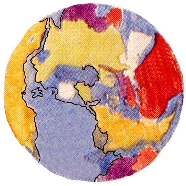
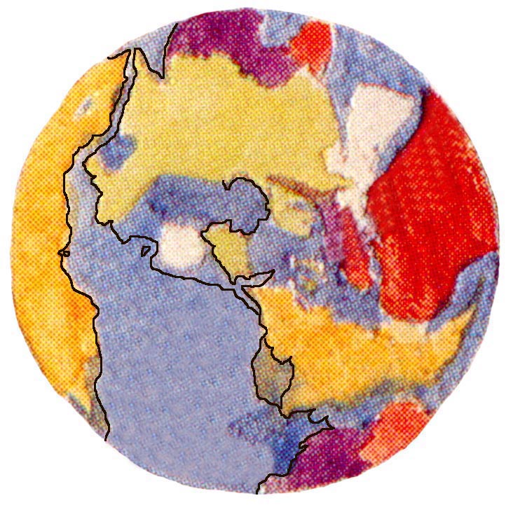
I have chosen to use what are finished lines to clearly show the relationship.
The only exception to this is with the coast of Anfalas, which now resembles the original
rounded coast drawing as shown in History Volume 8; The Treason of Isengard -
The First Lord of the Rings map.
I have also included the (to most respects) clearer view of Anfalas with the prominant
coast it has in contemporary maps.
*
From these lines many points become clear, some of which are:
1. The Shire clearly remains England.
The Palantir of Elostirion now looks directly west to Tol Eress�a.
2. The Misty Mountains are placed where they would be expected to be present in our world; namely the Alps.
They can be seen by the purple coloring to mostly take the known shape in Middle-earth.
3. Africa becomes the east where Hildorien is located.
That Africa is generally regarded as the birthplace of Mankind in our world is
probably not coincidental.
4. South America becomes Harad - as drawn on The Lord of the Rings map.
The Grey Mountains of earlier maps now closely corresponds to the Andes.
5. The Helcarax� is extremely prominant.
Also noted is the retention of the coldest areas of Middle-earth, above the line of the Iron Mountains.
6. The Sea of Okhotsk (the area just to the right of the Helcarax�) takes on new meaning.
This is interestingly placed at the location of Angband; destroyed in the War of Wrath.
7. Greenland has its place as Ossiriand.
The relation between Greenland and the Green-elves of Ossiriand is unexplored at this time.
8. What appears to be the Barrents Sea corresponds to the Bay of Forochel.
The northern extension of the peninnsula is not taken up at this time (see the summation below).
9. The Sea of Rhun (located off the West coast of Africa) takes on a good portion of its shape as seen in the LOTR map.
This sea seems to match a description later given to the Sea of Ringil -
concerning the connection between the East Sea and the Straits of the World.
This passage curiously does not match what Christopher states is appearing in:
History Volume 4; The Ambarkanta - Map 5.
I give it now:
But the symmetry of the ancient Earth was changed and broken in the first Battle of the Gods,
when Valinor went out against Utumno, which was Melko's stronghold, and Melko was chained
THEN the sea of Helcar (which was the northern Lamp) became an inland sea or great lake,
but the sea of Ringil (which was the southern lamp) became a great sea
flowing north-east and joining by straits both the Western and Eastern Seas.
This does not accord with what is clearly shown in Map IV where both
Helcar and Ringil already exist as inland seas.
10. The disappearance of Gondor, Mordor and surrounding lands takes on new meaning -
Plato's description of a drowned Continent, and no need to reconcile the mountains
with modern day Earth.
This has import in that the Mid-Atlantic Ridge could be easily equated with the White Mountains
and AFAIK there was no extensive Real-life mapping of this region at the time of the
LOTR writings that would be available to the Professor.
[More on this point in the summation below.]
*
Summation
This map apparently survived in theory at least as far as the construction
of the Quenta (c. 1930's).
I note special passages that apply to this map here:
Men fled away, such as perished not in the ruin of those days,
and long was it ere they back over the mountains to where Beleriand once had been,
and not till the tale of those days had faded to an echo seldom heard.
Christopher then remarks:
I do not know certainly what this refers to.
Related Note by Christopher:
It is also conceivable, if no more, that the meaning of the words in Q,
that it was long before Men came back over the mountains to where Beleriand once had been,
refers to the bloody invasions of England in later days described in �lfwine II;
for there is very little in that text that cannont be readily accommodated to the present passage in S. and Q,
with the picture of the fading Elves of L�thien 'leaving our Western Shores'.
But a serious difficulty with that idea lies in the coming of Men 'over the mountains'
to where Beleriand once had been.
Christopher then continues:
Unhappily the evidence for the development of the conception of the drowning of Beleriand
is extremely scanty. Later, it was only a small region (Lindon) that remained above the sea
west of the Blue Mountains; but this need not by any means yet have been the case.
Conclusion
This is possibly a reference to the crossing of the remaining Iron Mountains into North-east Russia -
and the remaing portion of Beleriand existing on Earth besides Lindon.
Christopher then continues:
It is also said in Q (again retained in Q II) that:
There was a mighty building of ships on the shores of the Western Sea,
and most upon the great isles, which in the disruption
of the Northern world were fashioned of old Beleriand.
Of the size and number of these 'great isles' we are not told.
On one of my father's sketchmaps made for The Lord of the Rings
there is the island of Himling... and also Tol Fuin...
But it seems obvious that my father was at this time imagining
far greater islands than these, since it was on them that the
great fleets were built at the end of the War of Wrath.
L�thien (> Leithien) as the land from which the Elves set sail,
named in S �18 and explained as 'Britain or England' is not named in Q;
but the words that follow in S: 'Thence they ever still from time to time set sail
leaving the world ere they fade', are clearly reflected in Q:
Yet not all returned, and some lingered many an age in the West and North,
and especially in the Western isles. Yet ever as the ages drew on and the Elf-folk
faded on the Earth, they would still set sail at eve from our Western shores;
as they still do, whern now there linger few anywhere of the lonely companies.
The relationship between these passages strongly suggests that the 'Western Isles'
were the British Isles -
At this point; Christopher interjects an opinion:
This may seem to be rendered less likely by the form of the passage
in Q II, where the first sentence is expanded:
'and especially in the western isles and the lands of Leithien.'
But I do not think this phrase need be taken too precisely,
and believe that the equation still holds.
The passage continues with:
and that England still had a place in the actual mythological geography,
as is explicitly so in S.
Conclusion
This map seems to apply still to the existing Eriol story which contains Britain
as a main part of the Mythology, as evidenced by these pre-LOTR tales.
It actually seems to explain much that is in confusion regarding the text of this time.
I note one comment from Christopher concerning the First Silmarillion Map:
It is striking that the river courses as drawn on this first map were scarcely
changed at all afterwards.
I also note in what context this is regarding:
Namely; the lands of Hithlum and Angband - and extending down until Sirion reaches the Sea.
Later the Westward extension that shows the coast and the Eastward extension showing
the Blue mountains are added.
I noted earlier that the Sea of Okhotsk had new importance.
I believe this Real World region influenced the design of the Silmarillion map
and one of the reasons this area was concentrated on first.
There was a comment earlier stated that I would later address concerning the First LOTR map.
I would like to do so now:
Professor Tolkien has the known habit of revision, extending to maps themselves.
However; Christopher has made two statements regarding the first versions of the working maps
of both the Silmarillion and LOTR maps.
These comments indicate that a 'sketch-map' of some type was present for the Professor
to create his 'first' copies from - with such uncharacteristic certainty.
Conclusion
This 'sketch-map' seems to fulfill both requirements for both working copies, as it supplies
what would be the near required coastline and general river locations for the mythology;
(and in actuality, the probable original 'outline' of coastal areas later 'copied' to the first maps)
as based on a real world connection - the original Lost Tales - and as already seen,
an integral part of the mythology.
It is my opinion that when the time came for adaptation to the newer stories, the scale of
the map was reduced to accommodate the revised stories. [See An Analysis of the First Silmarillion Map
for notes on distances].
I think that the real world connection was no longer of heavy importance - which allowed
the Professor to modify the maps slightly to 'remove it a step further from the
immediately recognizable Real World, but still retain the familiar (and long standing vision he held).
Professor Tolkien is adamant that Middle-earth is Our World; only in another time
as expressed in his letters.
I will show in:
An Anaylsis of The Hobbit map
and
An Analysis of Endor (III) (aka History Volume 4; The Ambarkanta Map V)
and
An Analysis of the First Silmarillion Map
and
An Analysis of the First LOTR Map
why I believe these maps were drawn as they were, and what significance they held in
the evolution of the mythology.
I now give the last Image in this analysis, which shows the placement of N�menor;
As explained in:
An Analysis of the Numenor Map