Satellite Exploration of Thailand > Projects

Shifting Border - Mae Sot


1973 vs. 1985


1985 vs. 1989


1989 vs. 1992


1992 vs. 2000


I was comparing the 1973 Landsat image of Mae Sot with the one taken in 1985 when I noticed that the course of the Moei River had somewhat changed during this period. I was stunned. As the Moei River forms the border demarcation between Thailand and Burma, the change in the course of the river accompanies the change of the border demarcation itself. How does the river change its course? How do the Thai Government and Burmese Government cope with it?

I found five Landsat images of the area on the internet - 1973, 1985, 1989, 1992 and 2000. When I matched them against each other, the visual effect was curious. I recognized two patterns for the change of the course of the river: gradual and abrupt. The gradual change occurs as the river erodes its banks over an extended period of time. The abrupt change is triggered by a flood during the rainy season.

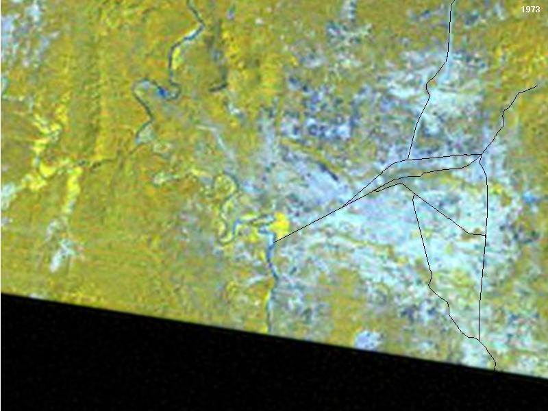
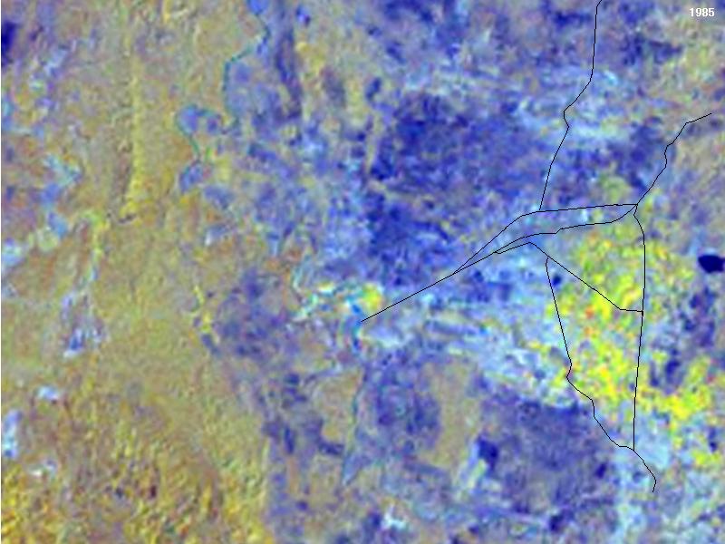
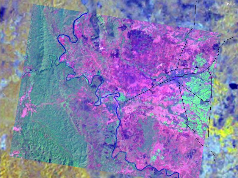
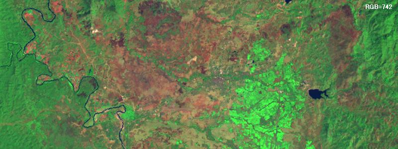
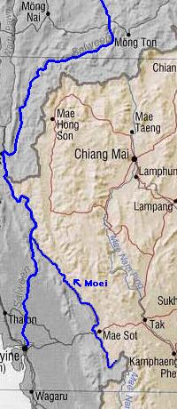
I searched on the internet on the issue of the Thai-Burmese conflict over the shifting border along the Moei River. I found numerous reports and articles. To summarize my findings,
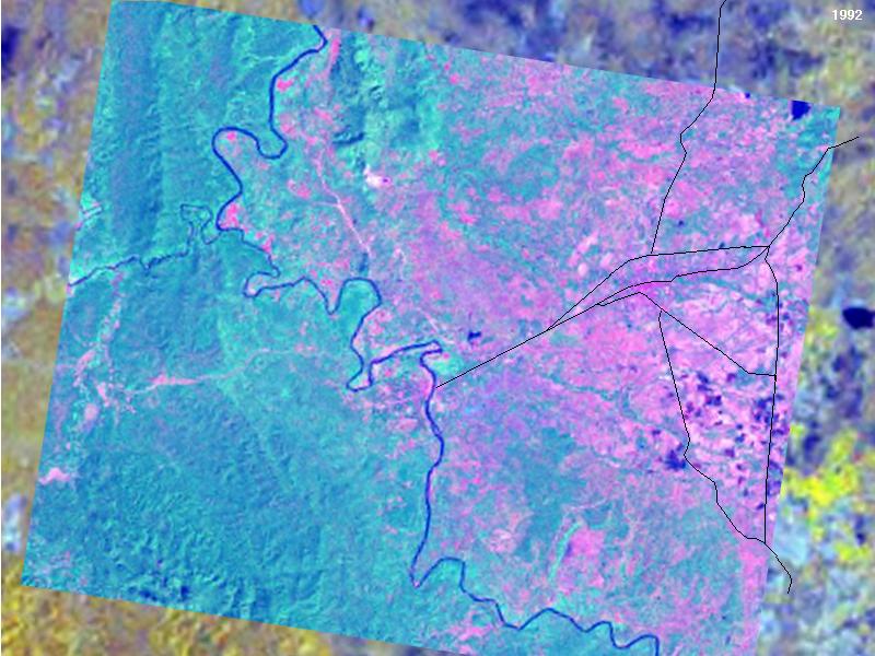
1.The border demarcation between Thailand and Burma is based on the "Convention between the Governor–General of India and the King of Siam, defining the Boundary on the Mainland between the Kingdom of Siam and the British Province of Tenasserim, 1868."
2.Whereas the border demarcation between Thailand and Laos along the Mekong River has been rather explicitly defined by a series of treaties (1894: All islands in the Mekong River belongs to Laos. 1926: The thalweg (deepest part of the river) shall be the boundary. In case of a geographical transformation, the old boundary still applies until the two Governments reach on an agreement on the border adjustment to meet geographical reality.), the 1868 Convention between Thailand and Burma is not very explicit, thus leaving a room for speculation and conflict.
3. In the lack of explicit demarcation by the 1868 Convention, the two Governments have reached on a common (but not binding) understanding that:
a.
When the border river changes its course, the border demarcation changes with the river.
b.
Islands on the river are under the sovereignty of both countries - or under the sovereignty of neither countries.
c.
When a piece of land attached to either Thailand or Burma is detatched from the mainland by a change of the course of the river, thereby becoming an island in the river, above mentioned rule-b immediately applies.
d.
Neither Thailand or Burma shall dig a canal which would alter the border demarcation. Likewise, neither Thailand or Burma shall build any constructions which may induce any change on the course of the river.
4.Whereas the demarcating section of the Salween River valley (130km) is narrow and constricted by high mountain ridges, the demarcating Moei River valley (386km) is wide and gently sloped, thus more vulnerable to geographical transformation by floods.

One way to prevent riverbank erosion is to build concrete dykes. Simple as it seems, the matter is complicated. Building a concrete dyke only on one side of the river affects the erosion on the other side, thus almost always induces protests from the other Government. Building a concrete dyke prevents loss of territory, but it also prevents (re-) gain of territory, so when and where to build one is a difficult decision. Sometimes, the very act of building a concrete dyke causes land erosion on its side of the riverbank, in which case the construction is immediately halted.

The Interior Ministry of Thailand, in 1983, drafted a master plan to built a 100km concrete dyke from Sop Moei to Phop Phra. So far, about 50% of the stretch have been completed.


Bangkok Post Articles on the Moei River Conflicts
(Searchable on the internet)
1994
Aug 20Burmese Issue Warning on Islet
Sep 12Thailand, Burma dispute islet formed by overflowing river
1995
Jan 20Vijit Warns Against Trespassing
Nov 14Thailand to Dismantle Moei River Causeway
1996
Jan 16Residents Deplore 'Hasty' Removal of Causeway
Mar 31Burma Agrees to Demolish Illegal Bridge
Apr 4Moei channels and new stalls to be examined
Apr 5Rangoon to join talks to mark border along the Moei River
May 3Thailand hopes to get Moei bridge project on right track
May 25Aerial surveys cloud bid to agree on boundaries
Jun 2Serious river erosion blamed on Burma
Jun 16Officials inspect Moei River bank in Mae Sot
Jun 27Burmese vendors shifted from islet in Moei
Jul 16Govt plans Moei embankment
Nov 8Burma restates demand
Dec 1Border river embankment construction yet to resume
Dec 20Delay in building embankment
Dec 29B50m Moei River project suspended
1997
Feb 2Chettha set to thrash out problems
Feb 26Agreement reached to end row first
Mar 4Army chief optimistic about talks
Mar 5Committee holds talks on Moei River encroachment
Mar 9Chettha: River demarcation row has yet to be resolved
Mar 30Aerial map urged to end border row
Apr 10Burmese advocate river posts for clarity
May 11New dispute over Moei River border
May 24Burmese troops in bid to change water course
May 25Protest note sent over Burma's act
May 26Burma calls off dredging of river
May 27Chettha orders troops to exercise restraint
May 28'Permission obtained' to dredge river
May 30Border confusion settled
Jun 1Chettha urges talks to avoid border row
Jun 3Burma refuses to back down in border dispute
Jun 3Claiming major flood changed river course
Jun 4PM wants mid-river border with Burma
Jun 6Row over Moei River remains unsettled
Jun 7Army chief denies giving in to Burma
Jun 11Thai-Burma talks deadlocked
Jun 13Panel to look into Burma's allegations
Jun 18Deputy FM to inspect disputed area in Tak
Jun 30Boundary talks test Rangoon's regional resolve
Jul 8Panel agrees to Burmese sector plan
Jul 15Burmese building observation tower
Jul 17100m baht set aside for river barrier
Aug 8Thailand, Burma mark border line
Oct 1Burma troops stake claim to disputed island in Tak
Oct 4Premier urged to clarify position
Oct 6Villagers to seek official demarcation
Nov 2Construction work by Burmese causes erosion
Dec 14Minister in push to settle river dispute
1998
Jan 11
River wrangle rages on
Jan 11Moei: The ever shifting river
Jan 20Burmese troops seize disputed river islet
Jan 20Where they plan to build embankment
Jan 23Burma set to pull forces off islet
Jan 24Burmese troops say sorry to Thais for seizing islet
Feb 1Thai troops set to fight if Burmese invade island
Feb 2Troops to leave disputed islands
Feb 8Burma still continuing dam work
Mar 20Rangoon resumes dyke building
Apr 9Efforts to map out Burmese border begin to take shape
Jun 5Senate panel studies disputes
Jun 21Burma says 'no' to joint committee meeting
1999
Mar 7Burma dyke encroaches on Thai soil
Mar 14Burma continues violation of demarcation agreement
Mar 7Burma dyke encroaches on Thai soil
Apr 8Pressure to reinforce river wall
Apr 11Tak calls for protest on river wall
2001
Jan 20River island dispute settled
Feb 14Protest over Mae Sot dyke
January 11, 1998

BORDER DISPUTE

River wrangle rages on

Thai-Burmese border problems in Tak were in the news again last month when Deputy Foreign Minister Sukhumbhand Paribatra inspected a disputed area in the Moei River in Mae Sot district. Here, we look at the root causes of the problems.

SUPAMART KASEM
Mae Sot, Tak

Man's interference with nature started the Thai-Burmese border conflict in the Moei River, but failure to strike a sound solution has contributed to a worsening of relations.

The dispute has escalated to a confrontation since a deluge in July 1994 changed the course of the Moei River and cut off Burmese land opposite Mae Sot district. Siltation has since created a 150-rai area connected to Thai territory.

Burma still claims the land near Wat Phrathat Khok Chang Pheuak in Baan Mae Tao, Tambon Tha Sai Luad, while Thailand contends the new course calls for readjustment of the demarcation.

The Moei River was defined as a border line between Siam and Burma under a convention signed on February 8, 1868 between the King of Siam and the Governor-General of India under British colonialism.

The conflict could have been averted had both sides not interfered with nature, according to a former ambassador, who said the river's natural course that changes every year made both sides stand to gain and lose. Traditionally, when islets created by the current connected to Burmese soil, the locals exploited the area and vice versa.

He said that the crux of the problem is that both sides concentrated too much on protecting their interests. In order to keep their territories intact, Burmese and Thai authorities built embankments and barriers to prevent soil erosion.

Burma's driving of stakes and building of concrete walls along certain stretches of the river to divert the current caused massive land erosion on the Thai side. In response, Thai authorities built embankments.

The Thai-Burmese Technical Committee has engaged in several rounds of talks over the definition of the border line between Mae Sot and Myawaddy in the Karen State of Burma, but a settlement has yet to be reached.

The 1868 agreement stated that "the eastern side of the river belongs to Thailand, and the western side belongs to Britain. Both sides have joint sovereignty over river islets."

In the case of the Khok Chang Phueak dispute, Thai people understand that the silted-up area should become part of Thai territory under the 1868 agreement. But Rangoon has insisted on claiming the land. The dispute escalated in May last year when Burma sent troops to dredge a section of the silted-up area to change the water course back to its original position to reclaim land they say was lost after the floods.

Thai authorities, however, claimed that Burmese troops did not dredge the original course but tried to enlarge the disputed area by intruding 200 metres into Thai territory.

Somboon Sa-ngiambutr, director-general of the Foreign Ministry's Treaties and Legal Affairs Department and head of the Thai team in the joint technical committee, said international law allows Burma to reclaim the lost land at Khok Chang Phueak. According to the law, if there is a sudden change in the river course, the original owner retains the right over the territory.

The silted-up area protruding from the Thai side should belong to Thailand, he said. This has always been a basic principle for bilateral talks over border rows, he added.

Start of confrontation: Myawaddy authorities first hired a Thai company to dredge the disputed area on May 13 last year. Thailand protested, saying the dredgers had intruded 200 metres into Thai territory. The Myawaddy authorities then ordered a temporary suspension of the work, only to resume it later that month.

Col Chachatpat Yamngarmriab, chairman of the Thai joint border committee, sent a memo to his Burmese counterpart, Lt Col Saing Phone in Myawaddy asking Burma to suspend the operation until a settlement was reached. But Burma ignored the request and sent an extra 200 troops to the disputed area.

On the following day, Maj-Gen Chalor Thongsala, commander of the 4th Infantry Division, led Thai troops to the area and ordered the operation to be halted and heavy equipment withdrawn. The confrontation led to an emergency meeting between 3rd Army Commander Lt-Gen Thanom Watcharaput and Burma's Southern Force Commander Maj-Gen Khet Sein in Mae Sot.

Lt-Gen Thanom said afterwards that the Burmese commander apologised for sending troops and heavy machinery to work on the area without informing Thai authorities. But Maj-Gen Khet Sein insisted that Burma had the consent of Gen Chavalit Yongchaiyudh, the then Thai prime minister, when he held talks with Burmese leader Gen Than Shwe earlier in Rangoon.

The Thai-Burmese Technical Committee met in Mae Sot on May 28 last year. The Thai side was led by director-general Somboon and the Burmese side by U Aye Lwin. The committee agreed that Thai and Burmese troops would be withdrawn from the disputed area. But subsequent discussions over Burma's attempts to change the course of the Moei River back to the original position have failed to break the stalemate.

At a high-level meeting of the Joint Thai-Burmese Boundary Committee in Rangoon on June 30-July 2, 1997, it was agreed in principle that the entire 2,400-km border would be demarcated, beginning with trouble-free areas to expedite the progress.

The problem is Thailand and Burma use different maps. Thai authorities want to use the map before the floods in 1994 while Burma insists on the 1989 map. Thailand's stand is that since the siltation is a natural cause, it should retain the right over the land. If Burma wants to continue to dredge the area, it must talk with Thailand.

But Burma refused to give an answer saying it needed time to study a Thai aerial map of the disputed area, which it asked for an enlarged copy. But soon after, Burma sent in workers to build two concrete towers in the disputed area and dig trenches around the towers. The work was completed in July and August respectively.

Despite Thailand's protest through two memos, Burma paid no attention. And while the construction continued in full swing, Burma sent a group of people to the area to stake the claim.

The former ambassador said if the dredging operation succeeded and the disputed area returned to its original position before the big floods, and the current channel existed, the area will become an islet. Under the 1868 agreement, Burma and Thailand will equally share sovereignty over the islet.

"If both sides agree that Burma alone should retain the right over the land, (by not closing the current channel created by the floods), the question is which channels should be considered international territory? If we use the current channel, the newly-dredged one will have become Thai territory. On the contrary, if we use the newly-dredged channel, the current channel will be considered Burma's," the former ambassador said.

A similar problem occurred on the Thai side of the Moei River in Mae Kon Kane village of Tambon Mahawan, 40 kilometres south of Mae Sot, where 380 rai of agricultural land was cut off in July 1993. Thailand tried to force the river course to return to the original position by building a two-million-baht concrete dam. But it collapsed a month after it was completed in May 1994.

Determined to protect the national interest, Thailand is to embark on building another dam to close the new river channel to force the pocket of lost land to return to the Thai side.

According to a senior officer in Tak, the design of the 20-million-baht dam is now awaiting approval from the Royal Thai Survey Department. Burma's consent is also needed since the site is in a border area.


Image Processing

I downloaded following images from the GeoZoom.


Among these images, only Image-5 is correctly tilted. As a standard scale, I chose Image-3. Thus I conducted following image processing to match them with each other:


Image-2 is troublesome. Apparently, a flood caused the formation of a very complicated river network but, unfortunately, this image has poor contrast probably due to the atmospheric influence.

I drew out the road overlay around Mae Sot from the ESDI image of Feb 3, 1989 - the only image available from the ESDI for this area. This image is of the same frame and same date as Image-3 from the GeoZoom, but has more details. For image matching, however, I chose the GeoZoom version.

Hosted by www.Geocities.ws

1