Satellite Exploration of Thailand > Projects

Death Highway - Um Phang


Um Phang

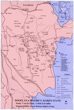
Quote: Three Pagodas

Um Pang had originally been a Karen settlement until Thais from the northern provinces of Chiang Mai, Lampoon, Lampang and Prae began to settle there. The village was at least 100 years old because records showed that in 1889, when Um Pang district belonged to Utai Tani province, it had been an immigration point for people from Burma. This might account for its name, which is said to derive from the Karen um pa/oom pa, meaning variously 'issue pass' or the bamboo cylinder used by Burmese travelers for keeping their immigration documents in. In 1898, Tak provincial administration made nearby Mae Klong an ampoe (present day Mae Klong Gao). With two district seats so close, it was inevitable that they should merge. In 1926, ampoe Mae Klong was subsumed under Um Pang district, but at the same time the newly enlarged ampoe Um Pang was reallocated from Utai Tani to Tak province. (p294)


Links for Um Phang
Map of Umphang
Umphang Airstrip
Ban Umphang Kee


Border Demarcation

The Death Highway wouldn't have been constructed if not for the singular border demarcation which makes Um Phang inaccessible by more moderate routes.

The British, after the victory of the first Anglo-Burmese War in 1826, repeatedly requested the Siamese Court to clear out the border demarcation issue. But it wasn't until 1868 that the two parties agreed on the border demarcation in principle, and it was as late as 1892 that the border was demarcated based on actual surveys.

In the west and south of Mae Sot, the Moei River defines the border demarcation. In the south of Mae Sot, several upstream tributaries join together to form the Moei River but, for some historical or political reasons, the one just south of Wa Lay is contextually regarded to be the mainstream Moei, though it's not the largest of all the tributaries. Even in recent years, the Burmese Government claims that the "actual" Moei runs north of Wa Lay, thereby claiming the entire Wa Lay area.

A little before this Moei mainstream/tributary reaches its origin, the land demarcation takes over on a series of mountain ranges, both high and low.


Death Highway

Chronology
1968Construction starts.
1969First attack by the CPT kills a deputy district officer.
CPT attacks continue throughout the year.
Tak Province hands over the construction to Highway Department.
1970CPT attacks continue.
Highway Department gives military training to its officials.
1972Major attack kills three policemen and wounds 20 workers.
Highway Department builds an airstrip in Umphang for strategic reinforcements.
CPT shoots down a police helicopter in Umphang.
1973Highway Department hands over the construction to a private company.
Major attack kills four Highway Department officials and five workers (km 43).
1975The road is completed throughout (still dirt). First motorized vehicle passes.
Construction continues to pave the road.
1982-83Mass surrenders of CPT activists after the Government's announcement of amnesty for insurgents.
1987The road is paved throughout.
Tourists start to arrive in Um Phang.


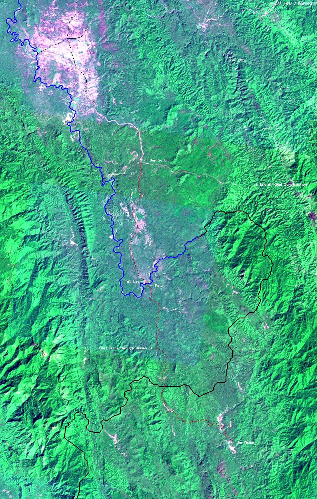
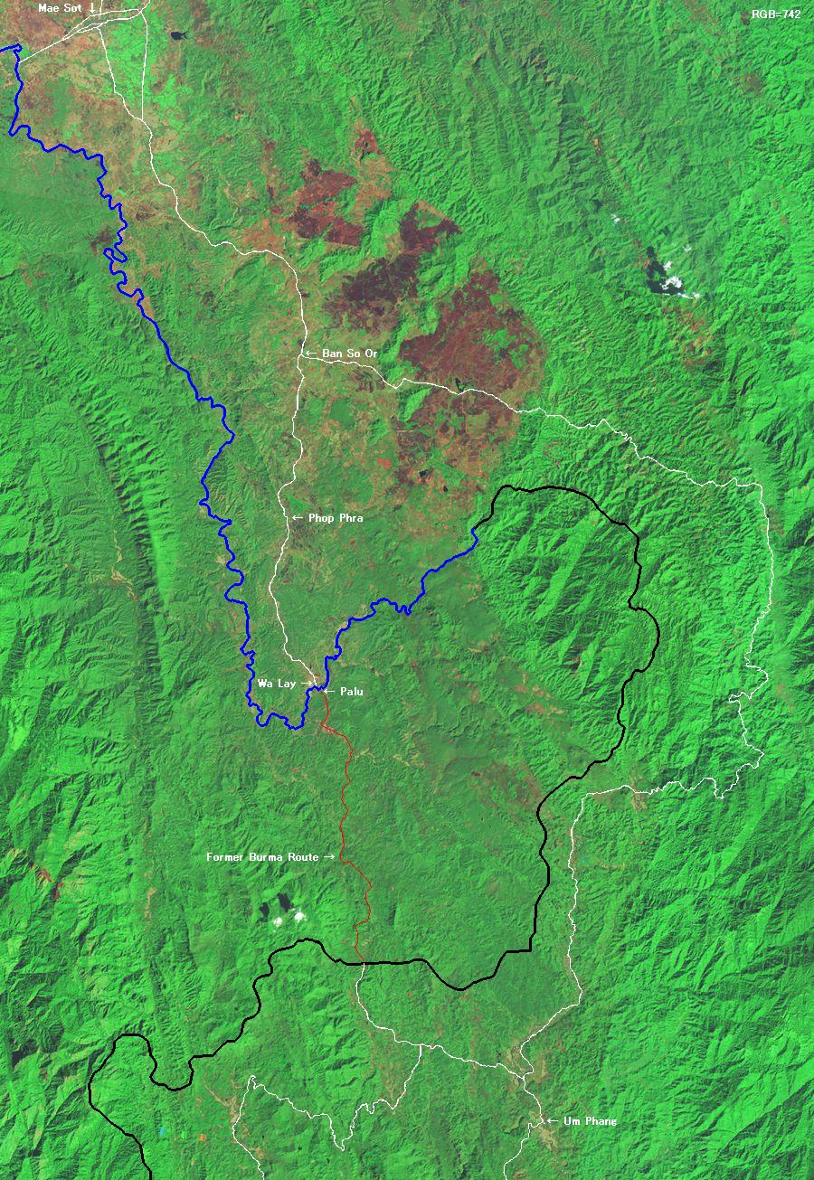
Quote: Three Pagodas

According to contemporary newspaper reports, some 30 road workers were attacked and killed at km-marker 43, apparently by Thai, Hmong and Karen CPT insurgents wanting to stop the road from penetrating Um Pang district (one of the main communist strongholds in Thailand in the 1960s and 70s). The attacks were one of the factors which had delayed completion of the road for so long. Following them, the Thai authorities deployed anti-communist KMT forces from places like Kae Noi to guard the project and its construction workers. The security situation was alleviated in 1982-83 with the mass surrenders in Tak province of hundreds of heavily-armed communist rebels and thousands of sympathizers. Nevertheless, until the late 1980s, when 'Death Highway' was finally finished (a decade late), the CPT remained active in the region south of Mae Sot. (p290)

Until recently, Um Pang had been even more cut off. Tong Lor Toed Yotin, the old man who ran the telephone booth at the 'Five Ways' (that nodal point in the village centre where five streets met), told us why. Until 1987, when the H1090 was completed, it had been difficult to get there at all. He had moved down to Um Pang from Mae Sot in 1968. In those days there had been no road, not even a track. The journey had taken the 'short' cut via Wa Lay through Burma - a four-day walk on foot or by elephant, camping three nights in the forest on the way. In 1971, people had begun building a cart track south from Mae Sot, so that rice could be transported from Um Pang up to town in four or five days. In 1975, the first motorized vehicles had started using the new cart track. Work on turning the cart track into a proper road had been unusually slow because of local CPT guerrilla activity and because of the two massacres near Rom Glao village No 2. As late as 1984, the 30-km route through Burma had still been in regular use, some people continuing to use it until, of course, it had been interdicted by the Burma army. In the rainy season, the new dirt road had often become impassable, leaving Um Pang cut off from the outside world for months on end. Finally, in 1987, 'Death Highway' had been metalled right through. (p291)

Bangkok Post Sunday Magazine / August 5, 1973

'Death highway'


Thirty men have died working on a road to link Umphang District of Tak with the outside world. Now, all work has stopped because of persistent terrorist attacks.

by Aroon Larnlue

Umphan Distrrict of Tak Province remains one of Thailand's most inaccessible regions. How remote is Amphoe Umphang? Well, you begin by counting the distance in days - that is when qualified by your mode of transport and the season. There is a choice - pack horse, ox-cart or on foot. Oh, yes, there's one other snag. To get there, you have to cut across through Burma, around a mountain.
  It was a continual source of embarrassment to Tak provincial officials to have to send government officers down pony tracks through Burma to reach Umphang District Office. So, in 1968, the Northern Region Development Committee financed the construction of a new road to run from Mae Sot to Umphang, largely along the Thai-Burmese border.
  It was known as a strategic road. Its completion would help the Border Patrol Police to guard against infiltration by terrorists from Burma and help prevent Burmese rebels from fleeing across the border to escape Burmese government suppression drives.
  Almost five years after construction work began, the road seems as far from completion as ever, with fewer than 60 of a total 135 kilometres completed. And thirty men have died.
  Now the machinery lies idle. The workmen have retreated. No one can be found who will risk his life to build the road.
  Everyone remembers that fatal afternoon, June 11, when more than 30 terrorists comprising Thais and hill tribesmen attacked a team of construction workers at kilomtre 43. Armed with machineguns and hand-grenades, the terrorists murdered and destroyed indiscriminately.
  Four Highways Department officers, and five employees of the private firm engaged in building the road died shortly after 3 p.m. Four others escaped with serious wounds, while all the construction equipment and machinery was set on fire.
  Since then all work has ceased. The firm, Sakhol Sathapat Co is bound by contract to finish construction of an 80-kilometre section of the road by 1974 without police security. Failing this, the company is liable to a fine.
  This attack was the latest episode in the black history of the construction of the Mae Sot-Umphang Road.
  It all began with a terrorist ambush back in 1969...
  Work started on this strategic road at the end of 1968, and it was estimated that the total distance of 135 kilometres - 90 of which were over mountainous terrain - would be completed by 1976 at a cost of not more than 900,000 baht a kilometre.
  Tak provincial authorities began building the road. They would be the first of three enterprises to unsuccessfully take on the task of construction

Ambush

  Early in 1969 a deputy district officer sent to oversee construction was assassinated at the roadside. In the ambush, several laborers were wounded and machinery was destroyed by fire. The officer died within 20 kilometres of the Mae Sot District Office.
  Throughout 1969, construction was hampered and harassed by Red Meo hill tribesmen and Karens led by a Thai leader receiving support from Communists abroad.
  By November, the provincial authorities had had enough, and handed over construction to the Highways Department.
  A month later, on December 17 a terrorist band of over 50 armed men attacked a construction crew and killed three, wounding several more. Again trucks and construction machinery were destroyed by fire.
  The following day, construction crews under Border Patrol Police escort were ferrying the damaged equipment to Mae Sot for repairs when they were attacked just 11 kilometres outside the town.
  A policeman was seriously wounded and equipment was again set on fire.
  Again, the next day, December 19, the terrorists continued to snipe at police and construction crews. A jeepload of Forestry Department officials on a mission to inspect and stamp logs in the area was attacked. The driver was killed and others wounded.
  For the rest of that month the terrorists kept up persistent harassment. They delivered written threats through messengers saying they would kill anybody working on the road. They claimed that when built, government officials would be able to "persecute them" easily.
  In April 1970 terrorists attacked workmen near kilometre 49 in a severe clash which left one Highways Department officer dead and nine policemen and security volunteers wounded.
  Work continued in fits and starts as attacks and ambushes continued. To combat this harassment, the Highways Department called for volunteers among its officers to undergo weapons training and learn jungle warfare tactics so that they would be able to fend for themselves if attacked.
  One thousand applied for the training and 300 were accepted and underwent a three-month course at the military training centre at Pak Chong, Nakhon Ratchasima.

Reinforcements

  Since then, volunteer courses have continued, and graduates are sent to work in strategic areas - such as this road, and those in Nan, also subject to communist terrorist harassment.
  These trainees receive the same benefits as policemen and soldiers on active duty.
  Yet, despite the presence of these trained officials, harassment continued on the Mae Sot-Umphang Road and work was frequently interrupted. At the beginning of 1971, three policemen were killed and 20 wounded in a major attack.
  Later that year, Highways Department officials built a runway for light aircraft at Umphang District Office to enable crack paratroops from Narewsuan Camp at Hua Hin to be mobilized as auxiliary reinforcements in case of emergency.
  Towards the end of last year, a police helicopter ferrying paratroopers to Umphang was downed by communist ground fire. Four died, including a police captain.
  The Highways Department then recommended to the Government that the construction be handed over to private enterprise in the hope that this would prevent communist attacks.
  This was done, and the highest bidder was the Sakol Sathapat Co Ltd who undertook to complete the remaining 80 kilometres of road by next year without police security. In the event that work could not be finished on schedule, then the company would be fined.
  So private enterprise took over.
  At first, the terrorists approached them demanding protection money. You pay us, and we won't harass you, they claimed. However, since this was in violation of the law against aiding and abetting communist activities, the company declined.
  Work continued.
  Then on May 24 this year, a force of about 30 terrorists, reportedly including Red Meo, Karen and Thais, fully armed, approached company officials and served an ultimatum that if work didn't stop they would attack and kill everybody engaged in construction.
  Six days later, the terrorists returned to the same spot where they had served their last ultimatum, opened fire on workmen, set fire to the vehicles and drove a jeep away into the jungle where it was later found abandoned.
  Work continued in defiance of these threats.
  Then, on June 11, at the same place as before - Kilometre 43 - a band of more than 30 terrorists descended out of the jungle at 3 p.m. Construction workers were then, according to the four survivors who managed to escape with injuries, mercilessly mowed down by terrorist gunfire.
  All the equipment, including tractors, cars, heavy equipment and other tools, was burnt.
  After half an hour, the terrorists turned away and disappeared into the dense undergrowth.
  Since then, all work on the road to Umphang has ceased.
  After nearly five years, work on the Mae Sot-Umphang Road has reached nowhere, and looks like going nowhere until authorities can flush out the terrorists.
  So far, the cost of building this road has been immeasurable in the terms of the number of lives lost.
  A monument at the Highways Department constructed in April of last year now bears all the names of department officials who lost their lives building this road - the road which has now been dubbed "Death Highway".


R 1117

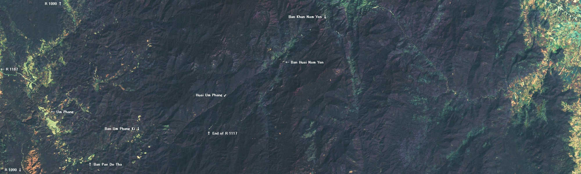
R 1117, if ever completed, was to be an alternative route to Um Phang. Its construction started in 1985, but suspended in 1987.

On the eastern side of the mountain range, coming from Kamphaeng Phet, the road mostly adjoins Khlong Khlung (river) to the mountain pass.

On the western side of the mountain range, continuing from the pass, the road adjoins Huai Um Phang (river) for some distance, then separates and changes its direction southwards. The Thailand Atlas shows another trek path that runs along Huai Um Phang all the way down to Ban Um Phang Ki.

Ban Um Phang Ki seems to be the outermost destination for adventurous tourists starting from Um Phang. In recent years, the village is establishing itself as a starting point for rafting down Huai Um Phang. There's even a regular accommodation for tourists. R 1117 from Um Phang, however, is only decently passable as far as Ban Pae Do Ta. The section between Ban Pae Do Ta and Um Phang Ki can be done on a 4WD during the dry season but, during the rainy season when most rafting tourists arrive, it's a two hours' distance on foot.

Whatever remains today of R 1117 across the mountain range lies in restricted areas. Its access is prohibited and a permission is most likely denied unless you have a very good reason or very good contact.

Quote: Three Pagodas

The path through Mae Wong National Park from Klong Lan to Um Pang via Um Pang Ki (even marked on some maps as the H1117 road) was absolutely forbidden, the way having been closed eight or nine years previously, with all villages en route shut down. The truth of this we found out to our own great cost when we once went to a lot of trouble trying to take a short cut from Kampaeng Pet to Um Pang. (p296)

Bangkok Post / March 19, 2002
BORDER
Surayud orders road project discontinued
Army does not want to destroy forest

Wassana Nanuam

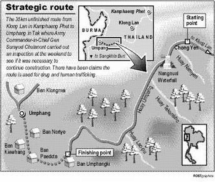
After a weekend survey led by the army chief, it has been decided not to build a security road linking Kamphaeng Phet's Khlong Lan to Tak's Umphang, to protect the environment.

Army commander-in-chief Gen Surayud Chulanont spent three days and two nights from Friday until noon Sunday trekking 35km across Tanaosri Range's 10 mountains and more than 90 rivers.

The National Security Council and Forestry Department asked the army if construction of the unfinished Khlong Lan-Umphang security route should be resumed.

Gen Surayud said the army would not support extension of the route, which was not useful for military operations because the road was up to 50km away from the border.

Under the current policy, security roads must be no farther than 2-3km from the border.

"If we allow the construction of another 33km section of this road, we will lose abundant forests and a lot of rare wild animals.

"It's not worth losing forests and wildlife habitat even though it would make travel to Umphang more convenient and support the development of Tak.

"The army is against the construction. All forests disappear wherever roads are cut,'' he said.

The project began in 1985 and was suspended in 1987 after completion of a 115km section, since the army saw no security benefit and did not want to see deforestation.


Gen Surayud Chulanont inspects a 35km-long drug smuggling route in Umphang district, in Tak, over the weekend. _ WASSANA NANUAM
It was reported the Naresuan task force's 12-member patrol team was sent beforehand to ensure safety for Gen Surayud, who was the first army chief to survey the route.

Despite no trace of drug smuggling found along this route during this trip, the army chief ordered routine patrolling by the Naresuan task force to combat drug trafficking.

"I envy the villagers here who live among pristine nature. Please help protect this. Do not cut down trees and, more importantly, do not fall prey to drug gangs,'' Gen Surayud told Karen villagers at Umphang Kee village in Tak during his trek.

Umphang Kee is a self-defence and drug-free village under the army's "strong community project''.


Dooplaya

A simplified view is that across the border is Burma. However, this simplification ignores internal splits and struggles within the national boundary. Historically, Thailand shared borders with buffer states like the Shan, Karenni, Karen and Mon, rather than the Burma Proper. Subsequent colonialism in the 19th century and international politics after the WWII, however, dictated today's sorry state of Burma.

From where Thailand meets the Salween River down to some distance south of the Three Pagodas Pass, Thailand borders with the Karen State which is, within today's international geopolitical context, is regarded as a part of Burma. Ugly military struggles still persist today between the Karen soldiers and Burmese soldiers, and the area is replete with landmines planted by both parties.

The Karen State is divided into six administrative districts and, from Mae Sot downwards, it is Dooplaya District that Thailand borders with. Especially, the area protruding into Thailand is called Eastern Dooplaya.

Thumbnailed on the right is a map of Dooplaya District compiled by the Karen Human Rights Group in 2002. The map doesn't show details of Eastern Dooplaya, but it can be assumed that the old Burma Route connecting Wa Lay and Umphang hasn't been upgraded to a regular road yet.

On recent Landsat images, traces of dirt roads in Eastern Dooplaya can be discerned. These roads are probably constructed by the Burmese Government with the forced labor of local villagers to allow Thai logging companies to deforest the area.


Links for Dooplaya
Dooplaya
Eastern Dooplaya
Photo Album


Image Processing

1. From the ESDI


PathRowWRSSensorRGBDate
Image-1130492TM732Dec 21, 1989
Image-2131482TM732Feb 3, 1989
Image-3131492TM732Jan 18, 1989


PathRowWRSSensorRGBDate
Image-4130492TM742Dec 21, 1989
Image-5131482TM742Feb 3, 1989
Image-6131492TM742Jan 18, 1989


To create the top image (mosaic), I joined three frames. Then I overlayed following features:
1. River Border: I traced the Moei River on the image.
2. Land Border: I adopted the border line from the SmartMap/Thailand.
3. Roads: R 1090 is clearly traceable on the image for about 70% of its total length, barely traceable for 20%, and hardly traceable for the remaining 10% which requires imagination and deduction from surrounding geographic features. The SmartMap/Thailand proved to be inaccurate and unreliable in this area as far as roads are concerned.

I reduced the size (thereby resolution) of the mosaic by 900/2200 (=41%) to present it on the web.

The image of R 1117 was composed from a single frame of Image-1. It keeps the original resolution.


2. From the GeoZoom


PathRowWRSSensorRGBDate
Image-7149481MSS231Jan 26, 1973

The 1973 image was composed from a single frame of Image-7. It keeps the original resolution.

Both for the 1989 ESDI image and 1973 GeoZoom image, the Burma Route connecting Wa Lay and Um Phang is only about 80% traceable. The rest was imaged from geographical features.

The GeoZoom offers more recent images of the area (1985 - 2002) but their contrasts are not as clear as the ESDI image.

Hosted by www.Geocities.ws

1