The central strip of the Huelva
province, running from the border with Seville in the east to Portugal
in the west is a sparsely populated area of sometimes remarkable countryside.
To the east, Andévalo y Parque Minero is characterised by the
dramatic Minas de Río Tinto, an area where the landscape is
surreal and dramatic. The mines in this area were once controlled by
the British, who have left a legacy of colonial buildings and sentiments
in the area. To the west, the Andévalo is separated from Portugal
by the Río Guadiana and the countryside in this area is scattered
with rural white villages surrounded by agricultural land.
Valverde del Camino
The largest town in the area with a population of 13,000, Valverde
is an uninspiring town originally the site of a roadside inn. Valverde
expanded a couple of centuries ago when it became concerned with
commerce and industry. The town became the transport hub for the
nearby Río Tinto mines, connecting the mines with Huelva in
the south. In 1837, a local cobbler won an international competition
and Valverde became synonymous with the quality footwear that is
still made here today. Valverde is also home to the last craft shop
in Spain that is dedicated to producing cowbells. The artisan who
runs the shop produces all kinds of animal bells from minute bells
for ferrets through to huge bells for bulls and the bells are sold
across Spain. On the outskirts of Valverde is a large mansion covered
in pebbledash that was originally built for the directors of a Liverpool
railway company who were in charge of the Río Tinto rail line.
Valverde has supermarkets, shops and other services and is the only
town of any size in the area. Valverde is 35km from Huelva and 70km
from Sevilla, 80km from the airport at Seville.
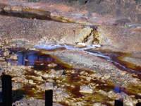
Mines of Río Tinto
The Río Tinto mines just near to the town
of Minas de Riotinto are reportedly the oldest mines in the world.
They form a spectacular sight, existing today as a huge cavity
in the Sierra de Aracena. The resulting landscape is a surreal
affair, layers of soil and rock have been removed in search of
silver, copper and iron ore among other minerals and the earth
is coloured in pinks and browns, yellows, reds and greys, the hues
of which change with the sun. The scale of the mining in the area
over the years means that today the crater is several kilometres
across, and there is still mining continuing in the area, although
it is much declined today. The mines are named after the river
that flows through the area, so called because of the reddish streaks
to the water created by the unearthed minerals.
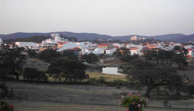
Minas de Riotinto
The town of Minas de Riotinto is a relatively
new town with a population of 5000. Minas de Riotinto consists
of parallel rows of white houses situated on the slopes of a hill.
Evidence of Minas’s history as a mining town is prominent.
The headquarters of the mining operation were situated in a fine
but decaying Edwardian building near to the square and you can
still see a row of ticket windows from which the miner’s
wives would collect their husband’s money. Today, the building
is utilised by the Río Tinto Foundation who have amassed
much documentation connected to the mining industry. There is a
mining museum on the hill above the building and the remains of
the old railway station can be seen further down the hill. Near
to the village is the captivating and immaculate former British
Colony of Bella Vista, complete with a village green, a Presbyterian
church and hedged lawns. Formerly used by the British in charge
of the mining operations, the houses are currently used by the
medical staff of a newly opened General Hospital, which is one
of the largest in the Huelva Province. The former colony continues
to propound English traditions and customs; in front of what was
one the British Club, there are still tennis lawns, and the building
inside is decked with hunting trophies, women only teas are held
weekly and there is a male-only bar with a billiard table. All
very English. True to form, there is a golf course at Riotinto
that was built in the 19th century at the mines and was one of
the first to be built on the European continent, along with a football
pitch. Minas de Riotinto is 8km from Zalamea la Real and 26km from
Valverde.
Nerva
Originally known as Zalamea la Vieja, Nerva is an old mining town of
6500 people. The mines of Riotinto are reputed to be King Solomans
legendary mines and along with Zalamea la Real, Zalamea la Vieja
was named after King Soloman. Nerva is 4km east of Minas de Riotinto.
To the northeast of Nerva, 10km away is the village of La Granada
de Riotinto with a population of 250. It is a quiet village with
white houses surrounded by wooded countryside. 6km west of La Granada
is Campofrío with a population of 900. There is a historic
bullring at Campofrío.
Zalamea la Real
A pleasant village of 3500 inhabitants, there are wonderful views from
Zalamea over the surrounding countryside with its forested, rolling
slopes. Zalamea is famous for its anis and its aguardiente. The village
is 18km from Valverde in the south, situated on the main N435 road
that runs south to Huelva. 4km west of Zalamea is the village of
El Campillo with a population of 2500. Southeast of Zalamea, the
village of Berrocal lies near the border with Sevilla. There are
a couple of restaurants and a guest house in this village of 400
people.
Calañas
An attractive town of 5000 people, Calañas consists of white
houses with tiled roofs with a parish church, Nuestra Señora
de Gracia, at its centre. Near the village is the 16th century hermitage
of La Virgen de Coronada. At the beginning of April each year, a Romería
takes place when, amid festivities, a statue of the virgin is carried
to this hermitage. Calañas is located in the heart of Andevalo
on a crossroads of 2 main roads of the area. The rail line that runs
north from Huelva passes through Calañas and there is a train
station just outside the town. Calañas is 16km northeast of
Valverde.
El Cerro de Andévalo
This beautiful village in the Andévalo countryside has a population
of 2000. It is famous for the pilgrimage that takes place here on the
first Sunday in May where the “jamuguera” costumes worn
by the locals are particularly colourful and original. During the fiesta,
traditional copla songs, folk dances and local fandangos are all performed
as the pilgrimage makes its way to the hermitage of San Benito Abad.
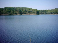
To the east of El Cerro is an area of countryside containing a couple
of rural villages and the 7km long Sotiel reservoir. El Cerro is 22km
north of Calañas on country roads.
Cabezas Rubias
This relatively unvisited village of 1000 people is so named because
of the long-standing connection of the English with the mining activity
in this area, Cabezas Rubias meaning “Blonde Heads”.
The village is known for the festival of San Sebastian, which takes
place on the 20th of January, the pilgrimage of San Benito in May
and the Feria which is held in August. The local fandangos are performed
at all the fiestas. Cabezas is 22km northeast of Calanas and 42km
from Valverde, the nearest service centre.
Villanueva de las Cruces
The tiny village of Villanueva with a population of 500 is situated
in the hills of Andévalo, surrounded by attractive countryside.
The village contains a lovely whitewashed church, Santa María
de la Cruz with a two-tiered bell tower and also the hermitage of
San Sebastion. Villanueva is 15km south of Calañas on small
country roads.
Alosno
In the middle of Andévalo, Alosno is a town of 5000 around which
can be found the remains of many old mines. Today an agricultural town,
the countryside surrounding Alosno consists of cork forests and olive
groves. Within the town, the chapel of Señor de la Columna and
the church of Nuestra Señora de Gracia are interesting sights.
The town is renowned for being the main centre for the fandango in
the Huelva province. There are a number of shops in Alosno and the
town is 40km from the capital of Huelva.
Puebla de Guzmán
A community of 3000 people, Puebla de Guzmán contains the large
parish church of Santa Cruz with its baroque tower and tiled roof.
There is also an attractive whitewashed chapel in the village with
a baroque façade, backed by a dramatic rocky outcrop. There
are fantastic views of the surrounding area from the nearby Hill of
Aguila, which serves as a natural look out. A pilgrimage to this hill
takes place on the last Sunday in April. Guzmán is 15km northwest
of Alsono and 50km north of the coast.
Villanueva de los Castillejos
A village of 2500 inhabitants, Villanueva consists of a series of streets
spread out around its baroque church whose tower rises out above
the rooftops. A lively carnival is held in Villanueva during February;
on Easter Sunday the pilgrimage of Nuestra Señorade de las
Piedras Albas is held and a popular Feria takes place on the last
Sunday in August. Adjacent to Villanueva is El Almendro, a small
village of whitewashed houses with red tiled roofs built under a
small hill.
Sanlúcar de Guadiana
Sanlúcar is situated right on the border with Portugal, although
you have to travel 25km south to actually cross the border due to the
Río Guadiana, which separates the two countries. A village of
400 inhabitants, Sanlúcar’s whitewashed houses look over
the river to the green hills of Portugal in the west. Testimony to
Sanlúcar’s position as a border town are the remains of
San Marcos castle to the north of the village. The village is a quiet,
relaxing place, surrounded by lovely countryside.
Northeast of Sanlúcar is El Granado, a
rural village of 600 inhabitants. The area to the north of El Granado
contains the Minas de Santa Catalina and further north still, behind
the Sierra Madronera is the Chanza reservoir, a large area of water
through which the Portuguese-Spanish border runs.
San Silvestre de Guzmán
A quiet village of 700 inhabitants, San Silvestre has a relaxed atmosphere.
The main Plaza de España is pleasantly shabby, the façade
of the white chapel is in need of paint and the road is uneven, but
bright flowers erupt from the ground beneath the palms in the centre
of the square. San Silvestre is 8km west of the Portuguese border
and 20km from the border town of Ayamonte in the south.
San Bartolomé de la Torre
Archaeological evidence shows that the area around San Bartolomé has
been inhabited for thousands of years. Today it is a town of 3000 inhabitants
with a particularly interesting medieval tower, which gives the town
its name. The main economic activities in San Bartolomé are
agriculture and cattle farming and the town became greatly modernized
in the eighties when the cultivation of strawberries and oranges was
introduced to the area. The locally produced bread and confectionaries
are famous throughout Huelva for their quality. San Bartolomé is
30km from the province capital of Huelva.
Paymogo
In the northwest of the Andévalo area, 5km from the border with
Portugal is the relatively isolated village of Paymogo with a population
of 1200 people. Paymogo contains a striking 17th century church of
Santa María Magdalena. The church is a protected monument, built
of stone with an interestingly tiled bell tower roof. Paymogo is situated
15km off the N493 main road which runs between Valverde and Rosal de
la Frontera on the Portuguese border.
Santa Bárbara de Casa, a village
of 1200 people, is situated on this road, 20km south of Rosal
de la Frontera.

Andévalo
y Sierra
Santa Bárbara de casa
Juani y Chema |