
Welcome to Asheboro, NC and beautiful Randolph County!
|

|
Click on Picture to enlarge.
Sorry, your browser doesn't suppor Java. -->
 �
�  �
�

Today's Weather Forcast
Click anywhere on Banners below, to see the forcast for High Point, NCor for our friends down in Asheboro, NC
 | |

|
|---|
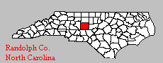
Asheboro is located in Randolph County, North Carolina. We are located in almost center of the state. Asheboro is the county seat of Randolph County, and is also the home of the NC Jaycee's and the NC State Zoo.
There is so much to do and see in Randolph County. Below is a listing of some of the exciting things one can find when visiting Randolph County, NC.
The present town of Asheboro is approximately the center of Randolph County, and is the center of the state. Asheboro is
situated on a beautiful ridge of large hills or mountains, as they are called locally, with gentle rolling plains. The highest of these
mountains, overlooking Asheboro from the northwest, is Caraway.
There are two river systems, Uwharrie and Deep, in the
county, with the third rising near Asheboro which is called Little River.
In the year 1793, the county paid ten shillings for two acres of land for the construction of public buildings, and on this land the
present town of Asheboro was built in 1776. In which Asheboro is celebrating its Bicentennial this year. "Asheborough" as it
was spelled then, was named in honor of Samuel Ashe, who was a distinguished soldier and Statesman during the American
Revolution, and afterwards became governor of the State.
Popular opinion played a major part in Asheboro's location when
residents of the southern part of the county objected to traveling so far to do business at the courthouse. They wanted a county
seat in the center of the county.
Around the courthouse, stores sprang up as the population increased, creating demand for goods and services. The Male and
Female Academies prospered, as did the new churches. The village was a trading center for the gold mining interests in the
county and would soon become a toll house stop on the Plank Road.
Asheboro followed the county's lead with similar views toward secession prior to the Civil War. During this time, Jonathan
Worth emerged as the major force in Asheboro's business, political and educational matters.
Elected to the state General
Assembly four times representing Randolph County, Worth served as State Treasurer during the Civil War and was the North
Carolina Governor from 1865 until 1868.
Asheboro grew industrially with the arrival of the railroad in 1889. Textiles and furniture ruled the economic picture in
Asheboro, until the mid-1950's. 1960's and early 1970's with the arrival of diversified industries such as Goodyear, Arrow
International, Eveready Battery, Klaussner Furniture Industries and Georgia Pacific.
As Asheboro entered the Twentieth Century, it began receiving notice that it was a transportation center, primarily because of
the excellent road system and its central location in North Carolina.
Asheboro is famous for the North Carolina Zoological Park, the Seagrove Area Potteries, the Richard Petty Museum, and the
American Classic Motorcycle Museum.
Randolph County was formed in 1779 from Guilford County. It was named in honor of Peyton Randolph, member of the
notable Virginia family. He was first president of the Continental Congress (1774-75).
Randolph County is in the central section
of the state and is bounded by Chatham, Moore, Montgomery, Davidson, Guilford and Alamance Counties. It's present area is
790 square miles and its present population is 108,000 according to the 1991 census.
Asheboro was established as the county
seat on the land of Jesse Henley in 1796. A new courthouse was authorized to be built in 1819 at Asheboro.
Randolph county serves as home to an urban and rural population, last taken in 1997, of approximately 119,306 residents. The
average elevation of Randolph County is 870 feet above sea level. It covers approximately 790 square miles in the very heart
of North Carolina soil.
The average annual temperature in Randolph County is 60.1�F. January temperatures average around
41.8�F, while July's average is 78.0�F. Annual precipitation varies with average annual rainfall at 44.8 inches and 6.8 inches of
average annual snowfall.
originally Bush Hill, was dominated by Quakers, and this led to a change in the name to honor John Archdale,
Quaker Governor of North Carolina (1694-96).
(originally Asheborough) was named for Samuel Ashe, governor (1795-98).
was named for the water fall on Deep River.
honors the eminent posture of a native, one Tom Bray.
was named for Jesse Franklin, North Carolina Governor (1820-21).
once Liberty Oak, named (perhaps) because Union soldiers camped here during negotiations between Sherman
and Johnston for surrender of the Confederate Army.
once was Columbia. In 1878, W. H. Watkins and associates bought the mill and changed the name to honor
General Stephen D. Ramseur, Watkins' Old Commander.
was named for a railway official, Samuel Seagrove.
Randleman's first name was Dicks, named for Peter Dicks, a pioneer mill man. It was renamed for John B. Randleman
who with John H. Ferree in 1872, acquired a cotton mill in the town.
was named for Colonel John W. Staley, a Confederate officer.
The name of this town always puzzles newcomers. For the record, we repeat: At a town meeting, there were so many queries of
"Why not name the new town this" or "Why not name the new town that" --all without agreement-- that finally one fellow rose
and said, "Why not name the town Whynot and let's go home?"
was named for either Dr. J. M. or Hal Worth, who built a cotton mill here, or perhaps for Governor
Jonathan Worth.
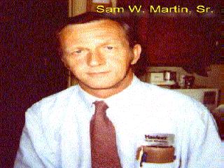
My name is Sam. This site is designed to introduce you to my Home Town of Asheboro, NC
Historical Information of Asheboro/Randolph County
(This information courtesy of Asheboro/Randolph Chamber of Commerce)
Please be sure to visit us today!
Stories About Names
ARCHDALE
ASHEBORO
CENTRAL FALLS
ERECT
FRANKLINVILLE
LIBERTY
RAMSEUR
SEAGROVE
RANDLEMAN
STALEY
WHYNOT
WORTHVILLE
Another Randolph
In 1830 a hostile militia law was aimed at the Quakers and two years later the Raleigh Register reported that "Sixty-nine
individuals of the Society of Friends have removed from Randolph alone, this fall, to the state of Indiana". So many followed
them that there were enough Randolph Quakers in an Indiana community to organize a county which they named Randolph.
Covered Bridges
One of Randolph's famous covered bridges remain and will be preserved. It is over a tributary of Little River, 1 1/2 miles from
the community of Pisgah, southwest of Asheboro. It is not now in use. Randolph's bridges are "famous" because there were so
many of them. In 1933, no less than 51 covered bridges were still in existence. There are two explanations given; "Some say it
is just because Randolph was a progressive county and wanted to improve communication." Another is that this county has
always been "close politically." So the candidates running for office competed with each other in pledging to build bridges.
Visit SoGoCity
|
NC Zoo located just South of town off Old Cox Rd., now known as Zoo Parkway. |
Seagrove Pottery Center Information, facts, prices, & more!. |
|
Larry G. Davis� Versatile Guitarist |
The Richard Petty Museum learn about 'The King' of NASCAR and racing history |
|
Caraway Racetrack the best in stock car racing |
Randolph Community College world famous Photography Curriculum. |
| Pisgah Covered Bridge a historic and beautiful piece of preserved history. |
The Courier-Tribune Our Local Newspaper |
While here, why not visit our neighbor,
High Point, NC

Some Favorite Links
Sign Guestbook
View Guestbook
You are visitor number:

to visit our site; as of 04/11/2006 @ 05:25pm!
Back To Index
While you are here, why not visit my
B.J. Snuggles Page
www.flickr.com
This is a Flickr badge showing photos in a set called High Point Market Time. Make your own badge here.
This site is hosted by:

Get your own Free Home Page
I am a member of

Email Me
Back To Index
This site created and maintained by:
S & M Creations
701 Arbordale Ave.
High Point, NC 27262
EMAIL:[email protected]
ALL RIGHTS RESERVED
Created: 04-22-1995 / 5:27pm
Last modified: 04-19-2008 /09:30 pm; E.S.T.
Have A Great Day!
Back To Index
Some Favorite Links
Some Favorite Links
to visit our site; as of 04/11/2006 @ 05:25pm!
Back To Index
While you are here, why not visit my
B.J. Snuggles Page
Get your own Free Home Page
I am a member of
Back To Index
|
701 Arbordale Ave. High Point, NC 27262 EMAIL:[email protected] ALL RIGHTS RESERVED
Created: 04-22-1995 / 5:27pm
Last modified: 04-19-2008 /09:30 pm; E.S.T. |