These HST images provide high resolution detail showing how dust is being infilled or eroded from individuak craters, wind streaks, mountain ridges, and deep valleys. Combined with ground-base monitoring and similar-scale images obtained concurrently by the MArs Global <Surveyor spacecraft but in different wavelenghts, the HST data will help to constrain both the composition and mineralogy of the dusty and darker regions, as well as meteorological models of the dust storms themselves.
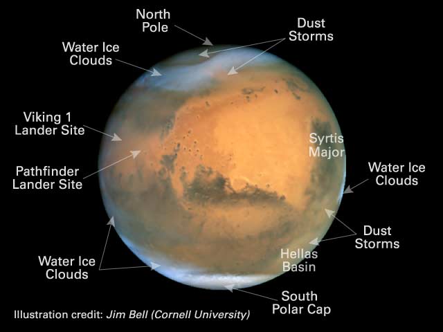
Other prominent features in this image include an extensive south polar cap (the withish region near the bottom) consisting of mostly dry ice (CO2) that condensed out of the MArtian atmosphere during the long south polar winter (the image was obtained very close to the first day of the southern spring season on Mars), a "hood" of blueish-white water ice clouds at high northern latitudes (top of image), prominent early morning (left side) and late evening (right side) blueish-white water ice clouds forming high up in the extremely cold Martian atmosphere, and a thin band of water ice clouds/haze that stretches across the "tropics" of Mars (across the middle of the image). These clouds and polar caps are known to wax and wane as Mars goes through its Earth-like yearly cicle of seasons. In fact, the equatorial cloud belt is much less developed than we have seen in previous HST images, when the planet was much further from the Sun and thus the atmosphere much colder. However, the corresponding decrease in water ice clouds is compensated by the increased in dust storm activity seen here, since dust storms tend to be more prominent during southern spring and summer seasons when the planet is closer to the Sun. These HST images are helping astronomers fill important gaps in the seasonal coverage of observations and models designed to help predict the timing and extent of future dus storm activities on Mars.
Because of their unique temporal and spectral coverage, images like these being obtained from HST are contributing to the selection of landing sites for the next round of NASA Mars rover missions. The NASA Mars Exploration Rovers will launch in 2003 and land in early 2004, exploring two different regions of the surface for at least 90 Martian days each. Images from HST are helping to define the mos interesting potential landing sites by providing information on the surface mineralogy and the seasonal/annual meteorological conditions of dozens of candidate landing locations.
These spectacular HST images provide a glimpse of what we can expect to see in 2003, when Mars makes it closest approach to Earth since 1924 (35 million miles, or 56 million km), and is closer than it will be again until the year 2287!. During 2003, Mars will be 25% larger in the sky than during 2001, and surface features as small as about 7.5 miles (12 km) will be resolvable by HST. Between now and then, HST and ground-based observers will continue to monitor the red planet for new signs of surface changes and meteorological activity that will further enhance our understanding of this dynamic world. |