Great Barrier Reef
Introduction
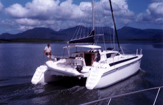
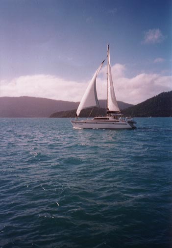
I'm sailing with Mark (36) and Donna (30) aboard Maverick Dream, a 42 ft catamaran. Mark and Donna have been living together for the last couple of years in Brisbane and the US. Mark owns a computer company that makes training CDs and Donna is the business manager. Both are semi-retired and ready to try the cruising life. This is Mark's first boat and Donna has never sailed before. Mark has crewed on several boats when he was younger and would like to sail the boat around the world. Donna for never having sailed before is very sharp. Both are dive masters.
I was invited on board to help outfit the boat and get them started with their new lifestyle. This was my 1st time sailing on a large catamaran and I was very impressed! Sorry about the poor quality pictures.
The Trip
After 26 hours of flying and waiting in
airports, I finally made it to Brisbane, Australia on July 26, 2000. The flight
from LAX to Syndey crossed the international dateline, so I missed July 25.
The boat was docked in Manly, a small town just outside of Brisbane, with lots of small shops and nice places to eat. I stayed on the boat by myself for a few days and met some of the locals at the Manly Hotel and Pub. The local beer is XXXX and at first I thought the town was filled with sex shops. XXXX is a good beer and I should know after celebrating one of the local's birthdays.
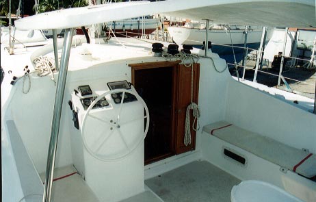
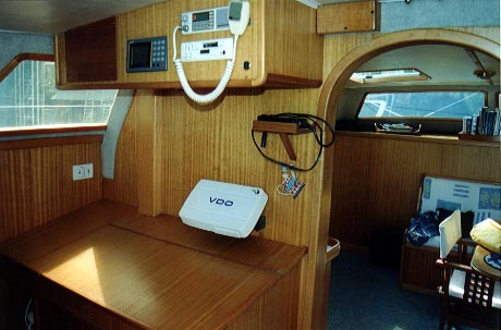
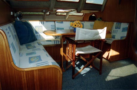
Maverick Dream has a great cockpit, navigation station, and 1st class salon:
The first week was mostly working on the boat and buying lots of supply. I got
to see a little of Brisbane during the shopping trips and we went to see a very
funny English movie one night. To check out the boat and all systems we did an
overnight trip to Moreton Island. The anchorage is just north of the Tangalooma
Resort and inside a sand bar with 6 large ship wrecks.
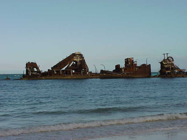
It was a little weird being anchored between the big wrecks and the beach, but the protection was great! I think the ships were sand dredges that mined sand from Moreton Island before it became a park. It is easy to see where the sand was mined from the high dunes all along the beach. The Tangalooma Resort was the sight of a whaling station, but not much of the old station remains. The Moreton Island website is http://www.moreton-island.com/index.htm. We had a nice sail back with light winds right on the nose.
With several items still on the to-do list, we decided to slip the dock lines at 5 am on Aug 2 and start the trip. The first leg was back to Moreton Island, across Moreton Bay via the main channel, and north up the coast to Mooloolaba. The 60 mn trip was just over 11 hours and was great sailing in light winds and smooth seas. Other than about 10 mn, we flew the spinnaker all the way. Along the way, we sailed next to (not an official race) a 32' cat, called KatieKat, and later met everyone in port. They have a nice sailing website (www.katiekat.net ) with lots of pictures.
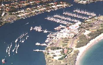
We docked the boat at the Mooloolaba Yacht Club on one of the long piers. The yacht club is just inside the mouth of the Mooloolah River and on a long peninsula. Transportation around town was by dinghy through a series of canals starting just up the river. Now how often do you get to go to the local shopping mall with a wet butt by dinghy?
The Mooloolaba beach is just across the
peninsula with a park and walking trail that follows the beach to the next town. Definitely,
on some top 10 list! The first night in port, we followed the trail to a
'locals' place called the Irish Pub and I am happy to report they had XXXX. Mark
and Donna don't drink, so I only had a pint, mate.
The weather turned bad in Mooloolaba and we decided not to leave as planned.
Joe, from KatieKat, rented a car and we drove to the Lone Pine Koala Sanctuary.
Koalas are great! After three days of waiting on weather, Mark got ants in his
pants and we decided to leave in light winds and rain. The plan was to head
directly for Lady Musgrave about 220nm to the north. Four or five hours out to
sea, the wind built to around 25 kts with gusts over 30, 6-8 ft seas, etc, etc.
Donna got seasick, Mark wasn't feeling very well, and I was worried about the
boat coming apart with all the banging and vibrations from waves hitting the
bridge deck. About 4am, we decided to try and anchor off Double Island Point,
the only anchorage before Lady Musgrave (still 160 nm away), by the outside
route. The anchorage worked out OK, everyone started feeling better, and the
boat was still in one piece!
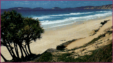
Double Island Point is in the upper left corner
of the picture and we anchored off the cliffs in the upper right corner. Rainbow
Beach and the the cliffs are beautiful in the morning sun! With all the fun from
the night before, we decided to take the Great Sandy Straits (inside protected
route) around Fraser Island. To enter the straits, we needed to cross Wide Bay
Bar on a rising tide and pulled the hook around 9am. We had heard lots of
stories about the bar, but it was a piece of cake. Never trust anything a person
is saying with a XXXX beer in their hand! The Great Sandy Straits is a lot like
the ICW on the west coast of Florida but with no people or development. We
anchored at Garry's anchorage on the west side of Fraser Island. Very nice spot
and great protection. We tried to hike to Garry's lake, but the trails were not
marked very well and we only saw the lake from a distance. If only we could have
found Garry's trail.
The next day we motored in light winds up the
straits to Hervey Bay and on to the Burnett Head Marina, back on the
mainland. Hervey Bay is the official start of the Great Barrier Reef. The
marina is just inside the mouth of the Burnett River and a short walk
from the very small town of Burnett Head. A nice guy at the marina gave us a
ride to Bundaberg, about 10k inland, to do some shopping and sightseeing.
Bundaberg is a scenic town on the Burnett River with lots of backpackers. The
town is famous for the Bundaberg Rum Factory and I'm sorry to say I missed the
tour and free samples.
After a few repairs, we were up early for the 55nm trip to Lady Musgrave in
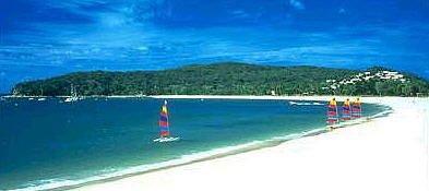
light winds that were right on the nose. Lady Musgrave is a coral atoll, with a
small island and a lagoon anchorage.
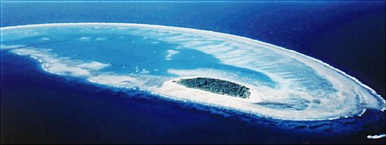
We anchored overnight just off the left side of the island inside the lagoon. Look on the internet for some other unbelieveable pictures. The snorkeling was great and it was the first time I've seen blue hard coral. I hated to leave so soon, but around 5pm we pulled the hook for the 90nm overnight trip to Great Keppel Island. It was a easy broad reach in 12-15 kts winds and 3-4 seas, but I didn't get much sleep.
We planned to anchor off Svendsen's Beach, but by mistake anchored in Butterfish Bay. Hey, it was a long night! Mark and I decided to go for a hike to the resort on the island, but because we anchored in the wrong spot, we also took the wrong trail. Anyway, it was a nice hike ALL around the island and just about the longest way to the resort. We had been hiking most of the afternoon and decided to hire a speedboat for the trip back. With 200hp on a small 15' boat, it was a fast, fun ride back!
Just before dark, we decided to move the boat to the resort, have a shower, and
eat ashore. The chief executive dishwasher (me) really liked it! Great Keppel
has lots of great beaches just like the one we anchored at by the resort above.
Next morning it was up early for the 40nm trip
to Port Clinton in 10-12 kts winds, just forward of the beam, and 3-4 ft seas.
It was cloudy day with light rain and our SOG averaged about 4 kts. We arrived
just before dark and didn't get to go ashore. Port Clinton has no development
and is only used as a miltary practice area.
Next morning it was up early for the 25nm trip to Cape Townshend with light
winds right on the stern. It was a great, but slow spinnaker run all day. The
head plugged during the day and we had a fun late afternoon and night trying to
fix the #@!$% thing. So much for watching the sunset with a cold XXXX in your
hand! We needed a new hose for the head and decided to make tracks for Mackay,
the nearest city.
Next morning it was up early for the 55nm trip to Digby Island in light winds.
To use the head: attach a safety harness to the dinghy davits, place feet firmly
on the duck board, and . It worked pretty well, but I still feel using a bucket
is more classy.
Next morning I got up early, snuck off the boat, and did a little hiking around
the island. It was a cattle rancher's dream with a nice little pond and deep
grass all over the island. I almost got stuck once! When I got back to the boat,
Mark and Donna were swimming and everything worked out OK. After a short morning
break, it was on to Mackay, 45nm miles away in light winds. Mark and Donna
went into town for dinner and I stayed on the boat.
Mark and Donna were planning to leave the boat for about two weeks, the trip was
starting to feel like a delivery, and I decided to leave
the boat. The original plan was to take our time with lots of sightseeing
and for me to be on the boat for another 6 weeks. A new crew member was planning
to arrive just after Mark and Donna returned, so other than missing out on
some repairs while they were away, everything worked out OK. The good news is
that it probably would have taken me 4-5 months to cover the same area with the
'smell the roses' approach I used on Music. Mark and Donna are nice people and
it was a good sailing trip.
I found a cheap motel room in Mackay and headed for the Eungella Rainforest the
next day. It was a nice day and I made the hike to the Araluen and Wheel of Fire
waterfalls in the Finch Hatton Gorge part of the forest.

The Broken River runs through the highest peaks
in the rainforest and is one of the few places to see Platypuses in the wild.
They are smaller than I expected but great to watch. I saw at least 10 in
different places while walking along the river. A film crew working for David
Attenbough were at the river filming for a nature special and caught two mating
the day before. No, it wasn't a beaver and duck fooling around.
I stayed in Mackay for another two days looking around the town. One good thing
about Australia is that every little town has lots of parks with walking trails.
I walked at least 5 miles per day and had a great time. After Mackay, I
caught a bus to Airlie Beach. They actually had free 1st run movies on the bus
which made the trip just fly by.
Airlie Beach is a big party town for backpackers and yes, XXXX is available everywhere. I had a great time one night with some backpackers from England watching Survior on a big screen TV in a pub. The only problem was they didn't like the show or XXXX? Anyway, we had a good time talking about the show and English beer. After two days in Airlie Beach, I caught the ferry to Hook Island.
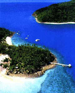
The ferry passed several other islands in the Whitsunday group with some great views. Digby Island, the cattle ranchers dream, is at the south end of the group. Hook Island, in the above picture, is famous for a large population of flying foxes and great snorkeling. The flying foxes hang on high limbs in groups of 50 or more. It was a little surprising that you can walk on trails just below them and they don't move an inch. One day, I was snorkeling by the underwater observatory (white pier looking thing) and startled several people on a day trip. I stayed on the island for 3 days and then decided to start the long, long trip back.
The ferry, bus, and train took 31 hours to get back to Brisbane. The train ride was better than I expected because I got a little sleep and was able to walk around. I stayed another 24 hours in Brisbane to catch up on my sleep, change my plane reservations, and do a little more sightseeing. The trip back to Austin was another 25 hours and I arrived one tired traveler!
Australia is really a great place!