| Fill in the blue boxes ! |
|
|
|
| Yellow box means directions |
are provided at the end. |
|
|
| |
|
|
|
| Distance: |
18 miles |
|
|
| Name of Run: |
The Train Run ! |
|
|
| Start Time: |
6:30 - train leaves 6:45 sharp! Cost $2.50 (1 way) |
|
|
| Start Place: |
Norristown Transportaion Center |
|
|
| |
The train arrives in Manayunk approx. 7:05. |
|
|
| |
Walk to the trail and start running by 7:15. |
|
|
| Volunteers email: |
Name/phone |
Water Stop |
Location |
| @ |
( ) - |
mile 3 |
Shawmont on bike path |
| @ |
( ) - |
mile 6/7 |
Conshohocken Train Station |
| |
Everyone bring's a bottle for this stop |
mile 10 |
Norristown Transportation Center |
| |
Water fountain on bike path |
mile 12 |
bike path |
| |
Fast Tracks in Betzwood |
mile 14 |
Fast Tracks around 9:40 |
| |
Water fountain on bike path |
mile 16 |
bike path |
| |
Everyone bring's a bottle for the end |
mile 18 |
Norristown Transportation Center |
| Planner's Name: |
|
|
|
| Planner's Phone: |
|
|
|
| Planner's Email: |
|
|
|
| Notes about the run: |
For this run, someone needs to put water at Shawmont and |
|
|
| |
Conshohocken the night before. Each runner must also bring |
|
|
| |
$2.50 to pay for train and refreshments for mile 10 and the |
|
|
| |
finish. A bathroom can be found at the Transportation Center |
|
|
| |
inside the building at the top of the stairs on the left and |
|
|
| |
at the Betzwood parking lot (mile 14). |
|
|
| |
This run can be modified to add or subtract miles by adjusting |
|
|
| |
the miles after reaching the train station at mile 10. |
|
|
| |
|
|
|
| Sample email message: |
Welcome everyone to the famous Train Run – 18 miles. |
|
|
| |
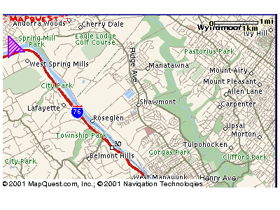
This run starts at the Norristown Transportation Center. We board the train at 6:43 AM and ride to Manayunk. From the station, we walk straight down to the bike path and run towards Betzwood. The cost of the train is $2.50 one way. |
|
|
| |
|
|
|
| |
If you miss the train or would rather not ride the train, just start running towards Center City and meet us on the bike path. |
|
|
| |
|
|
|
| |
It’s 10 miles from Manayunk to the Transportion Center in Norristown. Refreshments will be placed around the town of Shallmont (2-3 miles) and in a parking garage across from the Conshohocken Train station (6-7 miles). |
|
|
| |
|
|
|
| |
YOU must bring you’re own water/gateraide for mile 10 at the Norristown Transportation Center and for the finish. |
|
|
| |
|
|
|
| |
For the remainder of the run, we run an out and back to Betzwood (approx 4 miles). There’s a water fountain on the bike path around mile 12-13 and if we start on time, we should end up at Betzwood for Fast Tracks refreshments (around 9:30) and a little chit chat! But don’t stay too long, you still have |
|
|
| |
4 more miles to run back to the Transportation Center. |
|
|
| |
|
|
|
| |
Directions to the Norristown Transportation Center: |
|
|
| |
From 202 South: |
|
|
| |
Once through King of Prussia, after Henderson Road, bear right onto DeKalb Street. |
|
|
| |
Just after you cross the river bridge, you’ll see the train underpass. |
|
|
| |
If you act quickly, you can make a left before the underpass, into the Transportation Center parking lot. Look for a small blue sign with a ‘P’ for parking. If you made this turn, you’ll be on the correct side of the station for boarding. |
|
|
| |
|
|
|
| |
If you miss the left, just go under the train underpass and turn left at the first red light. The train parking lot is on your left. |
|
|
| |
In order to board the train towards Manayunk, you’ll need to |
|
|
| |
get to the other side of the tracks by walking under the tracks through the tunnel. We will meet on the train platform. |
|
|
| |
|
|
|
| |
Contact: (planner name) at email address xxxx@ or by phone if you can come so we know how much gatorade to bring. |
|
|
| |
|
|
|
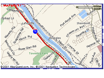
| Directions to Shawmont |
From Norristown: |
|
|
| |
Take Ridge Pike all the way to Shawmont Ave. (this goes through Rockboro). At the end of Shawmont Ave, the road will split and turns to the left up a steep hill. Dont' go left! Go straight! I remember seeing signs that say the road ahead is closed but you can go straight! About 1000 yards past the sign, the road dead ends. This is Nixon Road. |
|
|
| |
Turn right on Nixon road and go about 1/4 mile. |
|
|
| |
The road will turn down towards some train tracks - DO NOT GO there, instead bear right up a little hill - this road is Port Royal Ave (on the map below) but I would hardly call it a road. At the top of the hill, you'll see the bike path and nothing else. Put refreshments here and get the hell out of there! It's spooky at night! Bring a friend!
 |
| |
|
|
|
| |
|
|
|
| To Train Station: |
 |
|
|
| Get on W. Elm Street from Fayette |
|
|
|
| Turn left on Oak Street |
|
|
|