At the first dinner meeting (about 25 folks in the group), Rob Beach, the tour's leader, told us about some of the major differences between driving in the US and driving in Europe. The gist of it was, adapt and improve your riding skills or get squished! These people take their driving very seriously: no screwing around. The typical German is required to take a three-month driving class at a cost of about 1500 to 1800 Deutschmarks (about $800 US) before they are granted a license. Penalties for driving violations are swift and severe. Drunk drivers who have an accident get their license permanently revoked with no second chances. If you flip somebody the finger, that is a $5000 fine and the cop they report it to doesn't even have to have seen it. Drivers in Europe are much more cognizant of motorcycles than are American drivers and will usually yield to us, with the caveat that they will take as much of the road as they need to complete their maneuvers.

Back to Day 1
|
Back to Day 5 |
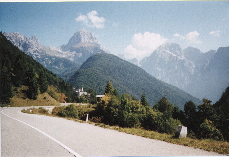
There are about ten significant mountain passes to choose from around Arabba, and since François decided to go hiking above Cortina D'Ampezzo, I started my day's ride with Rob B., heading north, through the Passo di Campolongo (1875 meters) to Corvara. Riders come from all over Europe to experience these twisty heights! Turning west took me through the Passo Gardena (2121 meters). In German, its name is Grodnerjoch. The road to Gardena is high, quiet, and impressive, offering remarkable panoramic views of the Sella Massif. Below the treeline, the forests are thick, lush, and green, but above, the mountain roads are all tight, steep, and fun! Watch out for slippery cowflop, it's open range everywhere! Heading south through the Passo di Sella (Sellajoch) (2237 meters), and then back east through Passo Pordoi (2239 m), with its huge slabs of vertical rock giving it a "Dantesque" quality, took me back into Arabba for a late lunch. Heading east afterward, and circling south then west, I passed thru many small villages and farms, including Pieve, Rocca, Sottoguda, Passo di Fedaia (2057 m) on the Marmolada range, and Canazei.
Back to Day 1
|
Back to Day 5
|
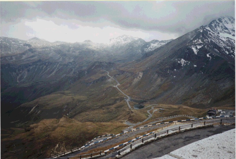
At 2757 meters, the Stelvio is the second highest passroad in the Alps. Originally built by the Austrians in 1824, you can see the Ortles Glacier to the south. At the top is the typical tourist area with a restaurant (many motorcycles parked outside), bar, goodies shop, etc., and we took a break from the cold rain to enjoy a cup of hot chocolate next to a crowd of Swiss skiers who were celebrating somebody's birthday! At the top of the mountain we crossed into Switzerland. We took another goat trail north down the mountain, and as we approached the next village, Sta Maria, one of the first things we saw was an old man riding a bicycle, with a shotgun slung across his shoulder. Gotta love those Swiss! The towns are clean, orderly, colorful and quite pleasing to the eye. Further west, we crossed the Ofenpass (Passo di Fuorn, 2149 m) and went by a portion of the Swiss National Park, 40,000 acres of totally unspoiled land. It is neither "managed" nor manicured by park rangers, vehicles are not allowed through it and it is home to deer, ibex, marmots and chamois. Tired but ecstatic after a great day's ride, we pulled into the pleasant little village of Zuoz, and our hotel for the night, the Hotel Belvair.
Back to Day 1
|
Back to Day 5
|
The morning broke bright and sunny, and François and I headed southwest towards St. Moritz. The road followed a beautiful blue river, dotted with lakes and villages on its banks. Everywhere, the towns are neat and clean, with absolutely no litter anywhere. The Malojapass is relatively low at only 1815 meters, but is nonetheless a perfect biking road. At Castasegna, we crossed back into Italy for a bit and turned north at Chavenna. We were delayed a few minutes by some minor road construction as it twisted up away from the river valley and back into the mountains. Further up, we passed by Montespluga, also called the Surrettahorn in German (3027 m); then riding through the Passo de Spluga (Splugenpass) (2119 m) took us back into Switzerland. The north side of the pass is yet another set of fun twisty hairpins. Turning west at the bottom took us through a deep limestone gorge at Hinterrhein. This section has only been passable since 1822; nowadays the road enters a short tunnel, climbs up a steep hill, goes through a narrow 500 meter gallery, then goes over a 170 meter bridge! The village of Hinterrhein is the last village of the Rheinwald Valley. The Hinterrhein River - the "last part" of the Rhein River - originates west of Chur (pronounced "Cur") at Reichenau and eventually flows into Lake Constance.
Out of the valley and south, the road then took us up the Passo Del San Bernadino. While the valley below was lush and green, at 2065 meters, the pass was barren and rocky. More twisties dropped us back down to Mesocco with its castles and we turned north above Bellinzoma. At Biasca, there was a smaller road to the northeast. Taking that rewarded us with views of der Rheinwaldhorn (3402 m), more twisties and sweepers around Olivone, and a fun fast blast through the Lukmanierpass. Heading west through Disentis Muster, we passed abbeys and churches dating from the eighth century. Many of these abbeys have been repeatedly burned down by assorted invaders and rebuilt over the ages. Today's last passroad was the Oberalppass (2045 m). About fifteen kilometers long, it is usually closed from November through May due to snow. Descending the pass gave us a picture-perfect view of Andermatt, and we pulled in to our hotel for this evening, the Hotel Monopol. At dinner that evening, Mike from Glendale CA wondered if they also have bipoles?... Andermatt is a small town, and we walked end-to-end in about twenty minutes, on cobblestone streets lined with a variety of shops. Its location is the conjunction of four major Alpine roads, and there is a fairly steady flow of people, cars, bicycles, motorcycles and army tanks! In 1382, the town gained independent status and is still a separate district within the canton of Uri.
Back to Day 1
|
Back to Day 5
|
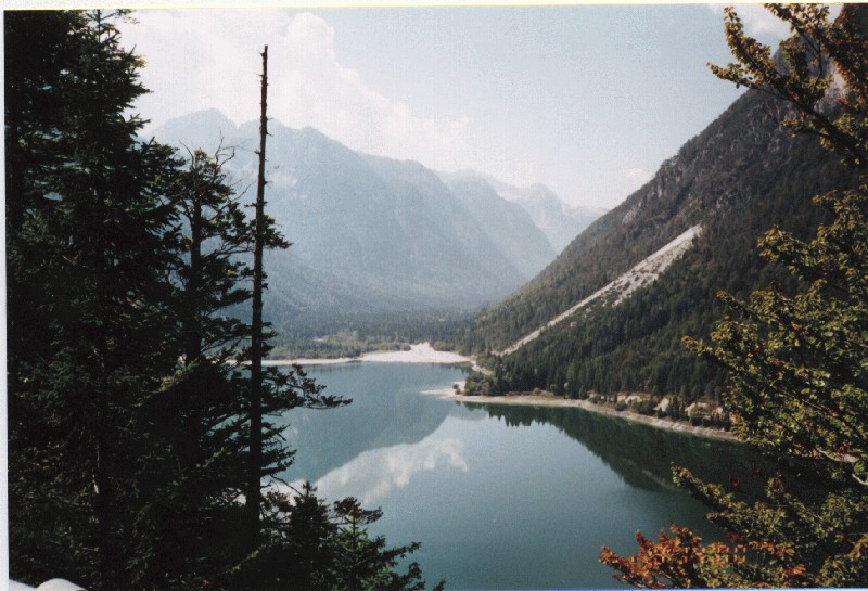
The "lakes district" of Italy, sometimes called the Lombard lakes, includes eleven lakes of glacial origin. The fame of the area arises from the combination of Alpine and southern scenery, usually mild climate, and a phenomenal assortment of lush vegetation. Lago Maggiore is the most famous of these lakes, forty miles long and three miles wide, with a depth of 1220 feet. The northern end of the lake lies in Switzerland and the southern portion in Italy.
At Gogola, instead of taking the more-traveled western route down the lake, we opted to take another tiny little red squiggle on the map (another goat trail through somebody's back yard), and headed south down the eastern side. We got rained on a little, up in the lushly forested green hills, but no big deal. At Indemini, the border crossing into Italy, the guards were very surprised to see us! So few people use this route that they actually wanted to see our passports. Continuing south along the eastern shore of the lake, at Laverno we hopped on to a ferry to cross the lake over to Verbania Pallanza. Our Grand Hotel Majestic was easy to find, on the south end of town.
Back to Day 1
|
Back to Day 5
|
Back to Day 9 |
Undaunted, Francois and I once again opted for the little red squiggle instead of the broad sweep of the autobahn. After exploring around the north side of Verbania for a bit (OK, so we took a few wrong turns and wound up crossing a couple of private estates), we finally headed west and north through Domodosolla. This is a highly industrial town, with row upon row of "factory" housing.
About here, I realized that I had neglected to Scotch-Guard my allegedly waterproof gloves before heading out on this grand adventure. Well, they worked last season... I also decided that stirrups on the rainsuit's pant legs are a good thing, too - my old el cheapo suit at home had them, but this "quality" suit did not, and the legs were riding up my jeans, forcing me to readjust them as we rode. I switched gloves with another "waterproof" pair that I had the foresight to carry; but these got soaked through after a couple of hours as well. Live and learn. Furthermore, water was getting into the upper part of the suit's front zipper, so I was now wet and cold. The heated grips on these bikes do indeed help to alleviate the discomfort!
Bearing to the west, we headed up the Simplonpass (2005 m). Two thousand years ago, Roman legions marched over this footpath on their way north; and up until the seventeenth century, it was used mainly by smugglers, mercenaries, and highwaymen. The Swiss upgraded the road somewhat to accommodate mule trains, but it was Napoleon who developed it into a traversable roadway.
Along with the cold rain, a dense fog had rolled in, so it was fortunate that the pass road is mostly sweepers and swoopies, with very few tight turns. Descending the north side of the pass, at Brig we headed west through the Rhone Valley. Fruits and vegetables grow in abundance in this fertile valley, and Sion is an important market town. Two ancient fortresses overlook this city from high atop twin promontories. Further west, at Martigny we turned south and broke for a hot lunch at a French-style Swiss café. Martigny is criss-crossed with ancient international trade routes, with traffic rolling to France, Switzerland, and Italy; and the city contains the remains of a Roman amphitheater and a forum.
Continuing south, the rain had eased up a bit, but now the fog was becoming even more dense. Wary of other traffic, we climbed up the Col du Grand St. Bernard, the Grand Saint Bernard Pass. This is the highest pass road in the Swiss Alps, at 2473 meters. The conditions were completely whited-out, and we couldn't see more than about fifty feet in most places. At the top, we made the usual stop at the kiosk, and I bought a couple of one-pound bars of genuine Swiss milk chocolate to take home. (Yes, they were yummy!) Also at the top is the famous hospice, founded in 1081 by Saint Bernard of Menthon. This hospice has been manned and maintained by Benedictine monks for over a thousand years, as a place of refuge for the lost and weary traveler. The lake at the top of the pass is typically frozen solid for eight months each year. Yes, there are Saint Bernard dogs here, but they are kept as tourist attractions now, and are not taken out to assist in search and rescue missions.
The records of the hospice tell of the passage of Napoleon and his army in the year 1800. Consider his feat of leading 40,000 French troops over a footpath in the middle of the winter. His engineers widened the path to transport their cannon and supplies for the army. The journey lasted four days, and enabled Napoleon to surprise and conquer the Italians, who thought it was impossible to cross the pass in the winter. The next day, we heard that the pass was closed shortly after we went through it!
Continuing south and down out of the pass dropped us back into northern Italy again. The rain and fog eased up, and at Aosta we turned west, then south, through a conifer forest with the road following a narrow but violent river. At our hotel in Cogne, the Romantik Hotel Miramonte, I hung up my gloves by bungee cords over a heater to dry them out! Unfortunately, due to the wet and foggy conditions, I took absolutely no photos today.
Back to Day 1
|
Back to Day 5
|
Back to Day 9
|
Nearing the little town of Courmayeur, in the southern foothills of the beautiful Mount Blanc massif, it was getting quite chilly. Nearing Mt. Blanc (4807 m), it is easy to understand why it's named the "White Mountain", as it is covered in pristine snow all year long. With the morning sun hitting it, it was blindingly white! I pulled into a diner for a cup of hot chocolate, and met up with four other members of our group, Ken and Lanette from New York, and Graham and Donna from New Zealand. We relaxed for a bit, and continued southwest over the Col San Carlo through La Thuile.
This brought us up onto Le Col du Petite Saint Bernard (also called der Kleine St. Bernard), the "petite" Saint Bernard pass at 2188 meters. The lower stretches of this tight and twisty pass road are frequented by many local motorcyclists, and we were curious why they were going only about half-way up and then turning around. The answer became obvious a little higher up: there was a local storm sitting on the peak! Around one of the upper curves, we hit the wall of wind, sleet and snow. We donned the rest of our warm gear and rainsuits, and picked our way up and across the ice-covered pass road. At the top is a tiny chapel, a statue of St. Bernard, and a few deserted old buildings. It was very slippery, but manageable with due care, and we crossed over into France!
They opted for an easier route after this formidable challenge, but after the twisties coming down the pass into Seez, I headed north at Bourg-St.-Maurice and went up the Cormet de Roselend. This is one of the tiniest little red lines on the map, and much of it is unpaved. The road is very quiet and lonely, with almost zero traffic, but it's peaceful and surrounded by beautiful snow-capped mountains. This took me through the Beaufort region, home of the cows who supply the milk and cream for the Beaufort cheeses.
Over the Cormet de Rosalind (1968 m), I encountered some light sleet, but no big deal. The road went through a forest and alongside several lakes, and at Hauteluce I had to stop for a map check.
These roads are all small and twisty, and there are very few signs for the traveler. I spotted an interesting-looking line on the map called the Col des Saisies, but got turned around and couldn't find it. I accosted a friendly (fortunately!) local farmer, and pulled out my map and compass, and he was able to point me back in the right direction. No wonder I couldn't find it: the Col des Saisies is about six feet wide, looks like an unused driveway between the farms, and is used as an Olympic bicycle training road! In 1992, it was the site of the Olympic cross-country skiing events. I got some "looks" from the cyclists as I rode up the hills to the next town, Flumet.
Turning west onto a real road, I headed up the eastern shore of Lake Annecy. Our hotel for the night, the Hotel Bol Sit (no crude puns here!), is about halfway up the lake in the town of Talloires (pronounced Tal-lo-WA), and sits right on its shoreline. After repairing a broken speedo cable with the spare from our back-up van, I enjoyed a beer and a gorgeous sunset over the lake before dinner. We slovenly Amerikans were the rowdiest group in the hotel's fine restaurant, but they took good care of us, with many different wines during the meal and several cheeses afterward!
Back to Day 1
|
Back to Day 5
|
Back to Day 9
|
Shortly before noon, I turned northeast and headed back up into the mountains, on the beautiful Route des Grandes Alps. This route goes through Thones and St.-John-de-Sixt, with perfect two-lane blacktop road twisting through high farms and forests. Riding over the Col de la Colombiere (1618 m), the road is tighter and more barren, clinging to the mountainside, until it drops back down towards Cluses.
Turning south put me onto the scenic Massif du Mont Blanc road, and as I approached Chamonix, the white mountain once again came into view. The north face is every bit as impressive as was the south, but today was warmer and drier than yesterday! Traffic in this touristy area was heavy but flowing. I passed up on the world's highest cable-car ride, as I could see the cloud on top of the mountain and the winds were swinging the lines! The first stop is at 7,580' and the second, at Aiguille du Midi, is at 12,470'.
After a meal at Le McDonald's - the wall menus were also in English, so I could place an order and impress the gal behind the counter with my excellent command of a foreign language - I turned back southwest to Ugine and north to Talloires. Having time to spare, I did another loop around the lake before dinner.
Back to Day 1
|
Back to Day 5
|
Back to Day 9
|
Spotting a road sign at Cluses that said "Tourist Route", a turn to the southeast rewarded me with less traffic and a narrow road climbing up into densely forested hills. Many of the houses out here were almost entirely covered with planters, sprouting brilliant colors of alpine flowers. At Taninges, a short jog east took me into the spa resort town of Samoens, where I got turned around by the unreadable signs and streets at odd angles to each other. Eventually, I made my escape, and found my way back north, riding past Morzine, with its green pastures and elegant ski chalets.
Continuing north through St. Jean d'Aulps, I followed the river road, turning east a few miles before hitting Lac Leman (Genfer See, or Lake Geneva). More red squiggles on the map led me through Vacheresse, Bonnevaux, and Abondance, all hilly farmlands and forest. At the Pas de Morgins (1369 m), I crossed back into Switzerland. While a beautiful ride, it was a little saddening to note that this pretty much marked the beginning of the return leg of the tour.
The hills down the eastern side of this pass, as far as Monthey, were populated with many bikes and cars hot-rodding around. Shunning the autobahn once more, I turned north onto a four-lane blacktop parallel to it, and rode through the beautiful vineyards and farmland of Aigle. Continuing north to the city of Montreux, our hotel, the luxurious Eden du Lac, was directly on the eastern tip of Lake Geneva. Smack in the middle of the downtown district, it was dense hustle-and-bustle, but orderly (as everything Swiss) and pleasant. There was even a café a few doors down that had a couple of old motorcycles mounted onto its roof as part of its welcome sign!
Back to Day 1
|
Back to Day 5
|
Back to Day 9
|
Back to Day 14 |
While exploring the prison, I went over to the fifth pillar where Bonivard, Prior of St. Victor's, Geneva, was chained for four years. The neck collar used to hold him is a very heavy (yes I lifted it) rusty piece of iron, and I shuddered to think of it chafing and digging into the neck of a prisoner who couldn't even sit down. His crime was championing the independence of Geneva from France, and he was freed by the Swiss on March 29th, 1536.
It was barely noon, so Francois and I set out to the south and headed into Corbeyrier, north of Aigle (Eagle). This is wine country, with immaculate estates, perfect roads, and lush vineyards abounding. Following Rob B's suggestion, we found the tiny one-lane road up into the hills that led into an active Swiss army base. This road is another tight 'n' twisty, with over thirty 180-degree switchbacks, and two short but very dark tunnels, before entering the base. Many other bikes were also enjoying this route, and at the wire gate to the base, they tried to warn us not to go any further. Nonsense, these GS's can go anywhere! Proceeding on in, we saw several signs warning folks to stay on the road (what there was of it), and even a few that were brightly illustrated and saying, "Do Not Pick Up the Bomb!" Continuing up the rough gravel, we passed an active Swiss Air Force rocket range, with a tank on display by the entrance.
Finally exiting upon a real road, we were having so much fun that we agreed to add even more to this beautiful day's ride, and decided to add a roundabout "figure eight" to our route. Turning south for just a bit, we rode through the Col de Mosses, then went east and north through the Col de Pillon. Just above Gstaad we turned back to the west again, along the Pays d' Enhauf road through Chateau-d' Oex, then turned north through Montbovon, Grandvillard, and the walled town of Gruyere (yes, origin of the cheese! pop ~1300). Just before Bulle we turned east and followed the Jaun river road over the Jaunpass (1509 m). Continuing northeast through Reidenbach and Weissenburg, we picked up the autobahn at Spiez, where a twelfth-century castle with a massive tower overlooks the bay, and blasted east, along the Thunersee, over to Interlaken. This name literally means "between the lakes", and the Thunersee and the Brienzersee are known for their abundance of delicious fish. Our hotel, the Hotel Bluemlisalp, is actually in Beatenberg, to the north of and "above" Interlaken. "Above" is putting it mildly: the one road goes up and up, then up some more, and up, and up.... In this luxurious ski resort, we two guys were put into an apartment obviously intended for a family of six or eight skiers - wow! From our balcony we could look straight across the lake and see several mountains in the 4000-meter range, including the Jungfrau (Young Miss), the Monch (Monk), and the Eiger!
We agreed that the next item on the list was to go see Trummelbach Falls, above the Lauterbrunnen Valley. This waterway isn't "just" a waterfall - it's the outlet of a glacier, inside the Jungfrau mountain! Accessed by a 100 meter elevator ride, and then a walk through a small, dark, damp tunnel, its five cascades have cut a narrow gorge through the mountain over the millennia. The roar of the icy water is deafening as it plunges madly down the gorge and corkscrews out the side of the Jungfrau.
Francois and I took a break for mittagessen (mid-day eats), and John rode out on his own. After lunch, Francois rode back to the hotel for a much-needed nap, and I went exploring around Grindelwald, "Glacier Village". Southeast of Interlaken, this little town is surrounded by high mountains, alpine pastures, and woods, forming a beautiful setting. Taking the high road to the end of town afforded me a wonderful view of the chair lift up the Kleine Scheidegg (2061 m). It was beginning to drizzle, so I passed on the cable-car ride up the Schilthorn, with its views of the Eiger and the Jungfrau, and the revolving Piz Gloria restaurant (of James Bond fame).
The wet cloud was beginning to let go in the valley here, so I headed out east along the Brienzersee (Brienzer Sea) back into the sunshine. This lake is, by tests, the cleanest of all of Switzerland's larger lakes, and fish restaurants are plentiful. On the northeastern end of the lake is Brienz, the center of Swiss woodcarving art. There are several schools here, and shops displaying their wares along the sidewalk. Riding west along the north shore took me back into Interlaken, where I wandered the streets a while, looking at all the tourist shops; then it was back up (and up, and up...) into Beatenberg for dinner.
Following the Aare River south took us to Meiringen and past the Reichenbach Falls, where Sherlock Holmes allegedly met his death at the hands of the evil Professor Moriarity. Here we turned east, and past the town of Badmen (really!), we climbed the fun twisty sweepers of the Sustenpass. The pass road tops out at 2224 meters, but affords spectacular views of the snow-capped Sustenhorn (3504 m). As usual, there were many other bikers out enjoying the ride, the cool air and the sunshine. Down the other side through Farnigen, we turned north at Wassen and continued up to Altdorf. Here there is a little Kaffe und Kuchen restaurant set up by the famous statue of William Tell, but the size of the crowd convinced us not to stop.
Heading east on the easy swoopies following the Schachent River, we spotted a very tempting-looking road back up into the mountains, but it had a sign: a red circle filled with white. This means "All Vehicles Prohibited", but we took it anyway! This took us straight up onto the Klausen Pass (1950 m). Originally built in 1893, it has an 8.5% gradient, and used to be a site for car and motorcycle races. Besides the typical kiosk at the top, there is also a small weather station; and the Swiss army had a base set up (today, at least) in the valley just before Spittelruti. Continuing along the river road, we stopped for a hearty beef-and-noodles lunch, and watched many more bikes going up and down the pass, including several from our own group!
Sated and rested, we continued north along the Linth River until it dumped into the Walensee at Nafels. Back in 1388, Nafels was where the Swiss battled successfully against the Austrian Hapsburgs, who had a superior force made up of the elite of Austrian nobility. Further north, we got into the Toggenburg range of mountains. The Toggenburg area was once an independent country, but is now part of the canton of St. Gallen, and has a variety of industries. The economic hub of the area is Wattwil (I don't know, what won't?), a longish straggling town of about 9000, and here we turned east to follow the Thur River into Unterwasser. Sheltered between the Santis chain and the Churfirsten range, Unterwasser is lush, hilly farmland. After checking in at our Hotel Santis, I rode over to the local Moto Guzzi & Aprilla shop, to check out some local iron and pick up a tee-shirt. I was disappointed to learn that "shop" shirts are mostly an American custom, and all they had were shirts with the brand name but no shop name. The hotel was also base for a company of Swiss soldiers, and they freely walked around carrying their Heckler & Koch and SIG arms. At dinner, we had a pleasant change: a big shark steak! And Kimi-san, a geological engineer from Nevada, bought a bottle of the local "Monica" wine, which he shared with everybody.
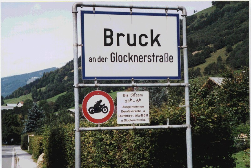
Turning north, we headed through the low mountains and forests around Egg, crossed over into the southwestern tip of Germany at Balderschwang, and headed for Burgberg. This is the home of the Held Leather factory outlet store, and they have literally Everything that can possibly be made of leather. Many of our group took advantage of the low prices - and the idea that if you're wearing it, you can probably get away with not paying duty on it at Customs - and purchased gloves, jackets, pants, and complete riding suits. Afterwards, turning towards the east brought us over the Oberjoch and back into Austria. While not very high (1178 m), the "over pass" was very twisty and fun, with a few deceptive off-camber curves just to keep you honest. Turning south into the Lechtaler Alpen, we encountered a light, cool rain as we climbed the Hantennjoch (1894 m). This rocky pass was almost devoid of other traffic, and the dark clouds made it feel tighter than it really was. Down the southern side, we broke out of the clouds and found our way to the Hotel Linserhof in Imst, our dinner and refuge for the night.
As neither Francois nor I were much interested in historic castles, we headed straight north up towards the Fernpass. It was very damp and foggy this morning, with dense clouds settled into the lower valleys and visibility poor, so we were cautious climbing the unfamiliar mountain road. Wending our wanton way through the countryside, we broke through above the clouds as we crossed the Fernpass (1216 m) and beheld why Emperor Maximillan the First chose this land for his hunting lodge. The profusion of green forests and blue lakes served only to reinforce our feelings that not only are the Alps loaded with so many great places to ride, but the diversity of beauty just makes it that much more difficult to ride away from them.
On another little-traveled "red line" back road, we barely noticed the tiny sign marking the border as we crossed out of Austria and into Germany below Schwangau. The land quickly flattened out into (comparatively) boring farms, and traffic increased as we passed through Steingaden, Peissenberg, and Weilheim. We stopped for a great lunch at a Chinese restaurant with Francois protesting: "I fly many thousands of kilometers from Quebec City to ride thousands of kilometers in Europe's Alps, and you want me to eat Chinese food?!" But I was pretty fed up with pork and beef in heavy salted gravy, with potatoes and noodles, and I was ready for something low-fat, low-calorie, and nutritious. I picked the place well; after a few bites, Francois was also thoroughly enjoying his meal. We hit the road for the last leg back up into Olching. Parked once again in the lot of the Landhotel Am Muhlbach, we sort of looked at each other for a moment: "Darn...we're back..." A quick shower, and we headed down to the dining room for the briefing on tonight's activities. We were going to the real, genuine, one and only OKTOBERFEST!!! A quick walk over to the train station with the rest of our group, repeating the confusion of trying to buy tickets again, and we rode back into downtown Munich to PARTY!
The Oktoberfest is held annually for sixteen days at the Theresienwiesse, Theresa's Meadow. The celebration is a remembrance of the festivities held in honor of the engagement of Crown Prince Ludwig and Princess Theresa in 1810. Because of typically inclement weather in October, it was rescheduled many years ago for September and just a few days in early October. These days it is a huge affair. Besides the consumption of about four Million liters of beer, there is also food (three thousand pounds of beef, chicken, and fish daily!), amusement park rides, games, candy, vendors, and people everywhere. This year, eleven "tents" (actually temporary beer halls), each sponsored by a local Munich brewery, were set up, and each tent was rated for a capacity of five thousand people. By six o'clock, there was not even room to walk! Fortunately, we had reserved tables for our group, quite properly in the Hofbrau Munchen with its Bavarian flags, and were served up with liters of ein wirklich Konigliches Bier - the king's finest beer! Then came a roast chicken dinner with trimmin's, and of course the obligatory oom-pah band playing the whole time. The waitresses were buxom, everybody was singing along and dancing (it didn't matter if you knew the words or not), and we all had about six or seven thousand new friends. My first liter went down easily and perhaps a little too quickly, 'coz I was feelin' good! I nursed the second liter a bit longer; this was not "American" beer, it's more like ten or twelve percent stuff! After a while, I decided to go walking around and exploring the grounds, so I excused myself and went outside. Perhaps stumbling and drifting around better describes it, but at least I knew better than to try any of the wild amusement park rides in my inebriated condition. Not far away was the Paulaner beer hall, so of course I just had to go and get another liter. Eating, drinking, snacking, singing, picking up a few souvenirs, and by eleven o'clock or so, I was ready to call it a night. The other tourists guided my cloudy self back to the train station in a variety of languages and gestures, and I actually managed to get back to the hotel before finally passing out.
Taking a stroll around Olching, I decided to visit the local BMW shop, Sherb Motors. Once again I was disappointed that "shop" t-shirts are an American custom, and I explained to them that they could probably sell every one they made to the American motorrader! I did, however, buy several spritzers of BMW's visor cleaner, which is no longer available in the U.S., thanks to our nanny safetycrats.
Walking around not only helped to clear my head, but gave me the opportunity to observe close-up the everyday lifestyle of the local businesses and townspeople. It really wasn't very much different from any bustling suburb here, except that it was quieter and much cleaner. I window-shopped, browsed, and sometimes stopped in at one of the many cafés for munchies.
Back at the hotel that afternoon, it was again party time - this was very our last dinner together, several of our motley band of biker bums having already been taken to the airport for their flights home. Many beers were hoisted in salute to our new friends, and hugs and kisses were shared all around. We had all secretly chipped in to give Graham and Donna a bottle of champagne, as this was their twentieth anniversary; and we had also tied many twenty-dollar bills to the bottle with ribbons, in thanks for their hauling all of our luggage around, not only in the van every day, but also carrying it upstairs in each new hotel every night! With appropriate savior-faire, Rob gave a little "thank you and congratulations" speech and handed out our Certificates of Accomplishment for bravely daring the elements and hazards of the Alps.
Flying out the next morning brought me back to reality, the vacation was truly ending. While a trans-Atlantic flight is typically boring, it was interesting to see icebergs in the north Atlantic, and the snow-covered mountains of Greenland. I didn't bother to declare the several big Swiss chocolate bars, nor the two huge Oktoberfest beer steins, at the Atlanta Customs check; and at LAX, I was actually quite pleased with the exchange rate of Swiss francs to American dollars!
I hope you have enjoyed reading this log of my adventures on Beach's Oktoberfest Olio; it was the adventure of a lifetime and I'd do it again in a second (taking different "red squiggles", of course)! Travel by motorcycle is the best kind of vacation one could possibly take, especially when every curve and corner brings something totally new. When deciding on a road, take the one less traveled; if you can already see around the bend, choose another path. Ride well.